SAM IS ....
ARPAS-UK welcomes PwC UK as a new member

ARPAS-UK is delighted to welcome PwC on board as a member. A report published last year by the PwC UK drones team predicted that drones could contribute as much as £42bn to the UK economy by 2030 and employ around 628,000 people working in related businesses.

With significant opportunities for economic gains across all sectors, ARPAS-UK continues to advocate on behalf of the whole drone industry, with government, regulators, universities and private industry.

Graham Brown, CEO of ARPAS-UK, said: “The ARPAS committee has been working tirelessly this year to increase the influence and relationships with regulators, government departments such as DfT and BEIS, All Party Parliamentary Groups, industry trade associations and consultants. PwC has one of the leading drone consulting capabilities in the market and having them on board demonstrates the progress that ARPAS has made this year.”

Elaine Whyte: “Our drones team at PwC UK has now been up and running for a year, helping clients take advantage of this emerging technology and extract value from drone data. In our Skies without Limits report we recognise that there is substantial opportunity in the drones market but this can only be achieved if we maintain and build trust. Having a professional body to represent the industry is an important layer of this trust and we are looking forward to working with ARPAS to support their mission to promote the safe use of drones.”

SAM IS ....
International Drone Competition Returns to North Wales

An international drone competition returns to north Wales June 16-18 with Welsh Government backing and a home team competing from Wrexham Glyndwr University.

The UAS (Unmanned Aircraft Systems) Challenge is an international student drone design competition organised by the Institution of Mechanical Engineers. This year the event is attracting a record 32 teams comprising hundreds of young engineers from as far afield as Pakistan, Sri Lanka and Canada, along with first timers from Denmark and the Netherlands.

The Challenge is staged over three days in the spectacular Snowdonia Aerospace Centre at Llanbedr, part of the Snowdonia Enterprise Zone, and has been building popularity over the past five years.

Colin Brown, Chief Executive of the Institution of Mechanical Engineers, said:

“We are delighted the Welsh Government has taken this opportunity to support the competition. The Challenge brings leading-edge drone technology to north Wales, which will raise the area’s aerospace profile internationally and help develop the regional skills base.”

The event benefits from the excellent facilities and infrastructure at the Snowdonia Aerospace Centre, itself a well-known drone-testing site which creates a supportive environment for developing this cutting-edge technology, and which has the opportunity to form alliances with academic and industry partners taking part.

The Challenge gives undergraduates an insight into the role of aerospace engineering on real-world projects, such as simulating a humanitarian aid drop, and requires a great deal of innovation from the students.

Read more

By Beth Perry

27/2/2019


SAM IS ....
New drone safety partnership with business launched as Government sets out plans to limit drone misuse
ARPAS-UK, the UK Drone Association fully support the initiatives announced this morning and believe they are important to help ensure safe and secure flying.
We are also pleased about the focus on education and believe it compliments the activities of the Drone training organisations (NQEs) and our members who spend time providing education to schools and the public. It is to be noted that it also compliments the activities of Devon, Cornwall and Dorset Police and their Safer Drones workshops.
We look forward to continuing our work with DfT, the CAA and the U.K. drone community, on the initiatives announced as well as new counter drone technology that we believe will help deal with those intent on operating illegally.

Official Announcment follows:

  • Extended ‘no-fly zone’ banning drones and model aircraft from 5km of runways to come into force next month
  • Government to give police new anti-drone misuse stop and search powers
  • New partnership with retailer as part of a national campaign ahead of new law

The government and the Civil Aviation Authority (CAA) have today (20 February) announced a new partnership with the retailer Jessops, as part of a national campaign to increase public awareness of the rules around flying drones. Working with the CAA, the government is dialling up a campaign to help educate the public about responsible drone use, including issuing a digital toolkit to airports to help them raise awareness of the new rules.

Following on from new laws last year restricting the use of drones and bringing forward a new drone-users register, today, the government also announced new legislation to extend the ‘no-fly’ zone around airports, banning drones from flying within 5km of runways.

The new exclusion zone will be increased by several kilometres, including banning drone flight within 5km of runway ends. The enlarged zone will better protect the UK’s airports from those misusing drones, and will come into force on March 13.

Work to progress a new Drones Bill is also underway and will be introduced in due course. It will give police officers powers to stop and search people suspected of using drones maliciously above 400ft or within 5km of an airport – helping them to tackle disruption such as that seen at Gatwick in December. It will also give additional new powers to the police to clamp down on those misusing drones and other small unmanned aircraft – including the power to access electronic data stored on a drone with a warrant.

Transport Secretary Chris Grayling said:
“The law is clear that flying a drone near an airport is a serious criminal act. We’re now going even further and extending the no-fly zone to help keep our airports secure and our skies safe.
“We are also working to raise awareness of the rules in place. Anyone flying their drone within the vicinity of an airport should know they are not only acting irresponsibly, but criminally, and could face imprisonment.”

Home Secretary Sajid Javid said:
“Extending stop and search to include drones will help police tackle disruption like the recent misery we saw at UK airports, when travel was ruined for thousands of innocent passengers, and bring those responsible to justice.“Police are clear that stop and search is one of the most powerful tools they have to target and disrupt crime and I remain committed to giving them all the support they need to protect the public.”

Ian Savage, Head of Retail and Academy Training at Jessops, said:
“Drones are one of the most exciting ways of capturing stunning aerial photos and videos, and with prices more affordable than ever they are within reach of any budding photographer and videographer. Many are intuitive and simple to operate, making them ideal for beginners, while the more sophisticated models now offer features such as full manual control of the camera and stunning 4K 60fps video, that help advanced photographers take their shots to the next level.

“Along with the pleasure drones bring comes a responsibility for the user to ensure they are flying their drone safely and legally. As one of the leading drone retailers Jessops is committed to ensuring it communicates the new laws to all its customers, and it will be doing this through extensive training from our dedicated drone specialists Connor Keenan and Jon Dick.”

Tim Johnson, Policy Director at the CAA, said:
“It is illegal to fly drones close to airports and anyone flouting the rules can face severe penalties including imprisonment. Anyone operating a drone must do so responsibly and observe all relevant rules and regulations. The rules for flying drones are designed to keep all airspace users safe.

“The CAA’s Dronecode provides advice on how to fly your drone safely and follow the rules. you can see it at www.dronesafe.uk “

The Home Office is also reviewing the UK’s approach to countering the malicious use of drones, and will consider how best to protect the full range of the UK’s critical national infrastructure – including testing and evaluating technology to counter drones.

The Home Office will also extend stop and search to people suspected of carrying corrosives substances in a public place, which will help prevent acid attacks. Currently, they must be suspected of intent to cause injury.

~ Ends ~

NOTES

  • It is already against the law to fly a drone above 400ft or within 1km of an airport boundary. If you recklessly or negligently endanger an aircraft with a drone it is a criminal offence and you could go to prison for up to five years.
  • The intentional use of a device to commit an act of violence at an airport which could cause death, serious personal injury or endanger safe operations could result in life in prison, under the Aviation and Maritime Security Act.
  • It is against the law to fly a drone near an airport or airfield boundary. Report suspicious drone activity to your local police or call Crimestoppers UK on 0800 555 111.
  • The extension of stop and search to misuse of drones will include their associated items including sim cards and controllers.
  • The Government is also working closely with the police to examine whether they have the appropriate powers to respond effectively to other offences that might be committed using a drone. If this work reveals further operational gaps, the Government will take further legislative action.
  • From 30 November 2019, operators of drones between 250g and 20kg will be required to register and drone pilots take an online competency test. This will improve accountability of drone use and ensure the UK’s skies are safer from irresponsible flyers.
  • Drones with an operating mass of more than 20 kg are subject to the whole of the UK Aviation regulations (as listed within the UK Air Navigation Order – ANO).
  • The CAA’s ‘dronecode’ provides advice on how to fly your drone safely and follow the rules at all times. More information on the rules for drone users can be found atwww.dronesafe.uk
  • The new exclusion zones will be increased to the current Air Traffic Zone (ATZ) around airports (approximately a 5km radius circle), with additional extensions from runway ends.
  • The CAA holds partnerships with retailers who follow a specific set of guidelines when selling drones, to ensure consumers properly education on when, where, and how they can use their drones safely. Consumers are encouraged to look out for the DroneSafe symbol to ensure they are buying their drones from a trustworthy and responsible supplier. Find out more here.
  • The partnership with Jessops follows the retailer’s commitment to clearly advertise drone rules to their customers.
  • Drone users can fly within the restriction zones if they have the correct permission from air traffic control or the airport.
SAM IS ....
ARPAS-UK to partner The Commercial UAV Show 2019

Celebrating its 6th year in 2019, this free to attend show prides itself to be a one-stop event that brings together the technology and the experts that will keep you ahead of the exciting changes developing throughout the UAV ecosystem.

This year’s exhibition will display the latest in aircraft manufacturing, regulations, systems, components, service companies, etc., providing an all-round knowledge on this multi-industry revolutionising technology.

Our high-level conference will cover key topics such as: innovative aircraft design and control systems, new regulations, urban innovation and autonomy, data management and integration, mapping and surveying techniques, enterprise solutions, and so much more.

Where else in Europe do you have free access to hundreds of global leading and innovative companies all on one giant floor?

The Commercial UAV Show will showcase:

  • An exhibition floor full of the market’s most exciting UAV manufacturers and users
  • A vibrant and interactive platform to meet new suppliers, benchmark pricing and purchase new products
  • A brand-new agenda relevant for both smaller enterprises and large-scale businesses composed of 3 different programmes:

–          Our main conference

–          A brand-new VIP UTM Summit which will welcome senior representatives all-across the sector in one place, allowing them to meet, network and discuss current and futures industry challenges and solutions

–          Our seminar theaters which include our brand-new Careers’ Zone aiming to offer participants all the tools they need to kick-start their careers in the UAV industry

And so much more!

So, if you are looking to get ahead in the commercial UAV industry then The Commercial UAV Show is the place to be this November 2019.

SAM IS ....
FAA Announces Change To Drone Requirements

The Federal Aviation Administration (FAA) has posted a rule in the Federal Register requiring small drone owners to display the FAA-issued registration number on an outside surface of the aircraft. Owners and operators may no longer place or write registration numbers in an interior compartment. The rule is effective on February 23. The markings must be in place for any flight after that date.

When the FAA first required registration of small drones in 2015, the agency mandated that the registration marking be readily accessible and maintained in readable condition. The rule granted some flexibility by permitting the marking to be placed in an enclosed compartment, such as a battery case, if it could be accessed without the use of tools.

Subsequently, law enforcement officials and the FAA’s interagency security partners have expressed concerns about the risk a concealed explosive device might pose to first responders upon opening a compartment to find a drone’s registration number. The FAA believes this action will enhance safety and security by allowing a person to view the unique identifier directly without handling the drone.

This interim final rule does not change the original acceptable methods of external marking, nor does it specify a particular external surface on which the registration number must be placed. The requirement is that it can be seen upon visual inspection of the aircraft’s exterior.

The FAA has issued this requirement as an Interim Final Rule—a rule that takes effect while also inviting public comment. The FAA issues interim final rules when delaying implementation of the rule would be impractical, unnecessary, or contrary to the public interest. In this case, the agency has determined the importance of mitigating the risk to first responders outweighs the minimal inconvenience this change may impose on small drone owners, and justifies implementation without a prior public comment period.

The FAA will consider comments from the public on this Interim Final Rule, and will then review any submissions to determine if the provisions of the ultimate Final Rule should be changed. The 30-day comment period will end on March 15, 2019. To submit comments, go to http://www.regulations.gov and search for “RIN 2120-AL32.”

As Transportation Secretary Elaine Chao promised last month, today the FAA also posted proposed new rules to let drones fly routinely at night and over people, and to further integrate them safely into the nation’s airspace. The comment period for these proposals begins tomorrow and will end April 15.

Learn more at faa.gov

SAM IS ....
What are the Highest Causes of Coverdrone Claims?

Drone claims can come in all shapes and sizes and can occur due to a variety of different reasons. Although we are always on hand to handle your claim in the most efficient and effective way possible, we understand that you would like to reduce the likelihood of an incident happening to a minimum. Below we have listed our top five causes of claims and have provided some advice on how these sources can be avoided and therefore reduce the risk of having to make a claim!

  1. Pilot Error

Our highest cause of accidents and incidents are due to pilot error and it is important that you, as a drone pilot, are aware of the elements that can cause failure to perform to a satisfactory standard. There are many mechanisms of human performance that can change a flight drastically and being made aware of these influences may help you conduct the safest flight possible.  Below is a list of human factors that can affect your flight:

Lack of Communication: Poor communication is one of the main contributing factors in accident reports due to the information being exchanged being unclear or inaccessible and the person receiving the information may make assumptions about the meaning of this information. We recommend that any detailed information that needs to be passed between yourself and your team that is complex, should be written down. For example, log books, checklists and worksheets are useful resources to use. Verbal messages can therefore be kept short. As the remote pilot, always give your team the chance to ask questions before a flight so that no assumptions are made.

Lack of Knowledge: Aircraft systems are complex pieces of equipment and it is therefore vital that pilots have gone through the substantial and necessary training in order to operate safely. Furthermore, lack of on-the-job experience may lead to pilots misjudging situations and making risky decisions. As drone systems continue to develop, pilot’s knowledge and experience with the product may quickly become out of date. It is important that you, as a pilot, undertake continuous professional development and that you share your knowledge with other colleagues within the industry. Checklists and CAA publications are good methods to follow and refer to so that assumptions are not made and that you are not relying on memory.

Lack of Resources: Regardless of the task, resources also include personnel, time, data, tools, skill, experience. A lack of any one of these resources will affect a person’s ability to complete a task. When the proper resources are available, and to hand, there is a greater chance that we complete a task more effectively, correctly and efficiently.

Pressure: If you are operating commercially, you may experience pressure from your client in order to complete a job within a specific time frame. This can interfere with the quality of your performance which is therefore endangering the safety of your flight. Always ensure that any work you commit too, can be dealt with in an unpressurised environment.

Other elements that you may wish to consider are complacency, distraction, lack of teamwork, fatigue, stress, lack of assertiveness and lack of awareness.

  1. Accidental Damage

“Accidental Damage” is defined as damage that occurs suddenly as a result of an unexpected and non-deliberate external action. In simple terms, this usually means an unintentional one-off incident that harms your property or its contents. This is our second biggest cause of claims.

The Civil Aviation Authority have put strict regulations in place and drone pilots have to meet the criteria that has been set out in order to fly legally. However, situations can occur which are beyond your control. In order to reduce the risk of accidental damage, there are a number of factors that you may wish to consider which are stated below:

  • Do not fly your drone in turbulent weather: As a drone operator, it is important to understand that weather is an important factor in any form of aviation. Any operation effectively planned with the weather in mind, not only increases the safety of your operations but also helps to improve the quality of any materials gathered.
  • Always store your drone and equipment in premises which are weather proof: Not all drones are waterproof so it is therefore important to ensure that your equipment does not get wet which could result in serious damage.
  • Whilst transporting your equipment too and from location ensure that you use a good solid carry case: This will therefore reduce the risk of the equipment being damaged whilst being transported, if it were to be dropped for example.
  • Never be negligent with your equipment.

We have found that accidental damage does not tend to occur often whilst in flight and is more apparent when transporting equipment. We have therefore included this feature within our policies in which full policy cover is in force whether you are flying your drone, transporting it to and from location, or safely storing it (subject to certain excluded territories).

  1. Mechanical Failure

Our third highest cause of claims is mechanical failure. In order to avoid the risk of mechanical failure, we suggest that although there are no airworthiness requirements within the majority of countries, it is your responsibility to maintain your equipment to the highest standard. If you are trying to operate an old or damaged drone, then you may be putting yourself under unnecessary pressure. This is inclusive of regularly updating the software.

Further to this, always ensure that you are flying within manufacturing guidelines. All drone manufacturers will have a set of guidelines that pilots should adhere to in order to guarantee a safe operation. We suggest that you always refer to your pre-flight checklist prior to your flight in order to ensure that you have gone through all mechanical and safety checks that are required.

  1. Loss of Data Connection

Loss of data connection is our fourth most common cause of claims. Loss of data connection can occur due to electromagnetic interference which can happen when flying near power lines and telephone towers. In order to negate the likelihood of damaging your equipment in this situation there are two factors that you may wish to consider:

  • Ensure safety functions are pre-set before flight: The Return to Home (RTH) is useful function that can be used manually by the pilot to land the aircraft at the touch of a button or automatically if the signal is lost between the drone and controller. The automatic functions are useful safety measures to give an added level of peace of mind when flying your aircraft. At the beginning of each individual flight, set a new Home Point and make sure that you have at least four (five recommended for flying) GPS bars and double check the Home Point has been set before setting off.
  • Ensure everything is working correctly at a low altitude: Begin by taking off and maintaining a low altitude of around 10 feet. From here, ensure that the aircraft can properly ascend and descend, move in all directions and rotate from side to side.
  1. Flyaways

In joint fifth place, we have found that flyaways and theft of property are a common cause of claims.

Firstly, we shall discuss flyaways. The FAA defines a flyaway as “an interruption or loss of the control link, or when the pilot is unable to effect control of the aircraft, and as a result, the UAV is not operating in a predictable or planned manner”. In simpler terms, flyaway are situations when a drone starts exhibiting erratic movement. Below is a list of factors that can cause a flyaway:

  • The return to home function has not been configured correctly: Most drones today will set the home point automatically for the return to home function. However, you should ensure that the particular model that you own has this feature and if not, make sure that you have set it up correctly. If you are going to be on the move whilst flying your drone (if you were on a boat, for example), make sure that you have the dynamic home point set up.
  • Compass interference: GPS signal is necessary but not sufficient for your drone to return to home safely. Your drone’s compass also needs to be relatively free from interference. GPS only determines the drone’s location; the compass determines its orientation. If you initiate ‘Return to Home’ your aircraft will turn its head and fly back to the Home Point. But if it doesn’t know which way to turn, it may end up flying somewhere else. If you are travelling regularly, your drone compass is going to get unaligned with the electromagnetic field of different areas. Always ensure that your compass is calibrated correctly.
  • Flying beyond visual line of sight: Within nearly all countries, flying beyond visual line of sight requires special permissions, however losing sight or orientation of the drone is one of the most common reasons for a drone fly away and/or losing a drone. Your drone is much less likely to crash or get lost if you can see it. Monitoring your drone solely through your live video feed is never a good idea. If you do this, you may not be able to see what is behind or to either side of your drone. Sometimes, flyaways are just accidents simply resulting from the drone not being visible.


  1. Theft of Property

Theft of property is an unfortunate incident that cannot be helped. In order to prevent easy access to your equipment always ensure that it is stored in the safest possible environment – ideally in a locked area, building or vehicle and out of visual site. Furthermore, do not leave any items unattended in a public area.

Our Annual Policy Provides Piece of Mind

Our industry leading annual policy is the most cost-effective policy for a frequent drone user, however, it also gives you piece of mind that your equipment is covered all year round. If accidental damage or theft of property were to occur and you had opted for a short-term policy, this type of cover would only be in place during the dates you had selected to cover. It is therefore worth considering an annual policy to have this type of security in place all year round.

If you have any questions with regards to what has been discussed within this article or would like to obtain a quote for either of our annual or short-term policies, please contact a member of our team.

www.coverdrone.com

SAM IS ....
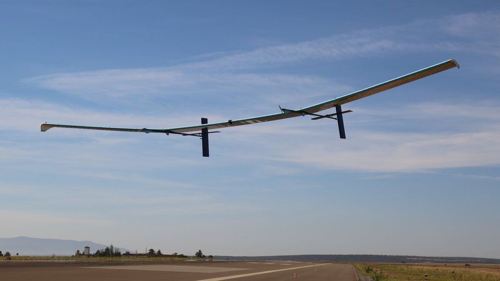
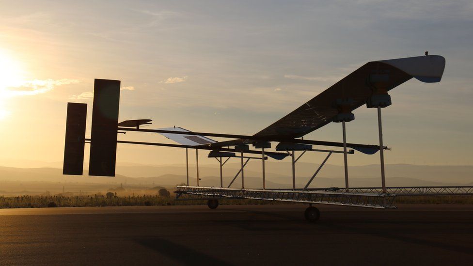
Ordnance Survey to launch mapping drone
Image copyrightORDNANCE SURVEYAstigan drone

Mapping organisation Ordnance Survey plans to launch a solar-powered drone to capture higher quality images of the Earth.

Its Astigan craft will fly higher than commercial airliners at 67,000 ft (20,400m), and could circle the Earth for 90 days before it needs to land.

It will collect images and data for businesses and organisations to use.

It hopes to launch “fully operational high-altitude tests” of the craft before the end of 2019.

Ordnance Survey owns 51% of Astigan, which is based in Bridgwater, Somerset.

It operates from the same factory that once housed Facebook’s Aquila internet drone project.

Image copyrightORDNANCE SURVEYAstigan drone

The space became available after Facebook abandoned its drone plans, and the company says there is otherwise no link between the two drone projects.

Ordnance Survey told the BBC that the existing mapping satellites orbiting the Earth cannot provide enough high resolution detail for its maps.

Its Astigan drone is a high-altitude pseudo satellite. Rather than circling the planet, it will be controlled from the ground and sent to map large areas of interest.

“Our current mapping capabilities are driven by two efforts,” explained Neil Ackroyd, acting chief executive of Ordnance Survey.

“One is using fixed-wing aircraft to take photos for our revision programme. Then we have our field surveyors on the ground, supported by data from local authorities and the land registry.

“What the Astigan project does is gives us the capability of using aircraft, but quicker and at significantly lower cost.”

The cameras the Astigan craft will carry will be similar to those on mapping aircraft. Ordnance Survey said it would not be possible to identify people on the images.

“It’s hard to see people vertically, as you can only see the top of people’s heads,” said Mr Ackroyd.

The drone will be used to collect images and data for use in commercial and industrial applications, so the images are unlikely to show up on services such as Google Maps or Bing.

As well as mapping the UK, Ordnance Survey plans to offer mapping services to countries that otherwise struggle to afford them because of the cost or their large geography.

The platform will also be made available to companies who want to attach their own sensors and cameras, for example to track climate change.

From BBC  by Chris Fox, Technology Reporter

13/2/2019


SAM IS ....
Commercial UAV Expo Europe 2019: 8-10 April 2019

Commercial UAV Expo Europe is the leading trade fair and conference focusing on the integration and operation of commercial UAS throughout Europe and internationally.

Industries covered include Process, Power & Utilities; Civil Infrastructure; Construction; Aggregates & Mining; Surveying & Mapping; Public Safety and Security; and Precision Agriculture.

The conference programme addresses such topics as the regulatory landscape, safe integration of UAS into the airspace, ATM, U-Space and disruptive UAS technologies. Programming also includes vertical industry sessions that address the challenge and opportunities unique to each industry, as well as best practices for safe and effective integration and operations.

The event draws qualified vertical industry end-users, EU leaders guiding the safe integration of UAS into the airspace, solutions pioneers and more, making for unparalleled networking. Exhibits showcase best-in-class UAS from the world’s top solutions providers, ensuring an efficient way to qualifying and comparing solutions.

Commercial UAV Expo Europe is presented by Commercial UAV News and organized by Diversified Communications, a global event producer that also organizes Commercial UAV Expo Americas (Las Vegas, NV, USA), GeoBusiness Show (London, UK) International LiDAR Mapping Forum (Denver, Colorado, USA), SPAR3D Expo & Conference (Anaheim, CA, USA) and AEC Next Expo & Conference (Anaheim, CA, USA).

Dates:                  8-10 April 2019
8 April: Pre-Conference & Workshop Programming 13:00 – 17:00 (No Exhibits)
9 & 10 April: Conference Programming & Exhibits
Venue:                 RAI Amsterdam
City:                      Amsterdam, The Netherlands
Travel Info:         https://www.expouav.com/europe/travel/

website:                www.expouav.com/europe
Email:                   info@expouav.com


SAM IS ....
Altitude Angel partners with DJI to provide enhanced airspace data to 32 European countries

12 FEBRUARY, 2019. Altitude Angel, the world’s leading drone services company, has partnered with DJI, the world’s top civilian drones manufacturer, to improve safety and open up more of the skies to its customers.

Replacing AirMap for Altitude Angel’s GuardianUTM platform, which enables any drone manufacturer or software developer to get access to accurate drone safety data, DJI has been able to extend the functionality of its geofencing solution (GEO 2.0) so it now more accurately reflects the highest safety risks around particular facilities.

Now, airport runways and approach paths will be represented by more precise ‘bow-tie’ shapes, while other sensitive facilities such as prisons and nuclear power stations will also be represented by more accurate ‘polygon’ shapes, rather than large, static cylinders. By more accurately mapping the highest risk zones, DJI can improve safety while opening up more of the airspace to drone pilots.

In addition, DJI drones can benefit from real-time data from Temporary Flight Restrictions (such as those put up for airshows, emergency situations and security warnings) which greatly enhances the operational data available to drone pilots. This data comes from the same aviation systems used by pilots around the world, enhanced for drone pilots by Altitude Angel.

Richard Parker, Founder & Chief Executive Officer of Altitude Angel, said:

“We’re excited DJI has chosen GuardianUTM to provide a single interface to accurate, real-time data for 32 European countries, improving its geofencing solution to provide better safety.

“Our platform, combined with DJI’s market leading drone technology, will give pilots greater access to safer skies.”

Christian Struwe, DJI’s Head of Policy, EMEA, added:

“Altitude Angel provides us with a service which is best in class and it shares DJI’s commitment to ensure future advanced operations – both beyond line-of-sight and automated – can coexist without hampering the millions of safe flights we see today by recreational and professional drone pilots. Using Altitude Angel’s platform, DJI has been able to open up more of the skies to its customers, safely, while enhancing an industry-led solution to airspace safety that can make a difference immediately.”

Introctory Video: https://youtu.be/Bd0pvUrS07g

SAM IS ....
Future safeguarded for Snowdonia Aerospace Centre

The future ofARPAS-UK member Snowdonia Aerospace Centre at Llanbedr Airfield has been safeguarded following its allocation by the Snowdonia National Park Authority (SNPA) in the recently adopted Eryri Local Development Plan covering the period to 2031.

Formal adoption of the Local Plan protects the airfield’s ongoing use and supports the future development of the site for a range of aerospace and other employment uses.

Lee Paul, CEO of Snowdonia Aerospace LLP, said: “This is a significant step forward for ourselves as it provides us with security and clarity on the future of the airfield and our ongoing development and investment plans. We have been working closely with the Snowdonia Enterprise Zone, other stakeholders and the Snowdonia National Park over several months in promoting the site as a long-term sustainable catalyst to create a number of high-quality jobs for the region, and this allocation now provides us with the foundations from which we can move forward in achieving these aims.”

The Local Plan has set out the following uses as being acceptable across the site:

  • operations and uses associated with the aviation and aerospace industry
  • new uses including employment within B1, B2, B8 and R&D
  • employment related training and education purposes
  • ancillary uses in support of the above, including accommodation, catering and leisure
John Idris Jones, Chair of the Snowdonia Enterprise Zone Advisory Board said: “I am delighted that we’ve finally secured an allocation for both the Trawsfynydd and Llanbedr sites within the revised Eryri LDP. This is a significant achievement for the Enterprise Zone and testament to the excellent working relationships that are now in place between the site owners, the Enterprise Zone Board, Welsh Government and the National Park. This now provides greater investor confidence in both sites and was a key objective of ours in terms of de-risking and creating the conditions which can provide sustainable employment opportunities for the locality.”

Lee Paul added: “The Local Plan seeks the development of a comprehensive Master Plan for the site, within which a clear strategic framework for all new development is to be set out, and we will now be progressing this with the SNPA over the forthcoming months.”

The airfield is recognised as one of UK’s leading test and evaluation sites for the development of Unmanned Aircraft and Electric Aircraft and will shortly begin the second phase of a multi-million development programme, whilst at the same time continuing its ambitions to become one of the UKs proposed new Spaceports.

www.snowdonia-ez.gov.wales

From SUASnews

11/2/2019