SAM IS ....
Drone Management Platform integrates business and technical tools for the first time to halve operating costs
 ARPAS-UK Member, Dronecloud, the drone management software company, today announced the launch of its Drone Management, cloud-based software platform. The platform can halve project overheads by simplifying end-to-end workflow. It integrates all drone operations, from client communications to flight planning and it automatically creates a regulation-compliant audit trail through partnerships with global leaders in drone and air traffic data analytics.
 
The Dronecloud platform was built by a team of drone operators and designed to be the single most comprehensive tool on the market today. Smaller operators can use a free version and additional features are offered on a subscription, which starts at £30 ($35 USD) per month.
 
The platform combines both business and technical data streams, starting by moving quoting and specification of jobs from hard-to-track e-mail onto the collaborative interface. It then integrates a range of more complex tools, traditionally managed on a host of separate on and offline packages such as spreadsheets and specialist packages.
 
Advanced features include network management, where operators can manage subcontractors, fleet management, pilot logs as well as sharing and visualisation. Powerful project management tools give the operator’s clients complete transparency as to the status of their jobs. A single logon to accesses outcomes and audit trails. Flight planning is supplied through a partnership with Altitude Angel which provides the highest-quality, real-time geospatial data.
 
For pro and enterprise scale operations, the platform can be reskinned in custom branding, giving operators a professional looking interface through which to manage client work.  
 
Speaking of the launch of the platform, Jan Domaradzki, Dronecloud Founder said:
 
“This platform was built because, as drone operators ourselves, there simply wasn’t any software that met our needs. We needed a tool that would manage the actual business of our operations as well as compliance. 
 
Dronecloud was funded and developed from our own drone service operation and we’re proud to have built such an innovative platform without the need for outside investment.
 
Across industries we see cloud-based technologies consolidating to simplify the job of operators and yet the innovative drone industry is still using multiple disconnected, disparate tools and spending twice as long on the admin of drone operations as they need to. This platform will dramatically reduce the overhead of time and money spent in drone operations so that jobs can be quoted, planned, managed and completed, whilst meeting all regulations, quickly and easily.”
 
He continued “It was clear to us that drone management platforms have been evolving organically, adding feature upon feature to a single functionality. What we have done is different. We have approached the development of this platform with the customer wish-list front of mind, from the start. The product represents a real step-change in how companies can run their operations. We challenge operators to find a more comprehensive platform on the market today and offer a free trail to prove our confidence in the product. Our ambition doesn’t stop there. Our mission is for Dronecloud to be the most widely used platform for drone operations across all industries and ‘the go to’ for all commercial drone activities globally.”
 
Seth Zora, President of commercial drone operator Aerdia LLC in the US, who tried the platform in its Beta said “We’ve been waiting a while for something like this. Finally, a business focussed software solution for drone operations. We now run all our work through Dronecloud, it has given our team complete oversight of all our jobs and we have made great gains since moving on to the platform.”
 
The Dronecloud team will celebrate the launch of the platform at a VIP reception in London on June 26th2019. Free trials of the platform are available atwww.dronecloud.io
 
About Dronecloud
 
Dronecloud is a London based, Software as a Service (SaaS) technology company.
 
Dronecloud’s platform simplifies management of workflow for commercial drone operators through a cloud-based SaaS platform. The platform is designed to be the most sophisticated of its type, bringing together the highest quality tools in the drone industry with custom integrations offering users simple management of the complete job timeline from quotation to completion and beyond.
 
Developed by drone operators for drone operators, Dronecloud makes complex data simple to access and share. The platform launched in June 2019 after years of development and successful Beta trials. 
 
More information
For customers and partners: hello@dronecloud.io
June 26, 2019
SAM IS ....
Flock launches first ‘real-time’ insurance and risk management product for drone fleets

‘Flock Enterprise’ will help drone fleet operators take proactive steps to reduce drone flight risk, and reward them with cheaper insurance premiums.

 London, 18 June, 2019 – ARPAS-UK Member, Flock, the London-based insurtech startup, unveiled today ‘Flock Enterprise’, a first-of-its-kind insurance and risk management solution for drone fleets. The product leverages real-time data to provide highly bespoke insurance policies for enterprises using drones. This data-driven approach transforms how organisations insure their connected drone fleets, offering greater visibility into flight risk and rewarding safer flights with cheaper insurance premiums.


Flock Enterprise is the first product worldwide to offer real-time insurance for drone fleets. Several notable organisations are already using the solution including Flock’s flagship customer Texo DSI, a drone survey and inspection company who operate the world’s most dynamic, multi-million pound drone fleet.


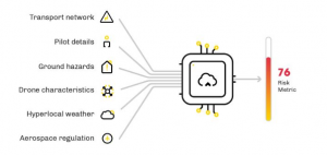
Flock Enterprise is powered by Flock’s proprietary Risk Intelligence Engine, which analyses and prices real-time drone flight risks on an individual basis. High-risk drone flights (such as those undertaken in densely populated areas, or during bad weather) receive higher risk metrics, and therefore higher insurance prices. Safer flights (such as those undertaken in rural areas, or during optimal weather conditions) are met with lower prices. Individual flight prices are then seamlessly aggregated to calculate a monthly premium, which fairly reflects the actual usage and risk profile of a drone fleet in a given month.


Flock’s Risk Intelligence Engine


Unique to Flock’s innovative insurance model are the granular risk insights that are shared with customers. By using these insights, enterprises can proactively improve safety standards across their fleets and reduce their insurance premiums as a result.

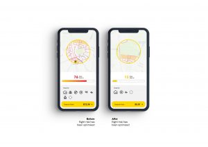
Flock has already demonstrated the financial and safety benefits of its risk analysis technology. After launching Europe’s first Pay-as-you-fly drone insurance product in conjunction with Allianz, Flock has analysed and priced the risk of more than 500,000 drone flights. By clearly visualising these risks in Flock’s app, thousands of drone pilots have been empowered to optimise towards lower-risk flights, and reduce their policy price by an average of 15% as a result.


Thousands of pilots have used Flock’s Pay-as-you-fly mobile app to pinpoint where and when it is safest to fly.


White paper:


In conjunction with the launch of Flock Enterprise, Flock has published a white paper detailing the use of real-time data in insurance and risk management. To access the white paper for free, visit Flock’s website.


Ed Leon Klinger, Flock CEO said: “At Flock, we believe that insurance can be so much more than a piece of paper. We’re using cutting edge data science to not only unlock fully digital, customer-centric insurance products, but to completely transform the way organisations understand, manage, and mitigate their own risks.”


He added: “Our Pay-as-you-fly insurance policies have now helped thousands of small businesses fly safer. With the launch of Flock Enterprise, we’re making our technology available to some of the largest drone companies in the world. We’re delighted to be enabling Texo and others to expand the use-cases of our technology and theirs.”


Graham Brown, Chief Executive Officer, ARPAS-UK said: “Flock have created a new level of insurance for companies who want to access real-time data when assessing their flights. This will support both pilots and Managers in understanding risks involved to help them make the best possible decisions.”


David Williams, Chief Operating Officer, Texo iHUB said: “We see Flock more as a partner than as an insurer. Rather than simply offering us a price, they actively help our pilots and risk managers identify and minimise the organisational risks we’re undertaking.”

He added: ‘We’re excited to work closely with them moving forward to really push the boundaries of what’s possible in the commercial drone industry.”


__________________________


Notes to editors


Additional information about Flock:


  • Flock is a London-based, VC- and Government-backed insurtech startup operating at the cutting edge of the data analytics and insurance spaces. Flock began its journey as an academic research project in 2015. Having partnered with Allianz, the world’s leading aviation insurer, Flock now insures 30% of commercial drone businesses in the UK with its suite of fully digital, data-driven drone insurance and risk-management products. These range from Pay-as-you-fly policies for SMEs, up to usage-based enterprise insurance for connected drone fleets.
  •  Flock is initially launching Flock Enterprise to UK-based drone organisations (with their global flights covered). Flock Enterprise provides bespoke equipment insurance for fleets of any size and drone type, with flexible liability limits (up to £25M). Flock is planning to roll out Flock Enterprise to international drone organisations in the future.
  • Flock is now working with global insurers to capture new markets entirely and make the world a safer, smarter place with its technology. Flock’s Risk Intelligence Engine equips insurers to accurately identify and quantify risk in an entirely new way, allowing them to confidently build and launch never-before-seen products in new industries.


Additional information about Texo


  • Texo provide fully integrated survey and inspection services, delivered by the most advanced fleet of drones and associated sensor payloads. The company supports sectors such as: critical infrastructure, Oil & Gas, Nuclear, Renewables, Construction and Utilities allowing clients to make highly informed engineering decisions, based on the very highest levels of safety, efficiency and accuracy.
  • Texo hold the UK’s most comprehensive set of congested area commercial flight permissions ever awarded by the UK Civil Aviation Authority (CAA).

Flockcover.com


SAM IS ....
Drones and heritage chiefs in battle for Britain’s skies

They are the most spectacular monuments, landscapes, castles and stately homes that Britain has to offer. And for a growing band of amateur drone pilots, their majesty is only increased when viewed from the air.

The enthusiasm of a new generation of drone operators for bird’s-eye photos is not shared by the owners of sites they wish to photograph. Yet there appears to be little that those entrusted to look after landmarks can do to stop the buzzing overhead.

English Heritage, which is responsible for Stonehenge, has banned the use of unmanned aerial vehicles over all its sites without approval, saying that they pose a risk to sensitive historic sites as well as to people visiting them. It has recorded about 250 unauthorised drone flights over the past three years.

Read more… 

Greg Hurst for The Times 25/1/2019

SAM IS ....
Drone Evolution wins Sir Michael Moritz Start-Up of the Year Award

Caerphilly-based start-up Drone Evolution have been announced as the 2019 winners of the Sir Michael Moritz Start-Up Award at the Welsh Technology awards organised by ESTnet.  Drone Evolution are also an ARPAS-UK member.

The Sir Michael Moritz Tech Start-up Award (sponsored this year by GoCompare) recognises those who have achieved success in a short space of time and have the potential to grow and thrive in the near future. The judges were impressed with the application of technology that Drone Evolution have planned as well as the potential for the business to grow very quickly. After only six months of operation, the company’s service arm has already won a contract delivering asset management for telecoms masts around the UK and is providing 3D mapping, topography and marketing services for clients such as architects, developers and historic buildings managers.

The company’s products division has registered its first IP protection for a tethered system that will allow almost any drone to stay in the air for extended periods of time, powered via a ground station. Representing a significant improvement on the 20 minutes that a typical drone lasts, it is already attracting interest from the military and emergency services.

Co-Founder and Communications Director Toby Townrow said, “We are absolutely thrilled to receive this award. Previous winners have gone on to achieve great things and we see that the increased awareness will really help us achieve our goals for this year and beyond. There were a huge range of nominees across a wide range of tech sectors so this does come as a surprise. We’re also happy to use this award to fly the flag for positive uses of drones here in Wales and across the UK.”

The company will be launching some new products at DSEI in September and will be working with some well-known partners in the process.

SAM IS ....
CAP1789: The EU UAS Regulation Package – Outline

EU exit

Please note that, in the event of the UK leaving the EU without a negotiated agreement, some CAA website content and application forms may continue to carry the EASA logo or reference the EU or EASA rather than the UK CAA in the short term. These will be updated in due course following the UK’s departure from the EU. In the meantime, the guidance provided and the application forms accessed via the CAA website portal will continue to be valid.

CAP1789 – The EU UAS Regulation Package – Outline

Description:This document provides an outline of the newly published EU unmanned aircraft regulations along with a simple explanation of the general intent behind the key parts of the regulations and our outline plans for their implementation within the UK next year. It is intended to be used as an aid to reading and understanding the regulations themselves.

CAP1789 EU UAS Regulations-Guidance

http://publicapps.caa.co.uk/modalapplication.aspx?appid=11&mode=detail&id=9135

21/6/2019

SAM IS ....
ARPAS-UK Members Meeting: Wales & Midlands

Date: 26rd  September 2019

Venue: Walsall Wood Football Club

Open to members and non-members.


Event information


SAM IS ....
Wainfleet Flooding: Police Drone Monitoring

Late last week, the equivalent of about two months’ rain fell in two days, forcing 1,000 people out of their homes – about half the population – and flooding nearly 130 properties in the Wainfleet, Lincolnshire, UK.

As the rain fell, it became crucial to the Environment Agency and the Emergency Services to map the flooding and monitor the River Steeping. The River broke its banks on Wednesday 12th June.

More than 340 tonnes of ballast were dropped by RAF helicopters to shore up a breach in the wall of the River Steeping after it burst its banks on Wednesday.

High-volume pumps were deployed by the Environment Agency to move the water away from the local area and into the catchment area for the River Haven near Boston.

However, more rain is expected on Tuesday and Wednesday and the MET Office has issued a yellow weather warning.

Lincolnshire Police have operated drones for a few years now, to support their more traditional means of policing Lincolnshire. They have been used to great effect, locating missing persons, finding those who run from RTCs, assisting with crowd dynamics, burglaries, and more. They also have thermal imaging capabilities, which are ideal for night flying too. They are also conducting Beyond Visual Line of Sight (BVLOS) training for many scenarios too.

On June 15th at 16:15, an Emergency Restriction of Flight was put in place in the area of Wainfleet and Thorpe Saint Peters from the surface to 2000ft. This applied to all manned and unmanned aircraft. The UK’s Civil Aviation Authority were able to put this into effect with only 30 minutes warning. Those needed to support the operation were given authority to fly, while all others were ordered to stay away to ensure the safety and smooth running of the operation.  We will see these quick notice NOTAMs (Notice to Airmen) appear more often as drones usage increases too.

The Linolnshire Police Operators monitored the situation all through the night and all the next day.  The ERF was lifted on Monday 17th June at 11am.

Lincolnshire Police use the Aeryon R60 Skyranger, which – as you may have worked out – can fly in the rain and relatively high winds.


While much of this could have been done by helicopter, and they were used by the RAF to deposit the sandbags, drones offer a highly cost effective means to monitoring, meaning resources are stretched further to provide better support to the people of Lincolnshire.


Congratulations to a well run operation and thank you for all your hard work.  #DronesForGood


Lincolnshire Police Drones Twitter: @LincsCOPter


SAM IS ....
DJI Sets The Record Straight On Incorrect Speculation Presented During U.S. Senate Hearing

DJI, the world’s leader in civilian drones and aerial imaging technology, today sent a letter to the U.S. Senate Commerce, Science, and Transportation Subcommittee on Security to set the record straight on incorrect claims presented during a hearing last week.

In the letter, DJI responds to hearing witnesses’ incorrect speculation about the company’s data security practices, writing: “the unsubstantiated speculation and inaccurate information presented during [the] Subcommittee hearing will put the entire U.S. drone industry at risk, causing a ripple effect that will stunt economic growth and handcuff public servants who use DJI drones to protect the public and save lives.” DJI adds: “DJI drones do not share flight logs, photos or videos unless the drone pilot deliberately chooses to do so. They do not automatically send flight data to China or anywhere else. They do not automatically transmit photos or videos over the internet. This data stays solely on the drone and on the pilot’s mobile device. DJI cannot share customer data it never receives.”

The full text of DJI’s letter to the Subcommittee is available at this link.

SAM IS ....
IMechE UAS Challenge 2019

16-18 June, 2019

Snowdonia Aerospace Centre, Llanbedr, LL45 2PX


The UAS Challenge (Unmanned Aircraft Systems Challenge) is the IMechE leading annual student competition in the aerospace sector.

It leads the way in promoting value and cohesion within the industry, providing unique opportunities to universities, their teams, the individual participants and of course for our partnering organisations.

Launched in 2014 with the key objectives of developing professional engineers and inspiring the next generation, the Challenge is now in its fifth year. Each annual Challenge cycle kicks-off in October, ending with a final event in June the following year.

Teams of undergraduates from all over the world take part in the Challenge. They undertake a full design and build cycle of a UAS with specific mission objectives. The Challenge bridges the gap between academia and industry in developing applied UAS-related activities, providing the perfect opportunity to strengthen links with industry, other universities and enhance employment opportunities for graduates in the aerospace sector. See competition rules.

The Challenge provides several categories of awards:

Grand Champion

Highest aggregate score from the PDR, CDR, A0 poster and the Flight Demonstration

Runner Up

2nd highest aggregate score from the PDR, CDR, A0 poster and the Flight Demonstration

3rd Place

3rd highest aggregate score from the PDR, CDR, A0 poster and the Flight Demonstration

Innovation

Most innovative concept taken through to flight demonstration.

Design

Entrant with a well-structured design approach, the most elegant and well thought through design, as described through the Concept Paper, PDR and CDR stages that fully meets all the requirements laid down in the rules.

Scrutineer’s

Best presented UAS that is fully compliant with the competition rules.

Safety & Airworthiness

Entrant developing the best combination of a well-articulated safety case, with evidence that safety and airworthiness have been considered throughout the design and development stages, the UAS exhibiting practical safety features, and demonstrating safe operation and team behaviour.

Business Proposition

Entrant with the most promising business and marketing case presented to a panel of sponsors during the flight demonstration event, reflecting a well-articulated understanding of the market and good alignment of the UAS capabilities and cost projections with the target market.

Most Promise

Entrant which couldn’t quite make it all work on the day, but where the team showed most ingenuity, teamwork, resilience in the face of adversity, and a promising design for next year’s competition.

Highest placed new entrant

Highest mission scores for a university that has not previously taken part.

Media & Engagement

Team which engages most effectively with local media, schools, and social media to promote participation and engagement with the Challenge.

Our best wishes to the 2019 Teams!

  1. Wrexham Glyndwr University – Team B-G-F-E
  2. University of Dundee – Haggis Aerospace
  3. University of Huddersfield – Sparrow Hawk
  4. University of Huddersfield – Harrier Hawk
  5. University College London – Team Newton
  6. University of Southern Denmark – Team SDU Eagles
  7. University of Southampton – Team Volta
  8. University of Southampton – Team Eagle
  9. University of Southampton – Team Colibri
  10. University of Sheffield – Project HEX
  11. University of Bath – Team Bath Drones
  12. Sheffield Hallam University – Team Hallam
  13. Cambridge University – Team CUUASS
  14. Loughborough University – Osiris
  15. Cranfield University – Team Blackbird
  16. Warwick University – Warwick Drone
  17. Ghulam Ishaq Khan Institute of Engineering Sciences and Technology, Pakistan – Team Foxtrot
  18. University of Moratuwa, Sri Lanka – Moira Avions
  19. Imperial College London – Project ICAV
  20. Queen’s University Belfast, team FLYTANIC
  21. University of Sheffield – Team Volaticus
  22. Brunel University – Team Brunel
  23. University of Twente, Netherlands – Team A3T
  24. National University of Sciences and Technology, Pakistan – Team NUST Air Works Beta
  25. National University of Sciences and Technology, Pakistan – Team NUST Air Works Alpha
  26. University of Hertfordshire – UH Valkyrie
  27. Coventry University – Team Phoenix
  28. DHA Suffa University, Pakistan – Team DSU Bur’raq
  29. University of Surrey – Team Peryton
  30. University College London – Team Nova
  31. Concordia University, Canada – AHS Stingers
  32. Queen’s University Belfast – Hibernica Liberandum

For more information: https://www.imeche.org/events/challenges/uas-challenge

Follow on:

Facebook  & Twitter


SAM IS ....
Drones central to £7.8m plan to transform UK rail network

New funding for innovative work on the UK’s rail network has been allocated to help them become more efficient, greener and cleaner.

The £7.8m allocation will be shared between a number of projects to help achieve this ultimate objective.

As part of the announcement from Innovate UK and the Department for Transport, it outlines how drones could play a central role in the work.

It details how drones being used to inspect railway infrastructure along with hydrogen trains and a sound bending wall to cut noise pollution are among 24 winning projects in the third round of the First of a Kind competition.

Commenting, rail minister, Andrew Jones, said: “The First of a Kind competition has consistently produced truly innovative projects developed for the benefit of passengers, helping to drive forward a greener, cleaner and more efficient rail network. This government is also investing £48 billion to modernise our rail network over the next 5 years, ensuring people have the safe, frequent and punctual journeys they deserve.”

He continued: “Among the successful projects is 4Silence’s plan to develop a noise-reducing wall that works by diffracting sound waves from passing trains upwards. This makes it as effective as a barrier 3 times its height.

“Another scheme being supported is Amey VTOL’s development of a drone system that could carry out track inspections from the skies. This would avoid the need for people to set foot on railway infrastructure.

The first round of First of a Kind was launched in 2017 and saw 10 projects win a share of £3.5 million to develop ideas to improve passenger experience and demonstrate tomorrow’s trains.

The second round focused on schemes aimed at cutting the carbon footprint on the UK’s railways and enhancing stations for passengers. This saw another 10 projects offered a share of £3.5 million.

AmeyVTOL set up a Joint Venture in the summer of 2016, with the Flying Wing drone. It carries ground penetrating radar, high definition video and still, infrared, thermal and light detection and ranging sensors.

The Flying Wing can take off and land anywhere, travel long distances at speeds of up to 60km/h and change direction to map the same route over and over, regardless of weather conditions. It also captures data in real time and streaming it live to a data processing engine.

At the time, AmeyVTOL service development director Richard Butterfield said: “Using this cutting-edge technology to inspect the vital infrastructure that we all rely on is a world first. It will change the way we inspect assets forever; allowing us to assess at the touch of a button, make real-time recommendations and potentially save millions of pounds for our clients.”

From Commercial Drone Professional and other sources.

13/6/2019