SAM IS ....
CAP 1861 – Beyond Visual Line of Sight in Non-Segregated Airspace

Regularly operating unmanned vehicles beyond the visual line of sight (BVLOS) of their operator is a key requirement to maximise the benefits that this technology can deliver.

This new Innovation Hub guide introduces the fundamental principles of operating safely beyond visual line of sight, and describes the challenges that must be tackled in order to unlock the full potential for everyday flying such as inspection of infrastructure and deliveries.

191126_CAP 1861 – BVLOS Fundamentals – UAS Innovation

The UK Civil Aviation Authority has published its first guide aimed at supporting the industry to make unmanned aircraft (drone) flights beyond the visual line of sight of the operator (BVLOS) an everyday occurrence. This would significantly change how unmanned aircraft are used in the UK.

Currently, BVLOS flights require permission from the Civil Aviation Authority and can only occur in specific, restricted cases. Normalizing BVLOS will continue to push the UK forward as a world-leader in aviation innovation and technology.

  • Allowing BVLOS operations in the UK could bring huge benefits, including:
  • Drone parcel delivery from a distribution centre to a customer
  • Long-distance aerial surveys of infrastructure such as power lines or highway construction
  • Surveillance at the scene of an accident or incident, operated from an external control centre
  • Street mapping a whole city with optical and acoustic sensors

The guide details how future BVLOS operations can be achieved through testing and technology development. They set out the need for the regulator and innovators to build, test, learn and repeat in partnership in small steps to work toward the vision of safe BVLOS operations becoming business as usual in the UK.

David Tait, Acting Head of the UK Civil Aviation Authority’s Innovation Team, said:

“Enabling everyday drone flying beyond visual line of sight is a game changer, providing the opportunity for unmanned vehicles to monitor critical infrastructure, make deliveries and support our daily lives in an efficient and environmentally friendly way.”

“We are now working closely with some of the world’s leading innovators to make these amazing possibilities a reality.”

One company involved in the Civil Aviation Authority’s innovation work is sees.ai, a Techstars-backed startup led by four seasoned founders, formerly with Arup, Apple, CERN, McLaren and hedge funds.

sees.ai is developing technology that will enable drone service operators to fly drone missions BVLOS, from a central control room, at scale. Initial focus is on closed industrial sites, e.g. construction, infrastructure, and oil & gas. Tests are planned with companies such as Skanska, Atkins and the fire service, supported by NATS and Vodafone.

John McKenna, CEO of sees.ai, said: “Under conventional visual line of sight rules, operations have virtually zero economies of scale. In contrast, a centralised BVLOS approach improves on almost every measure with scale – including quality, safety, responsiveness and cost. For end clients, our technology will unlock a service that is better, quicker and cheaper. For operators, our technology will give them a competitive advantage that increases with scale. It’s a very exciting time and we are delighted that the CAA have invited us to explore the future with them.”

This roadmap has been produced by the Civil Aviation Authority’s Innovation Team, initially funded by a Department for Business, Energy and Industrial Strategy (BEIS) grant.

25/11/2019

The CAA


SAM IS ....
PARTNERSHIP: AVY & MEDICAL DRONE SERVICE

Avy announces its partnership in the MDS consortium as its technological partner. Together we will explore the use of drones for medical services in the Dutch healthcare system.

THE NETHERLANDS HAS TAKEN-OFF WITH DRONES

The Medical Drone Service (MDS) consortium consisting of the ANWB MAA and PostNL announced their collaboration today. Along with KPN, we’re proud to be their technological partner on this journey to explore how drones can contribute to healthcare in The Netherlands.

Healthcare partners Sanquin (blood bank) and Erasmus MC (hospital & pharmacy) acknowledge the challenges of getting medical goods to patients in time now that roads are getting more congested. In the next three years we will carefully investigate how Avy’s long range wing drone operated by the ANWB MAA can be a solution for medical deliveries as illustrated in the animation below.

The capability of vertically taking-off and landing, and transitioning to forward flight, to cover long distances makes this aircraft unique in its kind. The modular payload bay can be adjusted and is easily exchangeable to transport different medical goods under strict conditions. The aircraft is designed for BVLOS flights in European airspace, resulting in a premium aircraft that is compliant with the new EASA regulations.

For more information on the Medical Drone Service visit the website https://medicaldroneservice.nl/.

In case you want to know more about Avy, our wing drone or flight operations feel free to drop us a message.

21 November 2019

Manon Taylor

for Avy

SAM IS ....
Report on Airspace4All-NATS Drone Infringement Safeguarding Research & new Drone Traffic Icon

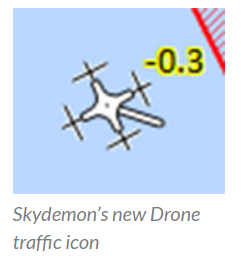
Following the publication of the report for the Airspace4All-NATS Drone Infringement Safeguarding Project, the popular GA VFR flight planning & navigation software application SkyDemon has added a new traffic icon to represent drones.

This new drone traffic icon will be displayed when traffic is detected via ADS-B which has an ‘Emitter Category’ of ‘UAV’.

SkyDemon’s aural spoken warnings have also been updated to say “drone ahead, 2 miles”, etc.

These changes will come into effect with SkyDemon’s next general release of their software.

22nd November 2019


——-

Airspace4All has published the report on the joint Airspace4All-NATS Drone Infringement Safeguarding Research.

Airspace4All and NATS, working together with City Airport (Manchester Barton), EJS-Aerial and the University of Manchester devised and conducted a research project to assess the real-world situational awareness potential of Automatic Dependent Surveillance Broadcast (ADS-B) for Unmanned Aerial Vehicles (UAVs), commonly known as drones. The research project was specifically focussed on situational awareness of drone operators and other airspace users, through the use of ADS-B technology, in the mixed UK General Aviation (GA) environment.

A flight programme was undertaken at Barton airfield with drones and GA aircraft all equipped with ADS-B transceivers (ADS-B Out & In) and traffic displays, while Barton ATS were able to observe with the aid of equipment provided as part of the separate Airspace4All GA Airfield ATS ADS-B Traffic Display Trial.

Read the full report.

21st November 2019

From Airspace4All.org

SAM IS ....
Australian police using drone technology to halve road crash delays
The Queensland Police Service in Australia will use the latest drone technology to dramatically reduce the impact of major traffic incidents and save the state millions of dollars in lost time and productivity.

The Queensland Police’s Forensic Crash Unit Aerial Mapping Project has demonstrated that using the latest drone technology it can cut crash scene mapping times in half; a considerable saving in resources. It was estimated that in one year, congestion caused by traffic incidents on Brisbane roads cost the community A$23m (US$15.7m) in lost time and productivity. One contributing factor to the time for road closure during traffic incidents was scene mapping by investigating officers of the Police’s Forensic Crash Unit. As a consequence, the project was set up to evaluate the benefits of using drone technology to map crash scenes.

So far, the results of the test program have been impressive. The Project Team conducted trials this year using the very latest drone technology, to reduce scene mapping time by approximately 50% thereby significantly reducing road closure times. Other benefits include a significant improvement in the quality and accuracy of evidence captured at the scene, with implementation being no more than current mapping methods. The Forensic Crash Unit has now deployed four operational drones with eight fully-qualified police drone pilots in South East Queensland. To further speed-up mapping operations, the drones are transported to crash sites on motorcycles to avoid traffic tailbacks, with riders piloting them within minutes of their arrival at the scene.

“This is a World First: The implementation of this innovative drone technology is a win-win-win. Roads closed for a shorter period, better evidence, and no increase in cost,” said Queensland Police Minister, Mark Ryan. “This innovative approach to policing is why the Queensland Police Service is rightly regarded internationally as a world class operation. They are always looking to technology to provide better outcomes for the community. This has been a thoroughly researched project and included consultation with key stakeholders to develop procedures and policies for the effective and safe deployment of the drone technology on motorways, highways and major arterial roads and its subsequent admissibility in court.”

“The savings economically are in the millions of dollars, the savings individually are probably in the thousands of hours.” said Michael Keating, Assistant Commissioner for Queensland Police.

BY  ON 
SAM IS ....
DJI Demonstrates Direct Drone-To-Phone Remote Identification

Simple, Low-Cost Solution Meets Government Expectations To Identify Airborne Drones

DJI, the world’s leader in civilian drones and aerial imaging technology and ARPAS-UK member, today demonstrated a direct drone-to-phone, Wi-Fi based solution to remotely identify airborne drones, pioneering an easy way for anyone with a smartphone to monitor nearby drones for enhanced safety, security and peace of mind.


DJI’s remote identification solution, developed in collaboration with industry stakeholders and regulators, broadcasts information from drones directly to off-the-shelf mobile phones using existing Wi-Fi protocols. Using a simple app, anyone within radio range of the drone can receive that signal and learn the location, altitude, speed and direction of the drone, as well as an identification number for the drone and the location of the pilot.


“Remote ID functions as an electronic license plate for drones, allowing anyone who is curious about a drone in the sky to learn more about what it’s doing,” said Brendan Schulman, DJI Vice President of Policy & Legal Affairs. “Around the world, aviation authorities have said remote ID is the key to allowing more complex drone use, and to solving concerns about safety and security. DJI’s direct drone-to-phone remote ID shows we’re committed to providing a solution in a way that is instantly usable worldwide without any additional infrastructure.”


DJI demonstrated the direct drone-to-phone remote ID system at a park in Montreal, Canada, during the International Civil Aviation Organization’s third annual Drone Enable conference. Participants used standard phones from Samsung, Google and Xiaomi to receive Wi-Fi Aware signals from a DJI Mavic Air drone and a DJI Mavic 2 Enterprise drone.


“Our direct drone-to-phone solution is an easy and elegant solution for drone pilots. They will be able to comply with Remote ID expectations simply by updating the software on many drones already in widespread use, without any extra cost or equipment,” said Javier Caina, DJI Director of Technical Standards. “In contrast, remote ID solutions that require pilots to add telecommunications equipment, subscribe to an ID service provider, connect to a cell tower or buy a data plan for their drone will create new costs and barriers for beneficial drone operations. DJI’s direct drone-to-phone solution uses the latest technological advances to make remote ID compliance as easy and inexpensive as possible.”


Aviation regulators in many countries are moving to require remote ID systems for drones as a solution to concerns about drone safety and security. The U.S. Federal Aviation Administration (FAA) has said it will release a mandatory remote ID proposal by the end of this year. The rulemaking process will take more than a year to complete, but an FAA industry committee has urged manufacturers to develop voluntary remote ID systems in the interim. The European Union Aviation Safety Agency (EASA) will impose remote ID requirements in July 2020. The app and the associated drone firmware updates used for DJI’s demonstration this week are not yet available for public use, pending further direction from aviation regulators and final publication of the ASTM International standard.


“As more drones take to the skies every day, remote ID addresses the public’s interest in understanding what’s happening in the airspace,” said Christian Struwe, DJI Policy Director, Europe. “DJI’s drone-to-phone implementation helps accomplish that by allowing drone pilots to broadcast a simple description of their flights, so anyone viewing the smartphone app can understand that they are inspecting a roof, surveying a construction site, or performing another beneficial task with a drone.”


DJI’s system was built to conform to the forthcoming ASTM International standard for broadcast drone remote ID, developed over a period of 18 months by a broad group of industry and government stakeholders. The solution uses the Wi-Fi Aware protocol for mobile phones, which allows the phones to receive and use the Wi-Fi signals directly from the drones without having to complete a two-way connection. Because it does not need to connect to a Wi-Fi base station, a cellular network or any other external system, it works in rural areas with no telecom service. In DJI’s preliminary testing, the Wi-Fi Aware signals can be received from more than one kilometer away.


“Wi-Fi is the premiere way to connect devices in the modern era, and we are pleased that Wi-Fi Aware from Wi-Fi Alliance® provides a reliable, virtually cost-free solution for drone Remote ID that can be implemented in many drones with just a software update,” said Wi-Fi Alliance, a worldwide network of more than 850 companies. “Wi-Fi Alliance will help facilitate broad industry collaboration on implementation of Wi-Fi Aware as this solution is adopted by manufacturers and policymakers.”


The new direct drone-to-phone solution is an evolution of the broadcast methodology pioneered by DJI AeroScope, the professional remote ID system first introduced in 2017 for airports, prisons, stadiums and other critical locations protected by police departments and other government agencies. AeroScope broadcasts a drone’s location, altitude, speed, direction and identification number, as well as the location of the pilot, using different radio protocols that can be received from miles away by special receivers developed for safety and security authorities who most need it. More information about how AeroScope is currently used to protect the public is available at this link.


DJI Website

13th November 2019


BBC article on the subject: https://www.bbc.co.uk/news/technology-50414108

SAM IS ....
Intel Highlights Drone Safety With Bridge Inspection Case Study

The Intel Falcon 8+ drone conducts a visual inspection of the Daniel Carter Beard Bridge in Cincinnati. In partnership with the Kentucky Transportation Cabinet and Michael Baker International, Intel used its drone technology to help inspect and analyze the eight-lane interstate across the Ohio River. (Credit: Intel Corporation)

Using drones to inspect the Daniel Carter Beard Bridge

Infrastructure inspections can be time-consuming, dangerous and costly. When the infrastructure in question is an 8-lane bridge carrying the interstate across the Ohio River, perillous working conditions and practical challenges are a given.

In a recently published case study, Intel outline how they, in partnership with engineers at Michel Baker International, used drones during a recent inspection of the Daniel Carter Beard Bridge.

Exceptional access and efficiency

Last year, Alicia McConnell, Professional Engineer and UAS Operations Lead at Michael Baker International, led a team that conducted an inspection of the bridge. The team relied upon both traditional methods and Intel’s Falcon 8+ drone.

The hardware was used alongside Intel’s Mission Control flight planning software, in a combination that saved time, money and enabled a safer and more accurate inspection process.

“The value that all the Intel products – flight planning, the actual drone system, and Intel Insight Platform – is far exceeding anything that we have used previously,” says McConnell. “It’s a value that we can’t really replace or put a value on.”

Typically, bridge inspections are carried out with teams of brave engineers using rope access and confined space access techniques. Data is often captured by hand through drawings, photos and sketches. The process can be unreliable, difficult to repeat in order to effectively monitor progress, and inefficient to communicate.

There are also the practical challenges that come with inspecting vital infrastructure that’s in use every day.

“We have a lot of restrictions, especially with traffic – we are not allowed to close lanes very often,” says Jennifer Wells, State Bridge Inspector at the Minnesota Department of Transportation.

“We noticed that inspectors weren’t getting up close to elements that they needed to see in order to get accurate data. Because of that, when it came time to rehabilitate a bridge, the inspection data wasn’t accurate. The cost of the project would go up because fixes had to be incorporated that weren’t anticipated.”

Erin Van Zee at the National Bridge Inspection Standards Bureau for the state of Kentucky, said “In the past with our pencil sketch records of the inspection, we would upload them to our database.”
Now Intel’s drone takes care of the data gathering, while the tech giant’s mission planning application and cloud software ensure inspections are repeatable and insights come to the surface quickly.
“Without this technology, it would be me looking at a piece of paper with a pencil sketch”, Van Zee continued. “Now I can look on the cloud and I can see a 3D model and get the information that we need in a shorter amount of time, more efficiently. It’s really cool.”
“Safety is #1,” says Wells. “We save time as well. And we are realizing cost savings of up to 40%. A company like Intel is proven and has a long track record of good customer service and products. That is more of a sure thing for us. Having problems with software is the last thing we need!”

Intel wants to power the workflow of the future

In the case study, Anil Nanduri, Vice President, GM Drone Group at Intel, expands on the company’s future vision and outlines how Intel will serve ‘data-centric’ businesses with drones and smart software.

“Intel is transforming its focus into data-centric businesses,” he says. “Today data is coming from our phones and other consumer devices. As we move forward, it will come from machines like autonomous robots, cars, even drones. They can produce vast amounts of data.
“Using drone technology for inspections, we can create a digital twin of the real world that we can monitor over time. People can share the data, collaborate, use AI and machine learning to automate and look for changes. This will make the workflow of the future very different from what it looks like today.”
Posted By: Malek Murisonon for Drone Life:  
SAM IS ....
Satellite Catapult: Space Enabled Agriculture 14 November 2019

The potential and opportunities for space-enabled technologies in agriculture are vast, but what is the art of the possible? On Thursday 14 November, we are hosting an event entitled ‘Space-enabled Agriculture’ on behalf of the Digital Agri-Food SIG – a one-day conference aimed at exploring space-enabled applications across agricultural supply chains and production.

Through interactive panel sessions and collaborative brainstorming, we will explore:

  • The role of ubiquitous connectivity in agriculture now and into the future
  • How geospatial intelligence can add value to farming businesses
  • What future space-based solutions are required to solve some of the industry’s biggest challenges.

Delegates from across the agricultural and space sectors will have the opportunity to learn about each other’s industries, the barriers to technology and opportunities to collaborate for the future.

Confirmed speakers include:

  • Simon Pearson – Director – The Lincoln Institute of Agri-Food Technology
  • Clive Blacker – Head of Business Development – Map of Agriculture
  • Steve Keyworth – Director – Environment Systems
  • Ben Ramsden – Partnership Manager – Digital Catapult
  • Ian Bailey – Director of Rural Research – Savills
  • Harry Wilder – Head of Agronomy – Barfoots
  • Dr. Matthew Smith – Chief Product Officer – Agrimetrics
  • Paul Febvre – CTO – Satellite Applications Catapult

Event Agenda

To view the Space-enabled Agriculture event agenda, click here.

To Register

Follow the links

More Information

For more information on the Space-enabled Agriculture event, email Marketing@sa.catapult.org.uk

SAM IS ....
Homes UK

The show takes place on the 27th – 28th of November is the UK’s largest and most senior-level event for the residential accommodation sector. It will be welcoming 6,000 buyers and major stakeholders to the event at London ExCeL to discover innovations in the way we design, deliver and maintain high-quality homes for all.

  • 6,000 senior decision makers and qualified buyers from Housing Associations (all of the G15), Local Authorities and Private Developers will be attending the show.
  • Over 76% of attendees in 2018 had purchasing responsibility of over £500,000.
  • New to 2019, HOMES UK will be delivering content on Student Accommodation, Later Living and Build-to-Rent. Attracting procurement teams, estate managers and specifiers.30%


For more information on the 30% discount to exhibit, go to the Members Area.


https://homesevent.co.uk/home

SAM IS ....
Mechanics’ Institute: Drones and robots used as Swindon council bids to restore derelict building

Drones will be used this week to assess the size of the restoration job at the Mechanics’ Institute, which has been unused since 1986.

DRONES and robots are being be used to assess the state of one of Swindon’s most iconic heritage buildings.

This week, drones will fly high-tech cameras into the Mechanics’ Institute to carry out a condition survey of the Grade II* listed building.

Swindon Borough Council is looking for ways to restore the building, which closed in 1986 and has lain derelict ever since. It is working in partnership with Historic England and the Mechanics’ Institution Trust to breathe new life into the Railway Village, with a Heritage Action Zone launched this year.

“Working with Historic England and the Mechanics’ Institution Trust is vital. We have a plan, we are making progress and this condition survey is a significant step forward.

“Drone technology will allow us to get a really good look at what we are dealing with and the professionals will use the high definition video and scans to estimate the likely cost of restoration and provide a permanent, reviewable record of the state of the building today.”

The survey has been commissioned by the council and funded by ARPAS-UK Member, Historic England.

The Mechanics’ Institute was built by the Great Western Railway in 1855 to provide a place for recreation and education for railway workers. It included a theatre and a library, among other amenities.

Since 2003 it has been owned by Forefront Estates Ltd and its eventual renovation is a key priority for the council and its partners.

Rebecca Barrett, regional director for Historic England in the south west, said: “At this stage we need to find out how safe the Mechanics’ Institute is, and to understand more about its physical condition.

“As the building is currently out of bounds, drone technology allows us to get the information we need quickly and safely.

“It’s a vital step as we work closely with others to think imaginatively about the future of the building.”

Chair of the Mechanics’ Institution Trust David Thackray, said: “The Trust is very pleased that we are soon going to be able to fully evaluate the structural condition of the building and we look forward to seeing the results in the near future.”

5 November

Swindon Advertiser

SAM IS ....
DASA awards £2m contracts to counter hostile drone threats

Funds will develop new technology to tackle rising security risks posed by Unmanned Air Systems

DASA has announced suppliers awarded £2m for counter drone innovations

The Defence and Security Accelerator (DASA) can today announce it has awarded nearly £2m to develop new capabilities to detect, disrupt, and defeat the hostile and malicious use of drones.

Eighteen bids have been funded as part of the Countering Drones competition launched earlier this year by the then-Defence Secretary.

Among the proposal being developed are methods for detecting 4G & 5G controlled drones, cutting edge applications of machine learning and artificial intelligence for sensors to automatically identify UAVs, and low risk methods of stopping drones through novel electronic defeat or interceptor solutions.

The competition, run by DASA – the MOD’s innovation hub – on behalf of Defence Science and Technology Laboratory (Dstl), is the latest stage in Dstl’s ongoing research programme into countering unmanned air systems (UAS) which has been running for ten years.

The competition has also been supported by the Department for Transport and NATO to counter the rapidly evolving threats from UAS.

David Lugton, competition technical lead, said:

The introduction of Unmanned Air Systems (UAS), often referred to as drones, has been one of the most significant technological advances of recent years and represents a shift in capability of potential adversaries.

The threat from UAS has evolved rapidly and we are seeing the use of hostile improvised UAS threats in overseas theatres of operation. There is a similar problem in the UK with the malicious or accidental use of drones becoming a security challenge at events, affecting critical infrastructure and public establishments; including prisons and major UK airports.

There was a very high level of interest from industry with over 90 bids from a wide range of organisations from micro businesses, small and medium-sized enterprises, large defence firms and academia.

This led to a doubling of initial funding from around £1m to around £2m being awarded to organisations in Phase 1.

The first phase of this competition is intended to demonstrate proof of concepts that can be further developed and integrated during later phases.

Phase 2 is planned to launch next year with a focus on developing and maturing successful research into integrated solutions

The 18 projects funded around £100,000 each are:

  • Airspeed Electronics Ltd – to develop an artificial intelligence detection system which uses acoustic sensors.
  • Animal Dynamics – to develop UAS swarm system to detect and neutralise.Unmanned Air Vehicles (UAV) by employing peregrine falcon attack strategies.
  • Autonomous Devices Limited – to develop interception technology.
  • BAE Systems Applied Intelligence Ltd – to develop electromagnetic defeat of UAS.
  • BAE Systems Applied Intelligence Ltd – to develop passive radar for detection of UAVs.
  • Cubica Technology Ltd – to develop an automatic recognition and targeting system of UAVs from large distances.
  • MBDA UK Ltd – to demonstrate an integrated system to detect, track and intercept hostile drones.
  • Northrop Grumman – to develop UAS defeat using cyber and sensor vulnerabilities.
  • Northumbria University – to develop anti-swarm drone technology.
  • PA Consulting – to develop a detection system against cellular controlled UAS.
  • Plextek Services Limited – to develop detection and signal jamming capability for UAS.
  • Plextek Services Limited – to develop miniature Counter-UAS radar.
  • QinetiQ – to develop a drone tracking system in complex environments.
  • QinetiQ – to develop a ‘hard kill’ for disrupting the UAV’s on board electronics.
  • RiskAware Ltd – to develop an automated drone identification and target tracking system.
  • Thales UK – to develop a machine learning for Counter-UAS radar.
  • University College London – to develop signal processing and machine.learning algorithms to identify drones in areas highly populated by birds.
  • An additional proposal, subject to contract.

Phase 1 of the competition is due to run until summer 2020.

DASA and Dstl will be hosting a collaboration day for the Countering Drones competition on Thursday 28 November 2019 in London.

Representatives from industry and academia interested in making collaborative bids for Phase 2 of the competition can register their interest in attending the event here.

Note that numbers at the event are limited and those who express an interest will be selected to attend depending on their skills and experience.