SAM IS ....
AmeyVTOL trials UK first ‘beyond visual line of sight’ drone inspection

AmeyVTOL has successfully demonstrated the first drone inspection of UK infrastructure to go beyond visual line of sight (BVLoS).  

During the demonstration, the VTOL flying wing surveyed an area of 2km autonomously and out of the sight of the pilot. Previous to this, drone inspections were limited to flight within visual line of sight (WVLoS) and as such, could not go further than 500 metres from the pilot.  

The successful trial opens up significant possibilities for BVLoS inspections of long linear infrastructure such as roads, railways and overhead power lines. Not only does BVLoS save time and massively reduce inspection and survey costs, it also increases the quality, volume, and repeatability of data – enabling better asset management decisions and more efficient maintenance.  

Most importantly, it also enables inspections and surveys to be undertaken without people needing to work alongside a live railway, removing ‘boots from ballast’.  

The success was made possible through AmeyVTOL’s innovative VTOL Flying Wing that can fly up to 100km on a single charge due to a unique hybrid design and an optimised energy system. Preparation and execution of the trial was made possible through AmeyVTOL’s state of the art operational control centre which enables the planning, simulation, and remote monitoring of BVLoS drone operations. Advanced communications and simulation capabilities were developed in partnership with world leader Collins Aerospace.  

Speaking on the announcement, Alex Gilbert, Managing Director, Amey Consulting said: “We are delighted to have successfully trialled a UK first for asset management. Through our collaboration with SME VTOL technologies we have developed a genuine innovation that could transform inspections and surveys for asset owners in both the public and private sector. Being able to go beyond visual line of sight will not just provide safer, more effective inspections but it will empower asset managers with increasingly reliable data, resulting in informed, intelligent decision making.” 

The demonstration project was part of a government-sponsored Rail First of a Kind (FOAK) programme promoted by Innovate UK through the Small Business Research Initiative (SBRI). SBRI is designed to bring together government challenges and ideas from businesses to create innovative solutions and was instrumental in enabling the demonstration of BVLoS operations. 

AmeyVTOL will now be offering this capability to infrastructure owners and operators who want to deliver efficient and repeatable asset safety and condition inspections, and topographical surveys, without placing people in hazardous environments. 


30th April 2020

AmeyVTOL

SAM IS ....
The stealthy little drones that fly like insects

ARPAS-UK Member, Animal Dynamics’s Chief Executive, Alex Cacchia talks about the insect inspired drones the company makes in this article by the BBC.


The article looks at how dragon flies inspired the team to crack the challenge of using flapping wings to power a drone, as well as mobile phone technology has been important to the company in the development of the drone.

“A dragonfly is an awesome flyer” says Alex Caccia, “It’s just insane how beautiful they are, nothing is left to chance in that design. It has very sophisticated flight control.”

Animal Dynamics


27 April 2020


SAM IS ....
Delay to the applicability date of EU UAS Regulation

Because of the ongoing disruption caused by the COVID19 outbreak, it has been decided that we will postpone the introduction of the new EU UAS Regulations within the UK by a period of at least four months.  As a result, any person involved in the operation of UAS within the UK will not be required to comply with the new requirements of Regulation (EU) 2019/947 (known as the Implementing Regulation – IR) before 1 November 2020.


Background to the delay

We are aware that the European Commission(EC) is also considering a postponement to the IR’s applicability date but the decision on this, and hence the final length of the delay period, is not likely to be made for a number of weeks yet.  We have taken the decision now so that we can provide a reasonable degree of certainty for you all, rather than continue to work towards the original 1 July applicability date and then change at the last minute.

It is quite possible that the EC may subsequently delay the applicability beyond 1 November, and we will notify you accordingly if this is the case.  Rest assured, however, that the date from which any person involved in the operation of UAS within the UK will need to comply with the IR will not be before 1 November 2020.


CAP1789 update

Our guidance within CAP1789 (The EU UAS Regulation Package – Outline) is being updated to reflect this applicability date change, along with a number of other developments since its original publication, and will be published very shortly.  The relevant dates within CAP722B will also be changed appropriately, as will the relevant aspects of the CAA Scheme of Charges.


If you have any questions about these or any other UAS related subjects, please refer to the CAA website for further updates – CAA Unmanned Aircraft  webpages

It is also recommended that UAS operators subscribe to the CAA Skywise service for further updates –  https://www.caa.co.uk/Our-work/CAA-SkyWise/

If you cannot find the answer via the resources above, you can email the CAA on: uavenquiries@caa.co.uk

Thank you and we wish you all well during this uncertain time.


CAA Skywise 27th April 2020

SAM IS ....
Drone Trials given Green Light by Secretary of State for Transport

Yesterday during the Covid19 daily update, UK Secretary of State for Transport, Grant Shapps gave a speech on the work his Department are doing to support the UK during the pandemic.


In it he stated: “I have given the green light to trials of drones delivering medical supplies.

Earlier this year, we awarded £28 million to Southampton and Portsmouth to develop a Future Transport Zone.

As part of that initiative, £8 million was earmarked for testing drones, and how they might be used for delivering goods in the years and decades ahead.

Of course, now we have an urgent need, so we’re making use of that testing programme as part of our response to COVID-19.

As a result, I have fast-tracked trials to begin next week to carry medical supplies and equipment to St Mary’s Hospital, near Newport on the Isle of Wight.”


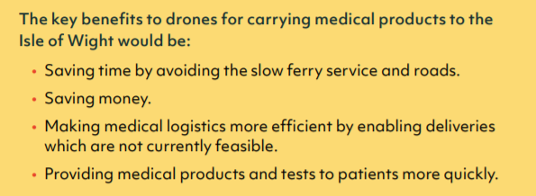
This builds on the Nesta Flying High Challenge, which looked at medical drone delivery between Southampton and the Isle of Wight, and which found the key benefits to this project to be:

From the Nesta Flying High Challenge Report: July 2018

The Isle of Wight is the second populous area, after Northern Ireland, not to have a fixed link to mainland Great Britain. The Solent is a barrier to people and goods, with relatively slow and expensive ferries providing the main connectivity.


This new drone delivery project, as part of the Future Transport Zone, will look to the future, while at the same time providing much needed medical supplies now. One of the great advantages at this current time is that drones will provide a disconnect between people, keeping those involved at much greater than social distances.


ARPAS-UK Members, Consortiq, are involved in this project, alongside the University of Southampton Transportation Research Group and Unmanned Systems Department, Windracers and DronePrep.


24 April 2020

Grant Schapps Covid19 Update

Vital Supply Routes Government Update

SAM IS ....
Blue Bear successfully demonstrates drone swarm as part of

Blue Bear Systems Research Ltd, in Bedford, has successfully demonstrated a fully autonomous suite of multiple drone swarm assets, under Beyond Visual Line of Sight (BVLOS) conditions as part of the National Beyond visual line of sight Experimentation Corridor with partner ARPAS-UK Member, Cranfield University.

This technology enables complex drone operations, where multiple assets are able to carry out simultaneous tasks, controlled by a single user, to create a swarm effect.

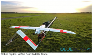
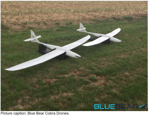
The five fixed wing drones clocked up 15 hours of flying time, over four days, in challenging weather conditions. The swarm comprised a combination of Blue Bear’s own Redkite and Cobra fixed wing systems, which flew multiple, simultaneous, sorties from a test range in the North West of England.

The drones were equipped with the latest Automatic Dependent Surveillance-Broadcast (ADS-B) technology, and the airspace was managed by Blue Bear’s airspace deconfliction software. All of the assets were controlled by a single operator from Blue Bear’s Mission Command Control System (MCCS).

Ian Williams-Wynn, Managing Director of Blue Bear Systems, said: “This is an exciting development for us, proving our ability to operate multiple drones, simultaneously, using the latest Blue Bear technology to deliver a swarm effect under BVLOS conditions.”

Yoge Patel, CEO of Blue Bear, added: “As agile innovators, this, once again, proves that we are able to develop game-changing capability rapidly.”

NBEC is a collaboration between Cranfield University and Blue Bear Systems Research Ltd that aims to create an experimentation corridor that will enable drones and unmanned aircraft to fly in the same airspace as manned aircraft.

Blue Bear executed three-kilometre Extended Visual Line of Sight (EVLOS) race track flights within the Cranfield Air Traffic Zone, utilising their Blackstart Unmanned Aerial System (UAS) towards their facility in Oakley. Regulations currently require drones to operate within visual line of sight of the operator at all times. Under EVLOS conditions, observers are used to maintain the line of sight while providing situational awareness to the operator.

The NBEC partners believe the key to future drone operations is not segregation, but unification ensuring fair and equitable use of airspace for all. NBEC will provide a safe, managed environment for drone and unmanned aircraft experimentation which will work towards their integration into controlled and uncontrolled airspace.  The aim is to see the corridor eventually stretch across Bedfordshire from Blue Bear’s headquarters in Oakley to Cranfield University’s airport.

Ian Williams-Wynn, Managing Director of Blue Bear, said: “When fully operational, the NBEC will be operated with Blue Bear and Cranfield running their respective systems, and will create an environment that allows other companies to come and test their UTM (Unified Traffic Management) concepts in a safe, managed environment.

“These initial flights, enabled us to provide Cranfield Airport with reassurance from an operational safety perspective that the systems Blue Bear had developed and put in place are appropriate and compatible with Cranfield Airport operations.”

Professor Iain Gray, Director of Aerospace at Cranfield University, said: “The Government’s new aviation strategy green paper highlights the exciting potential of modernising the UK’s airspace. These initial flights, mark an important step in the realisation of NBEC, which will be a national asset that will support the journey to the creation of a Unified Traffic Management system.”

The Civil Aviation Authority (CAA) recently hosted the NBEC Team at its London headquarters, and provided the team with support and encouragement on their project and their staged risk, managed approach. Workup flights will be continuing at both ends of the NBEC Corridor throughout 2019.

During this first phase of testing, the Cranfield Air Traffic Zone was cleared of manned aircraft, to enable the project team to establish the principles for future integrated NBEC operations.

22nd April 2020


SAM IS ....
CAA Podcast: Social Licences for Aviation Innovators

The innovation sector will play a key role for the aviation industry when the time comes for the recovery from COVID-19 to commence.

In our latest podcast, our innovation team discuss how vital social licences are, particularly for new innovative industries.

With Jonathan Nicholson, Assistant Director of Communications, and Angela Lynch of the CAA Innovation Team.

SAM IS ....
Skyports is accepted into the CAA’s Innovation Sandbox

Drone delivery service provider Skyports has announced today that it has been accepted into the UK Civil Aviation Authority’s (CAA) Regulatory Sandbox to trial beyond visual line of sight (BVLOS) flights in non-segregated airspace.

The Regulatory Sandbox is a programme established by the UK CAA to create an environment where innovation in aviation can be explored in line with UK CAA core principles of safety, security and consumer protection.

Skyports, which specialises in operating end-to-end drone deliveries within the medical, e-commerce and logistics sectors, and the UK CAA will explore how regulatory approvals can be granted for drones controlled out-of-sight of the remote pilot to be flown safely within airspace that is shared with other aircraft, which is vital if permanent drone deliveries are to become a reality.

Duncan Walker, Chief Executive Officer at Skyports, said: “Using drone deliveries within supply chains can create significant time and cost savings.  The current COVID-19 crisis has highlighted the role that unmanned aircraft applications can play in keeping the flow of goods moving, especially medical products, limiting human contact and supplying hard-to-reach communities.

A critical step in enabling permanent drone delivery operations is being able to operate out of sight of the remote pilot in airspace used by others. Through this game-changing partnership with the UK Civil Aviation Authority, we will be trialling the integration of our technologically-advanced unmanned aircraft in this shared airspace to demonstrate that our drone deliveries can be operated safely alongside other aircraft.”

Frédéric Laugère, Innovation Services Lead at the UK Civil Aviation Authority, said: “Regularly operating unmanned vehicles beyond visual line of sight (BVLOS) of their operator is a key requirement to maximise the benefits that they can deliver. We are delighted to start this new collaboration with Skyports and its partners, and working together to explore requirements under which regulatory approval of BVLOS operations could be granted. The public and the industry will undoubtedly benefit from the findings we generate and the insights we gain.”

Skyports Solution

During the trial, Skyports is working with leading technology partners Iris Automation and ARPAS-UK Member, Thales, and environmental partners RSK:

  • Integrating Iris Automation’s computer-vision-based Detect-and-Avoid (DAA) technology, called Casia, onto unmanned aircraft will enable Skyports’ drones to automatically understand the surrounding skies and independently react as if a pilot were on board to avoid mid-air collisions.
  • Thales will help Skyports with mission planning and flight management through its integrated unmanned aircraft system (UAS), SOARIZON, as well as provide cutting-edge, secure remote electronic identification through Thales Remote ID fitted to the drone so the aircraft can be tracked.
  • RSK will assist with applying its skills and expertise in environmental assessment, such as noise, air quality and carbon and social impact strategies.

UK CAA Regulatory Sandbox

The Regulatory Sandbox was launched in April 2019 to provide industry with the capability to test and trial innovative aviation solutions in a safe and controlled environment. Skyports joins other aviation innovators in the Sandbox, such as Amazon, Volocopter, Altitude Angel, NATS and sees.ai.


15th April 2020

SAM IS ....
Snowdonia Aerospace conduct successful medical BVLOS trials

Immediately before lockdown, a team from Snowdonia Aerospace, with partners SwiftFlight Avionics, University of Manchester and the Welsh Ambulance Service, completed a successful flight demo that showed proof-of-concept for beyond visual line-of-sight (BVLOS) delivery of a defibrillator by drone to a remote, rural location that would be difficult to reach with an ambulance in a timely fashion.


Courtesy of Snowdonia Aerospace

This is the first demo of this type in the UK and one of only a handful that have been conducted worldwide. The project was conducted at the Snowdonia Aerospace Centre, Llanbedr, North Wales, and funded by the UK Space Agency and Welsh Government under a National Space Technology Programme/Space for Smarter Government Programme to show how satellite-enabled drones could be used as part of a broader satellite-enabled network to support remote healthcare services in rural Welsh communities.


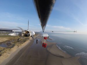
Snowdonia Aerospace are also very grateful to Schiller UK for the loan of a FRED easyport mini defibrillator. The defibrillator was delivered by parachute drop to a “first aider” and “casualty” on a remote beach. The drop point was 4.5 kilometres from the launch location and took 2 minutes 50 seconds to complete, whereas an ambulance would have taken an estimated 20+ minutes to reach the same location.


Chris Maltby in his blog says “A defibrillator is its most effective when administered within the first minute of a victim collapsing and if a defibrillator is used within the first 3 to 5 minutes, the likelihood of survival increases from 6% to 74% therefore, having a defibrillator close by really makes all the difference.”


Snowdonia Aerospace and partners are looking forward to continuing the BVLOS capability development as part of the upcoming UK Research & Innovation Future Flight Challenge and engaging with other emergency response stakeholders.


Snowdonia Aerospace are ARPAS-UK members, and also great supporters of the Institute of Mechanical Engineers’ UAS Challenge.


15th April 2020


SAM IS ....
Government announces new 10 year Public Sector Geospatial Agreement with Ordnance Survey

The Geospatial Commission is increasing the location data available to the public sector across England and Wales. Known as the Public Sector Geospatial Agreement, it will be delivered by Ordnance Survey and will start from 1 April 2020.

The agreement represents a significant investment in the Government’s world-leading geospatial asset and will see OS helping to generate economic value to the UK over ten years.

With greater freedoms to share data and better access to our new data, OS is encouraging innovation and allowing new opportunities for OS Partners, developers and public sector organisations.


It supports services such as emergency planning, building our homes, protecting our environment, supporting our transport and helping our security services to keep us safe. Today the Geospatial Commission has announced it is increasing the location data available to the public sector across England and Wales.

Any public sector organisations ranging from health and emergency services, town, parish, and community councils through to central government departments can sign up via Ordnance Survey to use the data, free at the point of use. Known as the Public Sector Geospatial Agreement, it will be delivered by the national mapping agency, Ordnance Survey and will start from 1 April 2020.

Director of the Geospatial Commission, Thalia Baldwin, said

“The Geospatial Commission was created in 2018 to make sure the UK maximises the opportunity location data presents for society, the economy and the environment. The new agreement meets our commitment to improve access to Ordnance Survey’s core data to start-ups, businesses and innovators.

It means that the public and private sectors will have improved access to the accurate and detailed mapping data they rely on today to support even more innovative, efficient and effective delivery of public services.”

Chief Executive of Ordnance Survey, Steve Blair, added

“We’re looking forward to delivering the new agreement and continuing to put OS data at the centre of decision making across the public and private sector. With this long-term investment, we can make our world-leading geospatial data even easier to access, use and share. It will enable us to capture and manage new levels of data which will support emerging markets, customers and innovation.

“Across Great Britain OS is helping to deliver value to thousands of customers, and I am looking forward to seeing how they will work with the new data to support their business and service delivery. I will be keeping an especially close eye on how new customers and start-ups innovate with the data to generate real economic value for Great Britain.”

From the 1 July 2020 businesses will be able to access, free up to a threshold, OS MasterMap data through a series of Application Programming Interfaces (APIs).

For further information, please see the Ordnance Survey PSGA home page


Published 2 April 2020
SAM IS ....
GeoBusiness 24-25 September 2020

The geospatial get-together of the year

Due to Covid-19, the date and location of the Show have changed to 24-25 September 2020 at Excel.

Are you involved in collecting or using geospatial data? Do you rely on up-to-date geospatial information? Do you research or develop geospatial technologies?


GEO Business connects the data holders and processors with the people who benefit from the applications and insight, which geospatial information provides.


For more information, visit www.geobusinessshow.com


EXHIBITION | KEYNOTE | SEMINARS | SHOWCASES | NETWORKING