SAM IS ....
Snowdonia Aerospace Airspace Change Proposal –

Snowdonia Aerospace has today launched a public consultation, open to everyone, on a proposed change to the airspace designation around Llanbedr Airfield. The consultation begins on Monday 7th December 2020 and will run for 7 weeks before closing on Friday 22nd January 2021.

The Snowdonia Aerospace Centre (SAC) is a UK centre of excellence for testing of next-generation aircraft, such as “drones-for-good”, electric aircraft, urban and regional air mobility vehicles, high altitude balloons, airships and near-space testing vehicles. The proposed airspace change is to create a permanent Danger Area that will enable SAC to further develop the site and support increased innovation in the UK aerospace sector particularly within these emerging technology markets. It is not associated with military training.

The Danger Area will be permanent in terms of its designation but will be “active” only as and when required, otherwise it will remain open to all air traffic. Ninety per cent of the operations using the Danger Area will be over the airfield or out over the sea. The proposal is part of a sustainable longterm Masterplan for Llanbedr Airfield that could contribute up to 515 jobs and £19.5m per year to the local economy once full developed.

SAC has produced a Consultation Document that explains the proposed changes, including detailed maps and environmental analysis, plus a three-page “easy-read” guide in English and Welsh. These documents and the Consultation Questionnaire can be accessed via the Civil Aviation Authority
online portal.

SAC will also be hosting drop-in sessions where members of the public will be able to ask questions and find out more about the proposal. These sessions will be held in the Main Hangar at Llanbedr Airfield, with appropriate Covid-19 measures in place:
• Thursday 10th December 2020, 10am to 4pm
• Friday 11th December 2020, 10am to 4pm (Welsh speaking available)
• Saturday 12th December 2020, 10am to 2pm

Postal responses can be submitted to:
Airspace Change
Snowdonia Aerospace Centre
Llanbedr, LA45 2PX

SAC will be happy to answer any further questions via email: da.acp@snowdoniaaerospace.com or
phone: 01341 360038.

Lee Paul, CEO of Snowdonia Aerospace said:
“We are continuing to develop complementary business opportunities at Llanbedr Aerodrome relating to aerospace Research, Development, Test and Evaluation (RDT&E).To support these operations it has now become necessary for us to seek to upgrade and formalise the current airspace
around the Aerodrome as the present provision is insufficient to meet the identified future need and risks restricting opportunities that are in the strategic economic interest of the UK and Welsh governments.

Llanbedr has long been a UK national asset for aerospace RDT&E and there has been increased demand in recent years given its ideal location for Beyond Visual Line-of-Sight (BVLOS) drone testing. These activities have been satisfied to date by the use of a Temporary Danger Area, but both customer demand and the need for confidence and reliance are now such that an application for a Permanent Airspace Change is warranted.

Moving to a permanent Danger Area will allow an increase in throughput to satisfy the market need and provide UK businesses in these sectors with a surety of being able to operate in the UK on a reactive basis. Many UK businesses have chosen to undertake their testing abroad due to the
uncertainties around availability of adequate and appropriate commercial trials environments.

Particularly during these unprecedented times it is imperative that we encourage UK innovation and support UK businesses to operate within the UK. All Dangar Areas in the UK are presently managed and controlled on behalf of the MOD with limited opportunities for commercial use and exploitation.

The establishment of a Permanent Danger Area, the first civilian managed airspace of this type and dedicated to support UK businesses in the emerging aviation sectors, will act as a catalyst to aid economic recovery and support long term sustainable jobs.


John Idris Jones, Chair of the Snowdonia Enterprise Zone Advisory Board, said:
The Snowdonia Enterprise Zone Board welcomes this consultation by the SAC and encourages local stakeholders to get involved.. This airspace designation change is a key enabler in the longer term development of the site as a location for quality job opportunities in space related research
and development and the evaluation of aircraft being developed to use low carbon fuels to meet the Government’s 2050 carbon emissions reduction target.


Cllr Gareth Thomas, Cabinet Member (Economy and Community), Gwynedd Council, said:
We have long supported the development of Snowdonia Aerospace Centre for the development of civil novel aircraft and space technologies, in order to create sustainable high-value jobs in Meirionnydd and across the wider region. We are pleased to see that steps are being taken to allow for the safe piloting of these technologies, and would encourage anybody in the community with an interest in the site to respond to the consultation.


John Whalley, CEO of Aerospace Wales, said:
Aerospace Wales is the industry association for the sector working in close co-operation with Welsh Government on future strategy. This proposal by Snowdonia Aerospace Centre is hugely important in ensuring that Llanbedr will play a lead role in the development of future flight concepts for the
benefit of both the local community, the people of Wales and the wider UK aviation community. The technologies developed will help support a more sustainable future and the creation of high value added jobs. I would encourage everyone to get involved and help shape the future.

The Consultation runs from 7th December 2020 to 22nd January 2021.

SAM IS ....
Drone deliveries and seamless end-to-end journey routing could connect UK’s rural towns and communities

What will the future of transport look like? Government seeks views on how digital innovation can help people to plan, book and pay for travel.

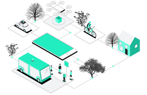
A diagram showing how digital innovation, including apps and e-bikes, will change the transport landscape of the future by making it easier for people to plan, book and pay for travel through their mobile phone.
  • call for evidence launched to find ways to boost rural transport connectivity
  • views being sought on ways that 21st-century transport – from e-bikes to drones – can be used to get people and packages from place to place more easily
  • launch coincides with publication of government response to the Future of Transport regulatory review call for evidence

Drone deliveries and digital mapping for easy-to-access walking and cycling routes could soon be a reality for people living in rural areas across the UK, following the launch of a call for evidence to help develop the government’s Future of Transport: rural strategy.

The Future of Transport: rural strategy – call for evidence, launched today (24 November 2020) by Transport Minister Rachel Maclean, looks at how the benefits of transport innovation can be enjoyed by everyone, including those living and working in rural areas.

Speaking at the Financial Times’ Future of Mobility conference, the Minister is challenging business and transport groups to help revolutionise travel in the UK’s towns, villages and hard-to-reach areas, making it easier for people to access jobs, education or healthcare.

The call for evidence will examine how to bring services and communities into the 21st century by improving transport reliability and connectivity in people’s everyday lives.

Transport Minister Rachel Maclean said:

This call for evidence will give us a unique opportunity to harness the community spirit of rural areas to understand how innovation in transport can benefit the people and communities that need it most.

Now more than ever, it is important that we use the power of transport to build back greener, and transform how people and goods move around the UK.

The distance between a person’s home and their nearest mass transport hub is often around 5 miles in rural areas, making it a major barrier to accessing public transport and services. The call for evidence looks at how linking different digital platforms together could create a more seamless experience for people, allowing them to plan, book and pay for travel all in one place, and to link journeys over multiple modes.

The call for evidence will also look at how the increased popularity of e-bikes, alongside digital-mapping technology and apps, could encourage more active travel in rural communities. This, along with better access to walking and cycling routes, could help open active routes that could otherwise go unknown.

Opportunities for drones to make deliveries in rural or isolated towns and areas are also being explored. Particularly suited to the greater distances in rural areas, drone deliveries could cut down delivery times and help to reduce pollution, allowing rural locations the potential to be a trailblazer for low-carbon deliveries.

Evidence will also be sought on how ‘micromobility’ transport methods – such as e-cargo bikes – could be integrated into rural transport networks, helping drive the changing face of rural economies and making home-based businesses more accessible to markets.

The feasibility of fully automated and passenger services operating in rural areas will also be examined, and small electric aircraft may be able to move goods and people efficiently, particularly in communities.

Today’s announcement comes as the Department for Transport also publishes its response to the Future of Transport regulatory review, which aims to create a more innovative and flexible regulatory framework that better meets the needs of both transport users and innovators.

Opens 24th November 2020

Closes 16th February 2021

Call for Evidence

SAM IS ....
Drone Harmony Select Altitude Angel as Global Map Data Provider

London, UK:  Altitude Angel, the world’s leading UTM (Unmanned Traffic Management) technology provider, today announced mission planning platform, Drone Harmony, has opted to embed Altitude Angel’s market-leading data in its flight mapping solutions.

Drone Harmony is a software company developing a data capture platform that enables enterprises to capture quality data of infrastructure assets, thus addressing the main hurdle encountered when attempting to tap into digitalisation benefits: the lack of complete, quality, and up-to-date digital databases representing the enterprise assets.

Drone Harmony will draw on Altitude Angel’s GuardianUTM system for accurate, real-time, and relevant geospatial data.

Drone Harmony‘s market-first 3D data capture platform consists of fully integrated mobile and web applications and cloud service. It is designed to be globally deployable, easy to incorporate into enterprises’ infrastructure workflow supports widely available ‘off-the-shelf’ drones.

The key enabling technology is an automated mission planning capability that exploits GIS, CAD, and shape data about the inspected asset’s geometry and its environment to generate and execute safe and optimised data capture missions in complex use cases. Its platform is the first to incorporate a full 3D working interface.

On partnering with Drone Harmony, Richard Ellis, Altitude Angel, Chief Business Officer, said: “We’re thrilled to be partnering with Drone Harmony and providing them with the richest UTM data picture, not only for Switzerland, but Europe and beyond. 

Martin Fuchsberger, Drone Harmony, founder, and Chief Executive Officer, added: “With Altitude Angel, our operators always have up to date UTM information at their fingertips, thereby ensuring safe drone flights. We are excited to continue building on this foundation, adding safety benefits for our customers, such as flight authorization (LAANC) and RemoteID services.”

ENDS

About Altitude Angel: 

Altitude Angel is an aviation technology company delivering solutions which enable the safer integration and use of fully automated drones into airspace. Through its Airspace Management platform, GuardianUTM O/S, they deliver the essential software platform which enable national deployments of U-Space compatible services, safely unlocking the potential of drones and helping national aviation authorities and air navigation service providers to establish new services to support the growth in the drone industry.  

The foundation components of GuardianUTM O/S are also available to enable third-party UTM developers to incorporate enterprise-grade data and services into their UTM solutions.  

Altitude Angel was founded by Richard Parker in 2014 and is headquartered in Reading, UK.  

Altitude Angel’s developer platform is open and available to all at https://developers.altitudeangel.com.  

About GuardianUTM: 

GuardianUTM enables drone manufacturers and software developers to connect into a rich, dynamic source of accurate, authoritative and relevant information to support geofencing, while offering enhanced UTM capabilities such as a single interface to multi-country flight authorisation. 

The system was demonstrated as part of ‘Operation Zenith’ in 2018, offering enhanced airport safeguarding and automated approvals to fly in controlled airspace. Altitude Angel is now bringing online functionality to enable drone pilots anywhere in the world to get 1-click access to controlled airspace. 

Its companion product, GuardianUTM O/S, supports all the functionality required to deliver national-grade drone traffic management capabilities to any country that wishes to safely unlock the potential of drones.

Introduction video: https://www.youtube.com/watch?v=Bd0pvUrS07g 

About Drone Harmony: 

Drone Harmony is a software company developing a data capture platform that enables enterprises to capture quality data of infrastructure assets, thus addressing the main hurdle they encountered when attempting to tap into the benefits of digitalisation: the lack of complete, quality, and up to date digital databases representing the enterprise assets.

Drone Harmony‘s market-first 3D data capture platform consists of mobile and web applications and a cloud service, all fully integrated. It is designed for easy incorporations into the enterprises’ infrastructure workflow and supports off-the-shelf, widely available drones. The key enabling technology is an automated mission planning capability that exploits GIS, CAD and shapes data about the geometry of the inspected asset and its environment to generate and execute safe and optimized data capture missions in complex use cases.

Drone Harmony’s flight planning software is available at:

1st December 2020

SAM IS ....
CAA Message to UAS Industry and Community

The UAS Unit of the UK Civil Aviation Authority is pleased to announce the following key messages to the UAS Industry and General Public. 

  1. We are working hard now to publish a new version of CAP 722 A – UAS Risk Assessment Methodology at the end of January 2021. This publication will incorporate the UK Version of the Specific Operations Risk Assessment (SORA) and improve the brevity and clarity of existing guidance. The UK CAA will begin accepting SORA based authorisation applications once this new version of CAP722A has been published.
  1. The recent publication of CAP722 – Unmanned Aircraft System Operations in UK Airspace – Guidance was a significant overhaul of the keystone policy and guidance document for UAS operators in the UK. It is to be expected that with such a large new document that there will be a few tweaks to improve accuracy, brevity and clarity. We intend to make these improvements in the second quarter of 2021. There is no plan for these improvements to change underlying policy.  Please let us know how you think we can improve the accuracy, brevity and clarity of CAP722. 
  1. The Department for Transport (DfT) is in the process of amending the Air Navigation Order (ANO) so that it reflects the applicability of the new UAS regulations. We expect to have the amendment details confirmed to us by early/mid December this year. Guidance on the ANO amendment will be published in a separate CAP as soon as possible afterwards. 

 As always, we look forward to continuing working together with the aim of increasing safety standards and providing clear guidance for all our regulated community.

On behalf of the
Unmanned Aircraft System  (UAS) Unit
Safety and Airspace Regulation Group

The Civil Aviation Authority