SAM IS ....
NHS launches UK’s first COVID test drone delivery service in Scotland


London, United Kingdom (UK), Tuesday, 23rd February 2021 – Argyll & Bute Health & Social Care Partnership (HSCP) has begun carrying COVID test samples and other medical materials on drone delivery flights between medical facilities in the Argyll & Bute region. Following a proof-of-concept phase last year, the three-month initiative, which aims to help improve COVID-19 related logistics to and from remote locations, has now been expanded and is fully operational.

The delivery drones, operated by the logistics arm of advanced air mobility company Skyports, will carry up to 3kg of critical medical supplies up to 40 miles. Cargo to be carried will include COVID-19 and other test samples, medicine, essential personal protective equipment (PPE) and COVID-19 testing kits. In a UK first, Skyports has become the first operator to receive permission by the UK Civil Aviation Authority (CAA) to carry diagnostic specimens by drone.

Using delivery drones, access to hard-to-reach areas can be improved, significantly increasing the speed of transport and reducing times in some areas of the Argyll & Bute region from up to 36 hours for a road and
ferry journey to 15 mins, while also increasing the frequency of pick- ups.
The drone delivery service will initially operate between Lorn & Islands Hospital in Oban, Mid-Argyll Community Hospital in Lochgilphead, Easdale Medical Practice in Clachan Seil and the Mull & Iona Community Hospital in Craignure.

Both a scheduled service and an on-demand service will be run, with orders able to be placed by NHS staff through an online system developed by digital consultants Deloitte. Skyports will be using the Swoop Aero drone-powered logistics platform. The vehicles will be controlled from the Skyports Operations Centre in Oban and fly automatically along predefined routes. Communication between the drone and the ground control station will be provided by Vodafone’s 4G network and satellite communications to ensure connectivity coverage is provided at all times.

The project has been funded by a joint initiative between the UK Space Agency (UKSA) and European Space Agency (ESA) Space Solutions to utilise space-enabled technology and services that can support the NHS. This project follows a successful proof-of-concept conducted by Argyll & Bute HSCP in 2020 between Lorn & Islands Hospital and Mull & Iona Community Hospital.

Duncan Walker, Chief Executive Officer at Skyports, said: “Using drone deliveries within supply chains can create significant time and cost savings. This initiative is a natural progression from our recent trials with the NHS in Scotland as we scale our operations, supporting a wider network of hospitals and medical practices as they continue to respond to the COVID-19 pandemic.

“The experience from this important initiative will put us another step closer to permanent operations from which we hope more NHS facilities could soon benefit. This project underscores the viability of drone technology as a practical way to move goods.”

Stephen Whiston, Head of Strategic Planning for Argyll and Bute Health and Social Care Partnership, said: “Argyll and Bute HSCP is delighted to once again be at the forefront of using this innovative technology to assess how unmanned drones can enhance our logistics operations and improve services for patients and clinicians in some of our most remote and island communities. This three-month project working with Skyports will provide critical evidence on the real benefits this technology can bring to the NHS not only in Argyll and Bute but across Scotland.”

Skyports are an ARPAS-UK Member.

Website: www.skyports.net * Skyports on Twitter

SAM IS ....
Prometheus drones to explore subterranean environments

Prometheus drones to explore subterranean environments

A project inspired by the sci-fi film ‘Prometheus’ is developing tiny autonomous drones that can navigate and map unexplored subterranean environments beneath the UK’s rail network.

The £2.2m project, funded by Innovate UK, is a collaboration between Headlight AICallen-Lenz and ARPAS-UK Member Thales, the Universities of Manchester, Bristol and Royal Holloway London, and stakeholder Network Rail.

Due for completion in July, the aim is to provide solutions across industries where underground exploration in harsh conditions is crucial.

Dr Puneet Chhabra, co-founder of Headlight AI, said the project came about during a 2018 Innovate UK event. Chhabra took part in a discussion with Network Rail principal mining engineer Neal Rushton, Manchester University robotics engineer Simon Watson, Royal Holloway computer science professor Sara Bernardini and Bristol University aerial robotics professor Tom Richardson.

“We showed [Neal] some of the work that we’d done and he explained that his vision was to put a circular robot down a tiny 150mm [diameter] borehole next to a railway track,” Chhabra said. “There are thousands of these mines and voids under the tracks and they are interconnected – the limitation at the moment is that they don’t know what is beyond the line of sight, they don’t know what exists and how they are connected and so they aren’t being mapped or surveyed.”

Read more…

By Melissa Bradshaw 3rd February 2021 11:23 am

SAM IS ....
Adjuster’s Perspective: How one Drone Flight saved an Insurer over £200k

blog image2nd Feb

When it comes to using tech in insurance, it can be difficult to separate the wheat from the chaff. So many claims are made about how technology will enable adjusters to be more efficient and effective but with so much noise in the insurtech space and, regrettably, a number of false dawns, it can be difficult to know who or what to trust.

But taking a conservative, defensive posture in the face of digital progress simply isn’t an option – that is a sure-fire way to get left behind. Which is why at Crawford we carefully analyse, select and trial the range of tools we believe will make a real, practical difference.

This has always been our approach to restoring and enhancing rural lives, businesses and communities and one of the most effective tools we have adopted over the last couple of years is drones.

Think outside the box:

Adjuster's perspective: One drone flight saved insurer £200K

There is an assumption that they are best utilised in flood situations or major loss property claims – basically enabling quick and safe access to areas that humans can’t easily reach. And while that is correct, the applications of drone surveys also go far beyond providing access, as we have found. We started out using drones for flood and property damage claims but recently, we have been using them for core agricultural claims and with impressive results.

For instance, we were recently instructed on an agricultural claim that arose from hailstorm damage to an oil seed rape crop. Just before harvest, the crop was hit by a storm and the hail severely damaged the fragile pods that contain the rapeseed on a large portion of the open fields.

Traditional Approach:

The traditional approach would have been to get the wellies on and measure the perimeters and walk through the entirety of each affected field in a ‘W’ fashion to cover as much of the crop as possible, assessing the severity of damage. Our findings would then be reviewed in conjunction with the combine harvester readouts to try to obtain an estimate of the loss.

Back in 2018, we had discussions with Iprosurv about hailstorm damage to oil seed rape crops and whether drone inspections could assist, and two years later, with this instruction, the perfect claim arose for a trial.

Timing:

It was fortuitous timing as Iprosurv had recently added new equipment to their drones, namely Normalised Difference Vegetation Index (NDVI) cameras. In simple terms, these cameras analyse the different light colour spectrums reflected by the chlorophyll within crop vegetation – healthy plants reflect at a different light frequency to damaged or unhealthy plants.

Open Field Claims:

We are the first adjuster in the UK to use NDVI technology on open field claims, so it was a bit of an educated leap into the unknown, but the tech not only gave us a quick and accurate measurement of the damaged crop but also the overall health and expected yield of the standing crop. This allowed us to compare the expected yield with the yield achieved and indeed the ‘expected’ yield claimed by the Insured.

Enhanced Data:

That is a level of detail we have never been able to achieve before and, for an outlay of around £2,000 for the drone survey, footage and imagery, the insurer was able to make a £220,000 saving on the initial amount claimed. While that was something of a difficult conversation with the policyholder, the rationale for the settlement offered was all there in the data. As they say, the data doesn’t lie.

Despite what anyone might think, the main motivation for any insurer in any claim is to get to a settlement that is accurate and fair – using a drone fitted with an NDVI camera allowed us to do that with pinpoint accuracy in a relatively short timeframe.

Success:

Such was the success of this, we have started exploring other uses for drone inspections and we believe that it could be of huge benefit in environmental damage, aquaculture, spray drift and forestry claims. We could even use it to analyse the health of a potato crop without having to go through the disruptive, time consuming process of digging up the field. The possibilities are almost endless.

Exciting Times:

It’s an exciting time in the world of claims with more and more digital tools playing an increasingly important role. Whilst it’s true that tech isn’t the answer to all our questions, working with the right partners and with the willingness to try new things, we’ve found that you can effectively separate the wheat from the chaff, both figuratively and literally.

Max Perris is an Agricultural Consultant for Crawford & Company

Iprosurv is an ARPAS_UK Member

3 February 2021

SAM IS ....
Network Rail Appoints Dronecloud to supply Enterprise level Drone Management Platform


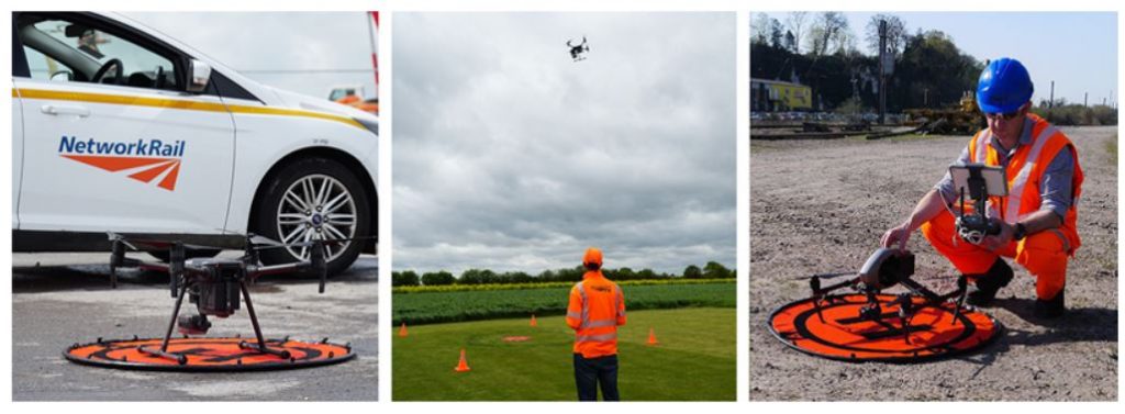
ARPAS-UK Member, Dronecloud today announced that it has been appointed by Network Rail to deliver Drone Management Software across its drone fleet. The deal covers the development and license of the software over the next five years. Network Rail will use the software to manage the deployment of multiple drone projects, monitoring and surveying rail infrastructure whilst managing in-house and contracted drone pilot’s activities. The software will support the safe, compliant and efficient running of concurrent projects and create an audit trail of completed work.

Enterprise deployments of drones are now being used across industries to survey and monitor sites which would previously be expensive, complex, or unsafe to monitor in person. The use of drones, however, comes with its own complexities, amplified when scaled. Current and future proposed legislation provides rules and guidelines on the proper planning, operation and reporting of drone use. Similarly, the logistics of managing hundreds of drone projects quickly becomes difficult, ensuring the drones are fit to fly, that the operator is suitably qualified and that the task is properly specified.

Dronecloud is a provider of Drone Management Software. Its technology is designed to streamline the administration of drone operations safely, at scale. Whilst it works for individual drone pilots wanting to create and store audit trails, for enterprise clients it also offers to significantly cut operating costs by combing business and technical tools. Ultimately, it aims to support its clients to be able to safely operate drones beyond visual
line of sight.

Speaking of the agreement, Dronecloud’s CEO Jan Domaradzki said: “Network Rail is the perfect partner for us. We have a shared vision of the efficiencies that well managed drone operations can give to infrastructure projects. Network Rail has demonstrated that it is forward-thinking, its team understands the challenges and complexities of enterprise scale drone operations, so we are well aligned on where we can support them now, and in the future.

In many industries drone operations have evolved organically, with more and more tasks being completed by drones as the benefits are better understood. As operations become more complex, we’re experiencing a high level of enquiries from companies that are keen to ensure that they are both compliant, efficient and, above all, safe in how they operate. With
dozens, if not hundreds of drone projects running, the traditional mosaic of multiple datapoints, spreadsheets, emails, is just not a sustainable way of managing operations. It’s a busy an exciting time to be rolling out our software to more clients.”

Rikke Carmichael, Head of Air Operations at Network Rail said: “With the number of drone flights at the level it is and only going to climb higher in the future, we needed a flight management system to manage the load to ensure we are as efficient and safe as possible. It will show drone pilots if another drone is operating nearby, as well as alert the pilot to other potential ground or air hazards in the area of the flight.”

About Dronecloud
Dronecloud is a London based, Software as a Service (SaaS) technology company. Dronecloud’s platform simplifies management of workflow for commercial drone operators through a cloud-based SaaS platform. The platform is designed to be the most sophisticated of its type, bringing together the highest quality tools in the drone industry with custom
integrations offering users simple management of the complete job timeline from quotation to completion and beyond.

Developed by drone operators for drone operators, Dronecloud provides one central ecosystem for organisations using drones to manage complex operations. The platform launched in June 2019 following several years of development and testing.

More information
For press: press@dronecloud.io
For customers and partners: hello@dronecloud.io

2 February 2021