

The retail and logistics sectors are on the cusp of a revolutionary change, driven by the advent of drone technology. A recent report by PwC’s Drone Powered Solutions – Global Center of Excellence in Drone and Geospatial Technologies – has shed light on the transformative potential of drone deliveries in these industries.
The report, “Drone Deliveries: Taking Retail and Logistics to New Heights,” provides a comprehensive analysis of the market potential for drone deliveries, particularly in the business-to-consumer (B2C) segment. It suggests that by integrating drone deliveries, retailers and logistics companies can significantly enhance customer experience, tap into new customer segments, and streamline their operations.
One of the key insights from the report is the projection of a steep increase in B2C drone deliveries. From an estimated 14,000 daily deliveries in 2024, the number is expected to skyrocket to 808 million within a decade. This growth trajectory is not just about quantity; it’s also about cost-efficiency. The current cost per delivery ranges between $6 and $25, but this is anticipated to drop by more than 70% over the next ten years. Such a reduction would not only make drone deliveries competitive with traditional last-mile delivery costs but could potentially surpass them, marking an inflection point for the industry.
The economic implications are vast. The value of goods delivered to consumers by drones is projected to grow by 74% annually, from $251 million in 2024 to a staggering $65,177 million in 2034. This growth is not uniform across all geographies, though. Urban centers, with their unique challenges such as safety risks, fewer suitable landing zones, and complex infrastructure needs, are expected to see a slower adoption rate. In contrast, suburban, rural, and remote areas, which often lack efficient delivery options, are poised to benefit sooner from drone deliveries.
The report also touches on the challenges that need to be addressed to realize the full potential of drone deliveries. These include creating the necessary infrastructure, particularly in urban areas, and navigating the regulatory landscape to ensure safety and privacy concerns are met.
For investors, the burgeoning drone delivery market presents an exciting opportunity. The sector’s growth is fueled by technological advancements and the increasing demand for faster, more efficient delivery services. As the report indicates, the next decade could see drone deliveries become a common sight, transforming the way we think about retail and logistics.
The PwC report is a call to action for businesses to consider how they can leverage drone technology to stay ahead of the curve. It’s not just about keeping up with the competition; it’s about redefining the industry and setting new standards for customer satisfaction and operational efficiency.
The future is looking up, and it seems the sky is not the limit after all – at least, not for the innovative world of drone deliveries.
For further industry reports, click here.
13 November 2024

ARPAS-UK has today published its first Drone in Action Report. The purpose of this guide is to provide examples which demonstrate the range of benefits and financial savings that can be achieved by the safe adoption of Drones.
Graham Brown, Chair of ARPAS-UK says, “When applied, drones are faster, cheaper, safer and greener than other solutions for the same job. We want businesses, as well as the general public, to understand the immense benefit of drones and understand that there will be positive adoption over the coming years.”
In the dynamic landscape of technological advancement, the safe adoption of drone technology stands as a testament to innovation, human ingenuity and its capacity to redefine and improve industrial operations. This report examines a collection of use cases across a spectrum of sectors, each showcasing the transformative impact of drones. From asset and building inspection to the precision agriculture fields to the complex infrastructures of oil and gas platforms, we explore how uncrewed aerial vehicles or drones are not just enhancing operational efficiency but also creating the path towards a safer, more sustainable future.
Author: Mohammed Hasan
Support by: Graham Brown, Anne-Lise Scallierez, Aleksander Kowalski, Chris Daniels, Sarah Lay, David Thurston, Rupert Dent, Elena Major, Annabel Worthington, Ashna Sharma, Dylan Brooks & Prajjwal Roy
Graphics: Sam Barrett, Manna & Canva
View further Drones & Industry Reports
12 November 2024
Download of the Drone in Action Report
Author: Mohammed Hasan
Support by: Graham Brown, Anne-Lise Scallierez, Aleksander Kowalski, Chris Daniels, Sarah Lay, David Thurston, Rupert Dent, Elena Major, Annabel Worthington, Ashna Sharma, Dylan Brooks & Prajjwal Roy
Graphics: Sam Barrett, Manna & Canva

This blog is written for organisations and professionals navigating the evolving regulatory landscape for drones in critical sectors, offering insights into how new UK, EU, and US standards are shaping UAV cyber security requirements.
The rapid expansion of drone technology is reshaping whole industries such as defence, critical infrastructure, and emergency services;, however, this expansion demands an equally fast response in regulatory oversight, especially concerning cybersecurity and supply chain integrity. In the UK and Europe, regulatory developments are intensifying as lawmakers respond to the risks and potential vulnerabilities drones introduce, there’s also the additional influences of established US frameworks, such as the Blue UAS and Green UAS programs that are worth considering and will be explored below. These programs in the U.S. prevent certain foreign technologies, including semiconductors from restricted nation-states, from being used in drones within national security, defence, and critical infrastructure.
European NIS2 Directive
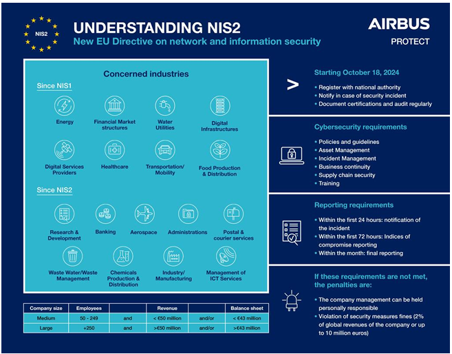
The NIS2 Directive aims to strengthen cybersecurity across the EU, focusing on sectors of essential services, including energy, transport, and digital infrastructure (critical infrastructure). Enacted in early 2023, NIS2 mandates all EU member states to integrate these standards into national laws by October 2024.
This directive potentially imposes stringent cybersecurity standards for industries using ‘connected’ drones in critical infrastructure, including risk management protocols, vulnerability assessments, and mandatory incident reporting within 24-72 hours. NIS2, while not UAV-specific, brings drones under its scope in any industry where they serve critical functions.
The UK Cyber Security and Resilience Bill is a significant upcoming regulation expected to come into force in 2025. This bill will likely include strict cybersecurity guidelines, secure supply chain
requirements, and reporting mandates for sectors where drones are increasingly deployed such as
transport, energy, and health.. Though details are still unfolding, this bill reflects the UK’s alignment with EU cybersecurity standards and will become a pivotal law for any organisation using UAVs in critical sectors.
The EU Cyber Resilience Act passed in 2023 and anticipated to be enforceable by 2025, sets requirements for the cybersecurity of connected devices across industries. Though not UAV-focused, it covers all devices communicating within a network, including drones used in sensitive sectors. The CRA mandates secure-by-design principles, continuous patching, and risk assessments throughout a device’s lifecycle, ensuring that UAVs used in critical industries maintain a high level of cybersecurity.
The Blue UAS and Green UAS programs, led by the U.S. Defense Innovation Unit (DIU) and the Association for Uncrewed Vehicle Systems International (AUVSI), set high security and sourcing standards for drones in U.S. defence and critical infrastructure. Specifically, they ensure that drones meet rigorous cybersecurity and supply chain requirements, preventing drones containing semiconductors and components from restricted nation-states from entering US markets for national security uses. The focus on sourcing transparency and third-party testing reduces the risk of foreign influence and data compromise.
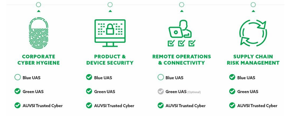
Driven by similar national security and geopolitical concerns, the UK and Europe are gradually adopting comparable standards, recognising the importance of secure sourcing and strong threat mitigation as drones take on increasingly critical roles in high-stakes sectors.
The UK and EU are intensifying regulatory efforts to secure UAVs, driven by geopolitical tensions, technological advances, and the growing role of drones in critical sectors. Key trends include:
To stay compliant and competitive, organisations leveraging drones in critical sectors should take proactive steps to prepare for incoming regulatory requirements, these include:
The demand for secure, resilient drone operations will only increase as regulations continue to evolve, positioning UAVs as crucial assets that must adhere to the highest security standards. As the UK and EU approach US-level security measures for drones, the regulatory environment is becoming more stringent, driven by cybersecurity concerns and global political shifts. With frameworks like the NIS2 Directive and Cyber Resilience Act coming into enforcement within the next year or so, UAV operators across critical sectors should look to prioritise cybersecurity, secure sourcing, and compliance now to stay ahead and maintain seamless business operations.
Qomodo is an ARPAS-UK Member.
Email: [email protected]
Click here for more ARPAS-UK Member Success Stories & Blogs.
11 November 2024

The British Business Bank announces an £850,000 investment into Drone Evolution from the £130m Investment Fund for Wales (IFW). This is the latest in a series of deal announcements from the Foresight Group (Foresight) who manage the £50m Equity Finance element of the IFW.
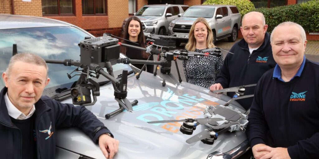
This most recent investment has been made into Caerphilly based drone development specialists and service providers Drone Evolution. It is a scaling commercial drone services company which is at the forefront of the evolution of how businesses and organisations use drones to increase levels of public safety.
When Storm Dennis tore through the UK in February 2020 and a month’s worth of rain fell within 48 hours, the team behind Caerphilly-based Drone Evolution was called upon to guide Local Authorities across south Wales’ flooded communities on how best to manage the flood’s impact on the region’s coal tips. They have been consulting with Local Authorities across the area ever since.
Drones, or Unmanned Aerial Vehicles (UAVs) are used to supply aid and food, water and medicine to areas affected by disasters, but crucially, during the aftermath of Storm Dennis’ devastation, Drone Evolution, which launched in November 2018, was able to inspect infrastructure damage, problem areas and terrain conditions, to assist in the clean-up operation and to provide mapping and data collection.
The nine-strong team, co-founded by business partners Clayton Earney, Toby Townrow and John Young, pilot drones and provide UK-wide consultancy services for both corporate and independent clients.
Toby Townrow, Business Development Director at Drone Evolution, said: “Much of our work is inspection and detection, as well as remedial work. We offer early analysis to prevent potential damage. Our drones are used to complete building, telecoms and typography land surveys, thermography and traffic monitoring. We have worked extensively on coal tip mapping and monitoring year on year for any shift or danger.
“We continue to work closely with local authorities to help reduce overhead costs. Our drones identify blocked drains or missing tiles on schools, to prevent leaks and damage. Flying a drone is a quicker process than having to use scaffolding or cherry pickers, which increases public and employee safety, with working at height still Britain’s biggest workplace killer.
“It was clear from our very first conversations with Foresight that we were compatible for Investment Fund for Wales support in unlocking the business’ true potential.”
Drone Evolution’s product provision continues to grow and the company has patented a tethered quadcopter design drone, which can fly for extended periods, providing many more ways for use in a commercial setting than current free-flying drones. The drone is mobile, easily portable and benefits from being able to lift payloads of up to 5kg, whereas usual capacity with similar UAVs is usually between 2kg – 4kg, if tethered.
As they are powered by a cable, these drones benefit security operations in a temporary space including sports events or music concerts.
Some of Drone Evolution’s key clients including multi national property management company CBRE facilities management company Mitie, Caerphilly Borough Council, as well as delivering in-depth land surveys for EDF Energy’s windfarm projects.
This support from Investment Fund for Wales will enable Drone Evolution to further develop their product offering and the team will also be investing in marketing. It comes almost a year since the Investment Fund for Wales was launched in late November 2023 by the government-backed British Business Bank to boost the supply of early-stage finance to small and medium-sized businesses across Wales.
Mark Sterritt, Director, Nations and Regions Investment Funds at the British Business Bank, said: “The Investment Fund for Wales was established to provide the financial backing that innovative and ambitious companies like Drone Evolution so often need and we are particularly pleased to support their expansion plans as they continue to scale.
“The Drone Evolution team is highly experienced, driven and passionate about this specialist, emerging sector, and they have already developed an impressive roster of clients. I’m looking forward to hearing more about what they do next following this significant investment.”
Ruby Godrich, Investment Manager in the Private Equity team at Foresight, said:
“Drone Evolution is an ambitious, growing business with a passionate management team. Over the last few years, the team has grown a successful drone services division whilst also developing a range of products. Foresight’s investment via the Investment Fund for Wales will help the company to further scale and in turn have a positive impact on the local economy through the creation of skilled jobs. We are delighted to be supporting Drone Evolution and look forward to partnering with the team on their exciting growth journey.”
Drone Evolution is an ARPAS-UK Member.
Email: [email protected]
Click here for more ARPAS-UK Member Success Stories & Blogs.
11 November 2024

The cladding risk of London tower blocks with ACM and HPL cladding: A National Audit Office Report and the Role of Drone Technology in Cladding Replacement.
In recent years, the safety of buildings clad with Aluminium Composite Material (ACM) and High-Pressure Laminate (HPL) has come under scrutiny following the tragic Grenfell Tower fire in 2017.
The National Audit Office (NAO) in the UK has identified in their report “Dangerous cladding: the government’s remediation portfolio“ several significant risks associated with these materials, highlighting both safety concerns and the challenges of replacing or retrofitting cladding on thousands of buildings, particularly in London.
Ministry of Housing, Communities & Local Government (MHCLG) is the main government department responsible for building safety.
The NAO report forecasts that remedial repairs could take up to the year 2037, over 20 years since the Grenfell tragedy.
So how can drones help to speed up remedial actions?
Risks Identified by the National Audit Office
The NAO report outlines key risks that arise from the widespread use of ACM and HPL cladding in the UK. These materials, particularly when combined with flammable insulation, pose serious fire risks. ACM panels with polyethylene cores, in particular, were identified as highly combustible, contributing to the rapid spread of the Grenfell fire.
As of the latest assessments, there are still thousands of buildings across the country that have not completed cladding replacement, with London being a major hotspot due to its dense population and large number of high-rise residential buildings.
The report also underscores the challenge of financing cladding remediation, with many building owners and leaseholders struggling to cover the high costs of replacement, which can run into the millions of pounds for a single structure.
The NAO stresses the urgency of accelerating the process, noting that while government funding has been allocated to assist with cladding replacement, the complexities of managing contracts, ensuring compliance with safety standards, and coordinating between multiple stakeholders have led to delays.
How Drone Technology Can Help
Drone technology has emerged as a promising tool to help speed up the process of inspecting and replacing dangerous cladding. Drones, equipped with high-definition cameras, geo spatial accuracy, thermal imaging, and other sensors, offer several advantages over traditional inspection methods.
1. Faster and Safer Inspections
Drones can quickly assess the visual condition of cladding on high-rise buildings without the need for scaffolding or rope access, reducing both the time and cost of inspections. This can drastically speed up the process of identifying which buildings require urgent remediation. Furthermore, drone inspections are safer for workers, minimising the risks associated with working at height.
2. Accurate Data Collection
Drones equipped with advanced sensors and imaging technology can capture high-resolution images, allowing for precise assessment of cladding conditions. By using drones, building managers can get a comprehensive view of the building’s exterior, identifying cracks, loose panels, and other hazards that might not be visible from the ground.
3. Cost Reduction
Traditional cladding inspections and assessments often require scaffolding, manual labor, and time-consuming processes that can be expensive. Drones, on the other hand, can reduce labor costs, eliminate the need for scaffolding, and decrease the time it takes to gather data. This, in turn, can lower overall cladding replacement costs, making the remediation process more financially feasible for building owners.
4. Efficient Remediation Planning
Drones not only assist in inspections but also provide valuable data for creating accurate digital models of buildings. This data can be used for quantity surveying and procurement cost planning for cladding replacements and determining the most cost-effective approach.
By using drones to gather precise information, contractors can plan for the most efficient material usage and construction schedules, potentially lowering the overall cost of replacing cladding in the long run.
5. Ongoing Monitoring
Once cladding has been replaced, drones can be used for routine, low-cost inspections to monitor the condition of the new materials over time. This proactive approach helps to identify potential issues early, reducing the likelihood of costly repairs or safety breaches down the line.
Conclusion
The National Audit Office’s report highlights critical risks associated with the continued use of ACM and HPL cladding on buildings in the UK, particularly in high-density urban areas like London.
As the need for cladding replacement accelerates, drone technology offers a powerful solution to address the challenges of inspection and remediation. By providing faster, safer, and more cost-effective assessments, drones can play a pivotal role in ensuring that buildings are brought up to code quickly and efficiently.
Ultimately contributing to the safety and well-being of residents across the UK.
S4G Drone Services is an ARPAS-UK Member.
Email: [email protected]

Disclaimer: All jobs posted here are from LinkedIn and other job sites including member and non-member organizations. Drone Related Jobs.

Volatus Aerospace is looking to recruit:

NPAS are looking to recruit: XP299 Futures Development Manager.

Bristow is looking to recruit a UAS SAR Operator.

Tekever are looking to recruit a Regulations Manager – Defence.

Skeye are looking to recruit a UAV Pilot.

Disclaimer: All jobs posted here are from LinkedIn and other job sites including member and non-member organizations. Drone Related Jobs.

Airpelago are looking to recruit the following:
Operations Manager, Safety Manager, Project Managers &
Support Staff

Luffy AI are looking to recruit a Control Engineer.

Sensat are looking to recruit a Marketing Manager.

Sonomatic RAIS is recruiting a Remote Pilot.

Skyports Infrastructure is looking to recruit a Test & Development Remote Pilot.