SAM IS ....
Project BLUEPRINT trials lay groundwork for open-architecture UK UTM system

Philip Hicks, partner at Campaign Catapult and Principal Consultant and Founder of Pravo Consulting reports on the latest milestones achieved by industry drone and sensor experts and academics in the pursuit of mixed use air space and safe operations beyond visual line of sight (BVLOS).

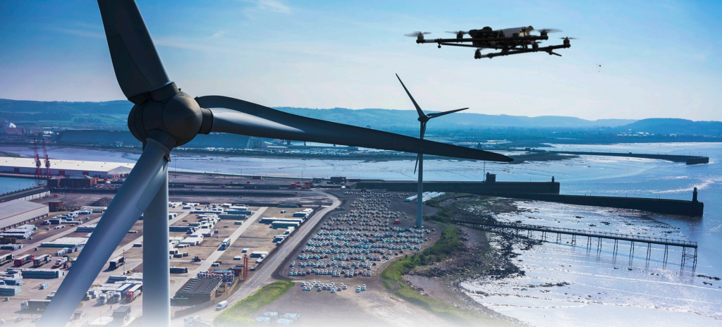
Beyond visual line of sight (BVLOS) operations have taken a step forward in the UK with the culmination of the Project BLUEPRINT showcase presented at Cranfield University’s Digital Aviation Research and Technology Centre (DARTeC) on 25 June. This initiative, under the Innovate UK Future Flight Challenge, aims to develop open-source solutions for establishing drone zones in local areas, ensuring safe and efficient operations.

Project BLUEPRINT, a two-year initiative, has been pivotal in advancing BVLOS drone operations in the UK. The project team successfully developed and integrated minimum viable products (MVPs), laying the groundwork for BVLOS solutions. A comprehensive sensor network was deployed, enhancing situational awareness and safety. Initial testing validated the system’s functionality and performance, securing approval from the relevant authorities and demonstrating compliance with aviation standards.

“Project BLUEPRINT was developed to show how ground-based surveillance networks and an open-architecture approach to UTM can enable BVLOS operations at scale,” said James Dunthorne, Strategic Lead for Project BLUEPRINT. “Our team has developed the necessary systems, integrated them, tested them, safety assessed them, and operated them in a live environment, allowing us to pull off a demonstration at this event that will hopefully give industry, government and regulators a clear vision for how the future of drone integration will come together. We’d like to thank everyone who has put in an extraordinary amount of effort to make this event so successful,”

The presentation on July 25 included live flight demonstrations in four parts covering flight plan and amendments with ‘intruder entering a transponder mandatory zone (TMZ) without permission’. Scenarios included a range of aircraft including VTOL BVLOS UAS (real take off from Cranfield Airport), Fixed Wing BVLOS UAS (simulated) and VTOL VLOS UAS (simulated)

Previous BVLOS projects have primarily operated in temporary danger areas (TDA’s) which are temporary and isolated from other airspace users, limiting scalability. These operations have focused on technology demonstrations and trials without establishing a sustainable business model.

With the blueprint for BVLOS in large part developed, the project team is now focused on the next phase: Detect and Avoid (DAA) testing.

The DAA testing phase is critical for BVLOS operations, encompassing validation of sensor coverage using ADS-B equipped unmanned aircraft systems (UAS), simulation scenarios for pilot decision-making, rigorous command performance validation, feedback loop simulations, and comprehensive system integrity testing. This phase aims to ensure the overall system’s reliability and calculate risk ratios accurately.

Next steps include working with Cranfield Airport and CAA to obtain TRA approval (by September 2024) and completion of assurance work in line with CAA’s DAA policy concept. Engaging with the general aviation industry, ARPAS-UK and CAA, the project aligns BVLOS operations with existing aviation practices. Inevitably, policymakers and regulators need to key into trials such as BLUEPRINT, and this will include alignment with the CAA’s Airspace policy concept for BVLOS flying, (dubbed as a roadmap for the development and modernisation of UK airspace until 2040).

Graham Brown, Chair of ARPAS-UK summarised: “The path to fully integrated airspace is complex with many moving parts. This project is excellent progress towards that goal.”

Project milestones and partners

The key milestones to the project are:

  •       MVPs Built and Integrated: The project team successfully developed and seamlessly integrated minimum viable products (MVPs), forming the bedrock of the BVLOS solution.
  •      Sensor Network Installation and Modelling: A comprehensive sensor network was meticulously deployed and modelled, enhancing situational awareness and safety.
  •      Initial Testing Completed: Rigorous testing validated system functionality and performance.
  •      OSC (Operating Safety Case) Approval: The project secured approval from the relevant authorities, ensuring compliance with regulations.
  •     TRA (Temporary Reserved Airspace) Application in Process: The team is part way through the process with the CAA to enable ADS-B mandated airspace to conduct routine operations.

Project BLUEPRINT relies on the collective efforts of the following organisations:

Many of the above organisations are ARPAS-UK Members.

Philip Hicks, 30 June 2024

From Project BLUEPRINT trials lay groundwork for open-architecture UK UTM system – Unmanned airspace

SAM IS ....
Dronecloud and Frequentis collaborate to integrate drone platform with ATC systems

Dronecloud, the drone Flight Management Software provider, has selected Frequentis to join a
consortium that will collaborate on the development of open standard integrations to help
unlock Beyond Visual Line of Sight (BVLOS) Drone flights in the UK. Frequentis will support
Dronecloud and the consortium with its vast and extensive experience in deploying its
unmanned traffic management (UTM) solution – MosaiX UTM. This solution provides the air
traffic control (ATC) front-end application and the Common Information Service (CIS) cloud
platform during project execution.


The intuitive tower application, smartSIS, developed by Frequentis with the strong involvement of user
interface experts in close cooperation with air traffic controllers (ATCOs), allows airspace rules and
restrictions to be set fairly for all airspace users. The solution provides an integrated air situation picture
and supports real-time decision-making. In addition, the MosaiX UTM includes a foundation for U-space
(unmanned airspace) services and the CIS function, serving as the “single source of truth” for relevant
safety information to reach connected stakeholders.


As part of Project Rise field trials, Cranfield Airport will be trialling Dronecloud and Frequentis’
integration in parallel with ATC. Robert Abbott, Director of Aviation Operations at Cranfield University,
said: “Cranfield Airport is excited to be supporting Cranfield University and other consortium members
on Rise and further expropriation of utilisation with other drone and UTM systems. Cranfield Airport is
looking forward to trialling Dronecloud and Frequentis as part of this important research project.”
Dr Saba Al-Rubaye (Principal Investigator), Senior Lecturer in Autonomous and Connected Systems at
Cranfield University added: ”We’re delighted to be part of the Project Rise team, and welcome
Frequentis to the project. Together we are working to address the challenge of establishing reliable
data and communication systems for unmanned aerial operations and their safe operation with manned
aircraft in the same airspace.”

“The key to unlocking the full potential of drones is allowing them to fly beyond visual line of sight,” says
Guenter Graf, Frequentis Vice President Business Development. “To operate under these conditions
both manned aviation and drones must have access to a shared air situation picture. Together with
Dronecloud and other consortium members we intend to demonstrate an Unmanned Traffic Page 2 | 3
Management ecosystem, incorporating end-to-end communication and an approval process between
drone operators and air traffic control authorities.”


Dronecloud is leading the Project Rise consortium, formed as part of the Future Flight Challenge
funded by UK Research and Innovation, through the multi-billion-pound Industrial Strategy Challenge
Fund. The consortium is composed of key industry partners, including Frequentis, Sky-Drones,
Cranfield University and Skyports. The project is part of an overall effort across the drone industry to
integrate disparate systems at scale, to achieve safer, more reliable and auditable drone flights, even
beyond the line of sight.

Frequentis already has extensive experience with the integration of air traffic management (ATM) and
UTM, and is currently implementing the first UTM system in the Nordic region, for Norway’s Avinor Air
Navigation Services. This is the first UTM system to receive Civil Aviation Authority (CAA) approval for
implementation. The company is also the largest industry partner in the Austrian AIRLabs project,
aiming to build and operate test sites for Unmanned Aerial Systems (UAS), covering all development
stages from simulation to actual state-of-the-art BVLOS drone missions.


“Welcoming Frequentis to Project Rise was a natural fit. Frequentis brings a proven track record in
delivering safety critical systems for Air Traffic Control and other airspace managers. Combined with
Dronecloud and the other consortium partners, we are developing a standardised, automated digital
flight approval solution ready to unlock BVLOS flights, safely at scale. This in turn will form one of the
backbone elements of the eventual ‘System of Systems’ the industry will need to offer increasing levels
of automation and autonomy. If we get these critical building blocks right, the hype around drone-based
last-mile delivery in built up areas, and Urban Air Mobility will become reality,” Dronecloud Co-founder
and CEO, Jan Domaradzki.

SAM IS ....
Network Rail Drone Flight Approval

ARPAS-UK Member, Dronecloud recently announced it was awarded a 5-year deal to provide Flight Management Systems (FMS) for Network Rail’s growing drone operation. The deal delivers safety and efficiency for the drone operations of today while paving the way for Network Rail to embrace the opportunities offered by future drone technology such as Beyond Visual Line of Sight (BVLOS) and Autonomous flight.

Dronecloud & Network Rail worked together to extend the rapidly expanding features within the Dronecloud platform to all drone users (commercial or recreational) planning to fly over or near the Network Rail Line infrastructure.

The output of this close collaboration is a simple to use digital flight approval process built in to Dronecloud.

A REQUEST TO ALL DRONE PILOTS:
If you or your company operate drone flights that come within 50 metres of the Network Rail’s line network, they kindly ask that you submit the flight plan and for approval.

It’s a quick and easy process requiring basic flight details and risk assessment. The tools and templates to do this are built into Dronecloud with an intuitive step-by-step workflow guiding you along. Approvals are typically given with 24 hours.
https://app.dronecloud.io/


AIRSPACE APPROVALS – A CALL TO INDUSTRY STAKEHOLDERS
This is the UK’s first airspace approval platform to digitally engage infrastructures owners with drone end-users for direct approval. The system has proven hugely successful for both Network Rail and drone operators and acts as the perfect Blue Print for Infrastructure and other bodies who are looking to better manage the safety and control of airspace.

The future of drone airspace approval will be dynamic, real-time and part of a wider, more integrated Unified traffic management service. To get there, Dronecloud are requesting help and engagement of similar infrastructure owners such as airports and aerodromes etc. In fact any entity who has a growing need to improve visibility of the drone flights that are occurring in and around their assets.

We’re looking to work with different industry sectors to expand on the amazing progress Network Rail and Dronecloud have made. If you’d like to work with us and be part of this exciting journey, please get in touch with Andrew Blogg.
[email protected]

7 April 2021

SAM IS ....
Network Rail Appoints Dronecloud to supply Enterprise level Drone Management Platform


ARPAS-UK Member, Dronecloud today announced that it has been appointed by Network Rail to deliver Drone Management Software across its drone fleet. The deal covers the development and license of the software over the next five years. Network Rail will use the software to manage the deployment of multiple drone projects, monitoring and surveying rail infrastructure whilst managing in-house and contracted drone pilot’s activities. The software will support the safe, compliant and efficient running of concurrent projects and create an audit trail of completed work.

Enterprise deployments of drones are now being used across industries to survey and monitor sites which would previously be expensive, complex, or unsafe to monitor in person. The use of drones, however, comes with its own complexities, amplified when scaled. Current and future proposed legislation provides rules and guidelines on the proper planning, operation and reporting of drone use. Similarly, the logistics of managing hundreds of drone projects quickly becomes difficult, ensuring the drones are fit to fly, that the operator is suitably qualified and that the task is properly specified.

Dronecloud is a provider of Drone Management Software. Its technology is designed to streamline the administration of drone operations safely, at scale. Whilst it works for individual drone pilots wanting to create and store audit trails, for enterprise clients it also offers to significantly cut operating costs by combing business and technical tools. Ultimately, it aims to support its clients to be able to safely operate drones beyond visual
line of sight.

Speaking of the agreement, Dronecloud’s CEO Jan Domaradzki said: “Network Rail is the perfect partner for us. We have a shared vision of the efficiencies that well managed drone operations can give to infrastructure projects. Network Rail has demonstrated that it is forward-thinking, its team understands the challenges and complexities of enterprise scale drone operations, so we are well aligned on where we can support them now, and in the future.

In many industries drone operations have evolved organically, with more and more tasks being completed by drones as the benefits are better understood. As operations become more complex, we’re experiencing a high level of enquiries from companies that are keen to ensure that they are both compliant, efficient and, above all, safe in how they operate. With
dozens, if not hundreds of drone projects running, the traditional mosaic of multiple datapoints, spreadsheets, emails, is just not a sustainable way of managing operations. It’s a busy an exciting time to be rolling out our software to more clients.”

Rikke Carmichael, Head of Air Operations at Network Rail said: “With the number of drone flights at the level it is and only going to climb higher in the future, we needed a flight management system to manage the load to ensure we are as efficient and safe as possible. It will show drone pilots if another drone is operating nearby, as well as alert the pilot to other potential ground or air hazards in the area of the flight.”

About Dronecloud
Dronecloud is a London based, Software as a Service (SaaS) technology company. Dronecloud’s platform simplifies management of workflow for commercial drone operators through a cloud-based SaaS platform. The platform is designed to be the most sophisticated of its type, bringing together the highest quality tools in the drone industry with custom
integrations offering users simple management of the complete job timeline from quotation to completion and beyond.

Developed by drone operators for drone operators, Dronecloud provides one central ecosystem for organisations using drones to manage complex operations. The platform launched in June 2019 following several years of development and testing.

More information
For press: [email protected]
For customers and partners: [email protected]

2 February 2021

SAM IS ....
BT & Altitude Angel lead consortium to deliver ‘Future Flight’ Drones Project to revolutionise airspace


London, UK:
  BT took a significant leap into the commercial drones market today, as the company announced, alongside Altitude Angel, the formation of a new consortium to deliver a series of industry use cases across the UK’s first commercial drone corridor.

BT,  together with Altitude Angel and a number of UK tech start-ups, have been selected by UK Research and Innovation to deliver “Project XCelerate” – a key Future Flight Challenge project which will establish the UK’s first commercial drone corridor in open and unrestricted airspace, located south of Reading, Berkshire.

In summer 2021, the project will conduct flight trials along the 8km-long corridor to demonstrate how drones can operate safely in the same airspace as manned aviation. The consortium will demonstrate key industry use cases across healthcare, emergency services and infrastructure to illustrate how drone deliveries and inspection can bring countless benefits to businesses, the public sector and UK citizens. 

Gerry McQuade, CEO of BT’s Enterprise unit, said: “As drone numbers continue to rise, there is an urgent need to safely integrate commercial drones into global airspace alongside manned aviation. In showing how drones can deliver improved, potentially life-saving services to the public, we’re aiming to accelerate the adoption of fully automated drones in unrestricted UK airspace in a safe and responsible way.”

“From improved mobility, connectivity, healthcare and manufacturing output, to reduced road congestion and pollution, automated drone technology will transform the quality of our lives. BT’s role in the consortium is to bring world-leading drone expertise together and to provide the secure and resilient mobile network connectivity, as well as our drone detection services. The power of EE’s 4G and 5G networks will ensure commercial drones remain connected for greater situational awareness, accurate positioning and to avoid collisions – ensuring that they can be operated safely and responsibly across UK skies.”

Richard Parker, Altitude Angel, CEO and founder said: “Project XCelerate is bringing together experts and world leaders in their respective fields, something we’re very proud and excited to be a part of. Our Arrow technology is truly ground-breaking and the key enabler to the project and we’re pleased to be deploying it for maximum benefit in the UK first.”

Joining BT and Altitude Angel as part of the consortium are: drone technology experts from Dronecloud, HeroTech8 and Skyports, cyber security provider Angoka, and end user experts SkyBound Rescuer and DroneStream.

The key use cases which will be explored by the consortium include using drones to assist the emergency services, for example during road traffic collisions and search and rescue missions. Using 3D mapping techniques, drones can be used for forensics purposes to aid the police when responding to road traffic collisions and can also help to locate missing persons during search and rescue missions. Project XCelerate will prove how drone technology can be used to speed up response times for such incidents, helping the emergency services to improve the chances of survival, whilst also reducing costs.

The project will also demonstrate how automated drones can reduce the lead times for urgently needed medical deliveries, helping the healthcare and pharmaceutical sectors to improve standards of patient care. A further use case is key infrastructure inspection, where drones can be used to help assess damage or maintenance required for critical national infrastructure for the utilities, telecoms and transport sectors.

BT’s strengths in reliable, secure, high bandwidth, low-latency radio and fixed connectivity mean it is ideally placed to lead the consortium. Its EE mobile network – the biggest and fastest in the UK, and the trusted provider behind the critical Emergency Services Network (ESN) – will ensure that a safe commercial drone corridor can be established with optimal mobile coverage at altitude. BT will provide the critical communications required for BVLOS (Beyond Visual Line of Sight) environments such as GPS location and remote identification, command and control, redundant geo-awareness, and live notifications (NOTAMs) sent directly to drones in-flight.

BT will combine its experience with Altitude Angel’s leading experience in Unmanned Traffic Management (UTM) platforms, together with its operation of the Arrow Drone Zone commercial drone corridor. UTM is a key enabler to address the safe and efficient integration of unmanned vehicles into airspace. Project XCelerate will combine a network of existing and new technologies underpinned by Altitude Angel’s proven UTM platform, incorporating existing air traffic management and communications systems and augmented by new technology, such as 5G.

Project XCelerate aims to widen the use of UTM systems by providing a framework which towns, cities, organisations and networks can follow in order to ‘open up’ portions of the sky. The project consortium is powerfully placed to realise the world’s first live commercial automated BVLOS flight zone in which any compatible vehicle can connect into and fly within safely.

For further information

15th December 2020

SAM IS ....
Dronecloud leads new UKRI Consortium to deliver the integration of software systems required for BVLOS drone flights


Project Rise provides a crucial building-block for the systems needed to unite manned and unmanned aircraft safely in the same airspace.


Project will culminate in field trials of an UAS delivery operation supporting Beyond Visual Line of Sight drone flights at Cranfield University test facility
Project received grant of £500,000 from UK Research and Innovation fund as part of Future Flight Challenge.


Dronecloud, the Drone Management Software provider, has today announced it is leading a consortium to support Beyond Visual Line of Sight (BVLOS) Drone flights. The consortium has formed ‘Project Rise’, part of the Future Flight Challenge project1 funded by UK Research and Innovation, through the multi-billion-pound Industrial Strategy Challenge Fund. It is composed of key industry partners, including Sky-drones, Cranfield University and Skyports.


The project aims to integrate evolving Unmanned Traffic Management (UTM), the drone version of Air Traffic Control (ATM), with the control systems onboard drones. It will then form part of a Centralised Command and Control Solution, based on the existing Dronecloud Software as a service (SaaS) platform. The project is part of an overall effort across the drone industry to integrate disparate systems at scale, to achieve safer, more reliable and auditable drone flights, even beyond the line of sight.
Dronecloud is a provider of Drone Management Software. Its technology is designed to streamline the administration of enterprise drone operations safely. The company offers to significantly cut operating costs by combining business and technical tools. Ultimately, it supports its clients to be able to safely operate drones beyond visual line of sight.


Project Rise will develop an integrated software and hardware hub proof of concept. The complete system will include Unmanned Aircraft Systems (UAS) hardware, ground control stations, flight commissioning and planning, flight control and telemetry, deconfliction services, supplementary data feeds, airspace authorisations, flight noticeboard, Electronic ID, auditability, flight termination, accident and incident reporting, and digital flight logging. The project will culminate in field trials of an UAS delivery operation supporting BVLOS drone flights at the Cranfield University test facility. The system will work within the Open UTM
framework to identify and create open system integrations that will be transferrable to the wider drone industry.


Speaking of the project, Dronecloud Co-founder and CEO, Jan Domaradzki, said: “Moving beyond the hype to integrate drones into congested urban airspace remains a tough nut to crack, and that’s a good thing. It’s our job to create the behind the scenes systems that will ensure it can happen safety at scale, in order to win the trust of the public and regulators. It’s a great honour for the team at Dronecloud to gain the backing of the Future flight challenge to form this consortium. We’re looking forward to creating the infrastructure for the aerial highways of the future.”


In many industries, drone operations have evolved organically, with more and more tasks being completed by drones as the benefits are better understood. As operations become more complex, Dronecloud and its partners ensure that they are both compliant, efficient and, above all, safe in how they operate. With dozens, if not hundreds of drone projects running, the traditional mosaic of multiple datapoints, spreadsheets, emails, is just not a sustainable way of managing operations.”


The global Beyond Visual Line of Sight – BVLOS drone market (revenue) is currently estimated at approximately $19B, (CAGR) of nearly 6% and a projected market size of $34B by 2029 Global. Europe is estimated to account for approximately 25% of the global drone market, with a projected BVLOS market worth $8.5B.
(Source: BVLOS Drone Market BIS Research 2019)


Dronecloud is a cloud-based Software as a Service (SaaS) solution targeted at enterprise level drone operations, built for drone operators by drone operators. Its platform and evolving ecosystem integrates complex drone fleets, team-based project management, real-time air space & ground hazard data into a risk assessed and auditable workflow built for mission
critical drone ops. Dronecloud has been helping some of the biggest UK and
International drone users with operations currently supported by Civil Aviation regulation, while paving the way for Beyond Visual Line of Sight and increased autonomy & automation. The future of drone operations, Today!


https://dronecloud.io/


More information
For press: [email protected]
For customers and partners: [email protected]
Call Dave Bush for further information: +44(0)7868738159
About Project Rise:
“Unlocking the future of drone operations through integration.”
Project Rise is a UK consortium setting out to solve a global problem: how do we safely and reliably integrate unmanned aircraft into the same airspace as manned aircraft over some of the world’s busiest and densest urban conurbations? Project Rise aims to do that through creating a system can communicate between drones and manned aircraft simultaneously.


Member organisations:
Dronecloud (ADJsoft Limited) – Project Lead
Sky-Drones Technologies – Drone Hardware and Software
Sky-Drones’ Kirill Shilov (Founder & CEO): “Our main goal is to accelerate the development and adoption of unmanned aerial vehicles for enterprise by building connected hardware and software products for drone manufacturers and commercial drone service providers. We always strive to improve the safety and efficiency of drone operations and this collaboration will help to bring this to the next level.”
About Sky-Drones Technologies: https://sky-drones.com/
LinkedIn: Sky-Drones
Twitter: @skydronescom


Cranfield University – Academic research partner (Systems Integration, Target Operating Model & Legal)
Dr Saba Al-Rubaye, Senior Lecturer in Autonomous and Connected Systems at Cranfield University said: “The impact of the Covid-19 pandemic and subsequent social distancing measures has expedited the need for the fast and efficient delivery of goods – autonomous drones are an ideal solution for this. We’re delighted to be part of the Project Rise team, working to address the challenge of establishing reliable data and communication
systems for unmanned aerial operations and their safe integration with manned aircraft in the
same airspace.”
About Cranfield University: www.cranfield.ac.uk/aerospace


Skyports Ltd – Drone Delivery Service Provider (inc. Regulatory approval consultancy)
James Bircumshaw MRICS Infrastructure Manager at Skyports said:
“The integration of manned and unmanned aircraft in unsegregated airspace is key to creation of a drone delivery service that can be scaled for permanent commercial operations. We are excited to be part of Project Rise that will develop the solutions to help unlock the economic and social potential of drone technology operated beyond visual line of sight”.
About Skyports: https://skyports.net/


About UK Research and Innovation
UK Research and Innovation is a new body which works in partnership with universities, research organisations, businesses, charities, and government to create the best possible environment for research and innovation to flourish. We aim to maximise the contribution of
each of our component parts, working individually and collectively. We work with our many partners to benefit everyone through knowledge, talent and ideas. For more information visit: https://www.ukri.org

The Future Flight Challenge

Dronecloud, Cranfield University and Skyports are all ARPAS-UK Members

10th November 2020

SAM IS ....
Drone Management Platform integrates business and technical tools for the first time to halve operating costs
 ARPAS-UK Member, Dronecloud, the drone management software company, today announced the launch of its Drone Management, cloud-based software platform. The platform can halve project overheads by simplifying end-to-end workflow. It integrates all drone operations, from client communications to flight planning and it automatically creates a regulation-compliant audit trail through partnerships with global leaders in drone and air traffic data analytics.
 
The Dronecloud platform was built by a team of drone operators and designed to be the single most comprehensive tool on the market today. Smaller operators can use a free version and additional features are offered on a subscription, which starts at £30 ($35 USD) per month.
 
The platform combines both business and technical data streams, starting by moving quoting and specification of jobs from hard-to-track e-mail onto the collaborative interface. It then integrates a range of more complex tools, traditionally managed on a host of separate on and offline packages such as spreadsheets and specialist packages.
 
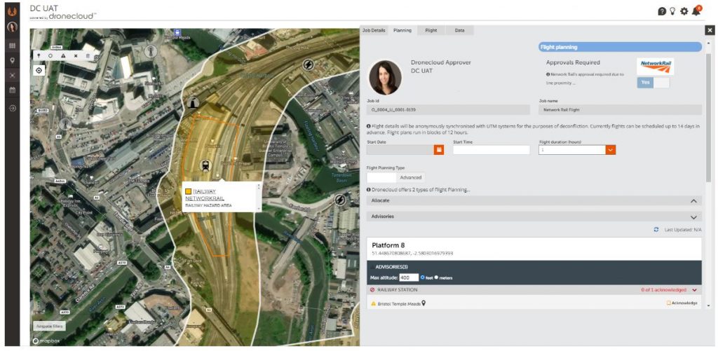
Advanced features include network management, where operators can manage subcontractors, fleet management, pilot logs as well as sharing and visualisation. Powerful project management tools give the operator’s clients complete transparency as to the status of their jobs. A single logon to accesses outcomes and audit trails. Flight planning is supplied through a partnership with Altitude Angel which provides the highest-quality, real-time geospatial data.
 
For pro and enterprise scale operations, the platform can be reskinned in custom branding, giving operators a professional looking interface through which to manage client work.  
 
Speaking of the launch of the platform, Jan Domaradzki, Dronecloud Founder said:
 
“This platform was built because, as drone operators ourselves, there simply wasn’t any software that met our needs. We needed a tool that would manage the actual business of our operations as well as compliance. 
 
Dronecloud was funded and developed from our own drone service operation and we’re proud to have built such an innovative platform without the need for outside investment.
 
Across industries we see cloud-based technologies consolidating to simplify the job of operators and yet the innovative drone industry is still using multiple disconnected, disparate tools and spending twice as long on the admin of drone operations as they need to. This platform will dramatically reduce the overhead of time and money spent in drone operations so that jobs can be quoted, planned, managed and completed, whilst meeting all regulations, quickly and easily.”
 
He continued “It was clear to us that drone management platforms have been evolving organically, adding feature upon feature to a single functionality. What we have done is different. We have approached the development of this platform with the customer wish-list front of mind, from the start. The product represents a real step-change in how companies can run their operations. We challenge operators to find a more comprehensive platform on the market today and offer a free trail to prove our confidence in the product. Our ambition doesn’t stop there. Our mission is for Dronecloud to be the most widely used platform for drone operations across all industries and ‘the go to’ for all commercial drone activities globally.”
 
Seth Zora, President of commercial drone operator Aerdia LLC in the US, who tried the platform in its Beta said “We’ve been waiting a while for something like this. Finally, a business focussed software solution for drone operations. We now run all our work through Dronecloud, it has given our team complete oversight of all our jobs and we have made great gains since moving on to the platform.”
 
The Dronecloud team will celebrate the launch of the platform at a VIP reception in London on June 26th2019. Free trials of the platform are available atwww.dronecloud.io
 
About Dronecloud
 
Dronecloud is a London based, Software as a Service (SaaS) technology company.
 
Dronecloud’s platform simplifies management of workflow for commercial drone operators through a cloud-based SaaS platform. The platform is designed to be the most sophisticated of its type, bringing together the highest quality tools in the drone industry with custom integrations offering users simple management of the complete job timeline from quotation to completion and beyond.
 
Developed by drone operators for drone operators, Dronecloud makes complex data simple to access and share. The platform launched in June 2019 after years of development and successful Beta trials. 
 
More information
For press: [email protected]
For customers and partners: [email protected]
June 26, 2019