We’re delighted that we’ll be seeing you all at this year’s event at Cranfield University, taking place on the 29th April, starting at 1100 and closing of doors at 1800.
Following the AGM in the morning, then lunch and networking, the Annual Conference will include talks and discussions across key industry themes. We’ll hear from end-users and sector leaders on market adoption, with speakers including Sellafield Ltd and Esri UK, followed by policy and regulation from the DfT and CAA, and sessions on innovation and airspace.
Interactive SLIDO will be run during the day to gather your views and questions
IMPORTANT INFORMATION
AGENDA 1100: Pre AGM & Networking 1130: AGM – Members Only 1200: Lunch 1300-1730: Annual Conference – Breaks & Networking 1800: Close of Event Read the full Agenda here
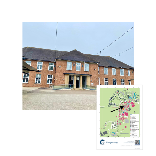
LOCATION Stafford Cripps 2 – 1st Floor (Grid 3D) Central Ave – Cranfield Wharley End – Bedford MK43 0AL Interactive Map What3Words: ///dearest.skins.prepped Train Stations: Milton Keynes Central and Bedford
PARKING & PERMITS If you are driving to the event, specific parking has been allocated to attendees: AIRC car park (grid 5D of campus map) Please download, print the Parking Permit in advance, enter your vehicle registration and display the permit inside your windscreen. (Approx 0.3 miles / 7 min walk from Stafford Cripps building)
If you have any queries, please feel free to contact [email protected]
Cranfield University Interactive Map
Google Map Location
10 April 2025
SAM IS ....
REGISTER: AGM & Annual Conference 2025 – 29 April 2025
We’re delighted this year’s ARPAS-UK AGM & Annual Conference 2025 will take place at Cranfield University – a leading institution in aerospace and autonomous systems, and a long-standing ARPAS-UK member.
It’s the ideal setting for a day of insight, discussion, and networking. We know travel isn’t always possible, so the event will be hybrid, with the option to attend in person or online via Microsoft Teams.
Following the AGM, the programme will include talks and discussions across key industry themes. We’ll hear from end-users and sector leaders on market adoption, with speakers including Sellafield Ltd and Esri UK, followed by policy and regulation from the DfT and CAA, and sessions on innovation and airspace.
Interactive SLIDO will be run during the day to gather your views and questions.
Unable to attend in person? Submit your Proxy Vote to the Chair via the Registration Form – link below
We look forward to welcoming you – in-person or online – for what promises to be an engaging and valuable event!
Need to cancel? You may transfer your place to a colleague or contact [email protected]
March 2025
SAM IS ....
Lincolnshire Prepares for Emergencies with Drones and Digital Twins
Geospatial and drone technology from ARPAS-UK member Esri UK supports more effective response to floods, power cuts and severe weather.
Lincolnshire Resilience Forum (LRF) has gone live with new geospatial and drone technology from Esri UK to help it better prepare for emergencies across the county, including flooding, loss of critical infrastructure, pandemics or severe weather. Image recognition and drone software are among new applications helping to create real-time intelligence and an improved understanding of potential catastrophes.
Covering over 2,000 square miles and a population of more than 750,000, the LRF’s objective is to save and protect human life, relieve suffering and contain emergencies, limiting their escalation by ensuring comprehensive readiness. One of 38 Local Resilience Forums in England, the multi-agency partnership consists of over 30 category 1 and 2 responders, including local authorities, government agencies, emergency services, NHS and health bodies, utilities and transport providers.
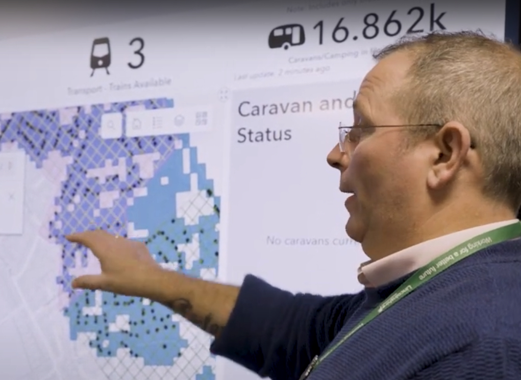
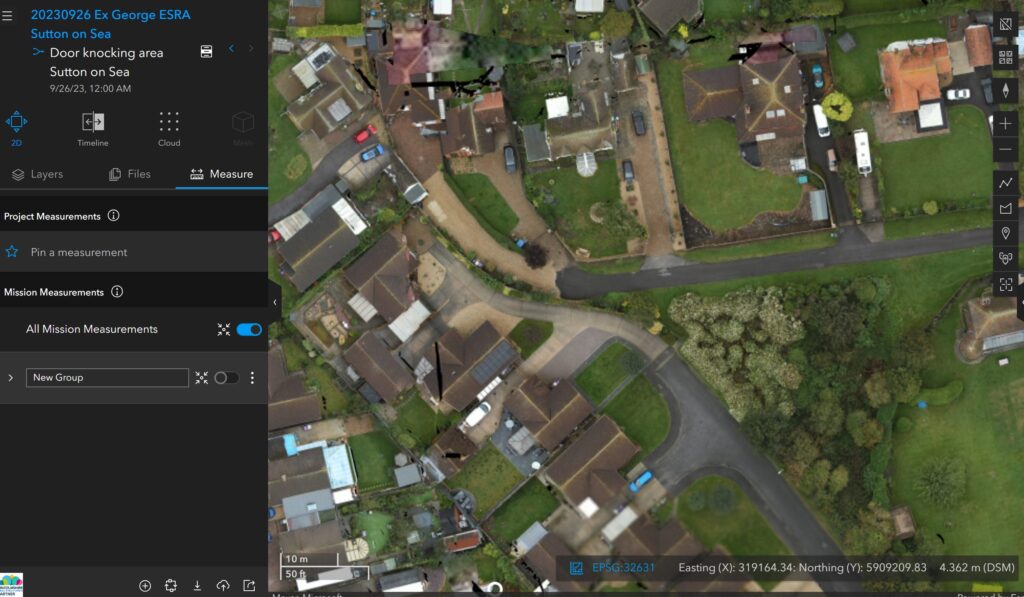
New systems are being used to identify unknown caravans using drone and satellite imagery, to gain a more accurate understanding of where residents need to be evacuated from in the event of a major flood. Preparing for tidal inundation is a top priority for the LRF due to Lincolnshire having one of the largest single landmasses in the country at risk of such an event, along with Europe’s highest density of static caravans at more than 34,000.
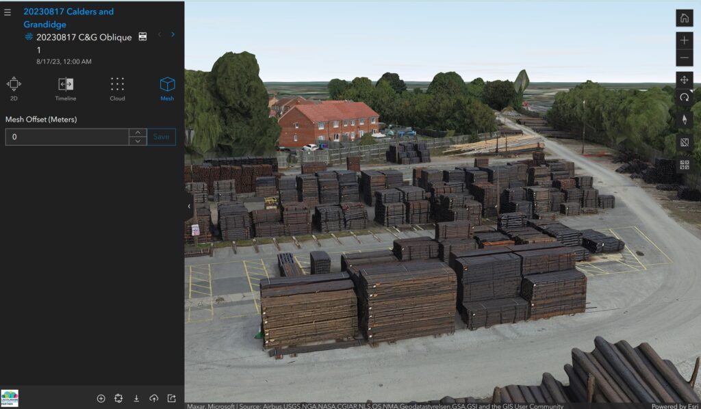
Esri drone software is making aerial data capture faster and more accurate to create 3D digital twins of potential higher risk zones, supporting better understanding of access and evacuation points in relation to homes and other properties. The new deployment means the LRF can create digital twins more quickly, particularly for Control of Major Accident Hazards (COMAH) locations, which involve dangerous substances such as gas and oil refineries.
Responding to large emergencies – particularly flooding but also major transport incidents or the loss of critical infrastructure – is a crucial role of public services. With the climate crisis comes more extreme weather events, which means community resilience is even more important.
Lincolnshire is a large county with no motorways and few dual carriageways so response and evacuation planning is critical. These new innovations are enabling emergency planners to model risks affecting the county to maximise response, improve communication and coordination and reduce, as practicably as possible, the impacts on the wider communities of the county. Creating the new caravan dataset in particular will dramatically improve intelligence.
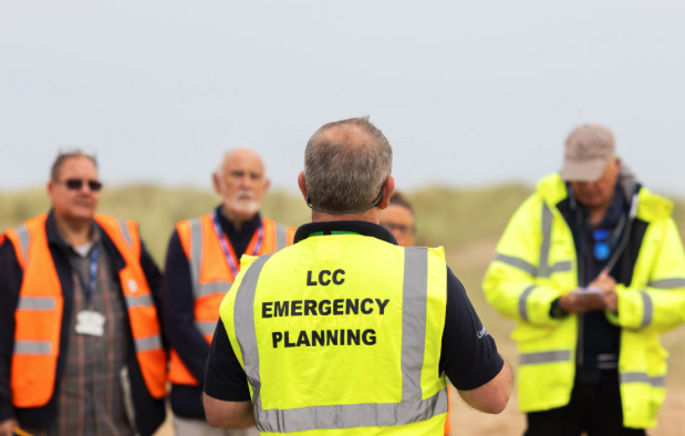
Steve Eason-Harris, Emergency Planning Officer at Lincolnshire County Council, who is the lead officer for GIS and Resilient Communities for the LRF.
Identifying static caravans is traditionally difficult due to licensing regulations, land ownership and registry data. Now with new deep learning tools available, the LRF is exploring and developing ways of employing drone and satellite imagery and GIS to identify previously unknown caravans. Tourism is the lifeblood of many coastal regions in the country but this can increase risks to coastal populations residing in caravans when holiday seasons lengthen into storm periods. In Lincolnshire, this traditionally runs from October to March.
We’re aiming to solve a huge challenge and having the latest geospatial technology means the LRF can respond more effectively. Constant innovation is critical at the LRF, the objective being to use new systems to ensure we get the right resources to the right people at the right time
continued Eason-Harris.
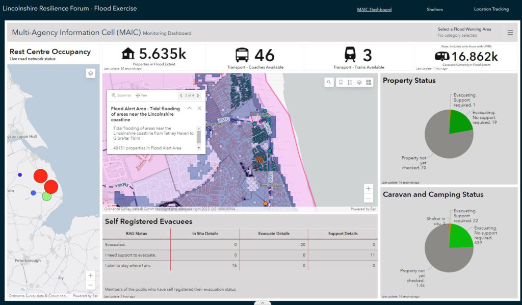
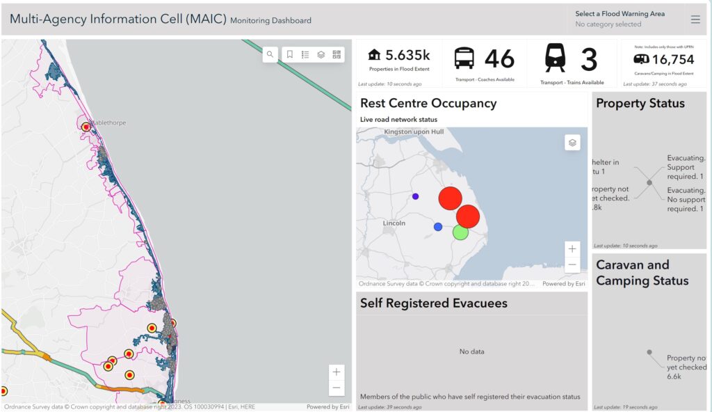
At the core of the solution lies an Esri real-time mapping dashboard, providing a common operating picture, which went live in summer 2022 and was used extensively during Storm Babet in October 2023. Available online, on mobile devices and giant touch screens in the County Emergency Centre, it integrates data from over 30 agencies to allow rapid decision making. The system provides a faster and more advanced method of showing partners what the situation is before, during and after an emergency, compared to paper maps and spreadsheets.
Other new GIS projects at LRF include developing a workforce application for deploying, tracking and communicating with volunteers in the field to support vulnerable people who need assistance the most. The system will update the control centre via a mobile app when volunteer tasks have been completed and alert the team with any requests for medical intervention or transport assistance. Data from the app will also feed directly into the mapping dashboard in the control centre.
5 December 2023
SAM IS ....
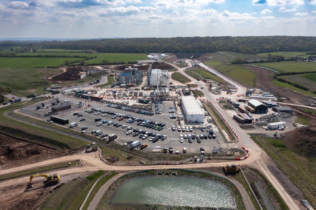
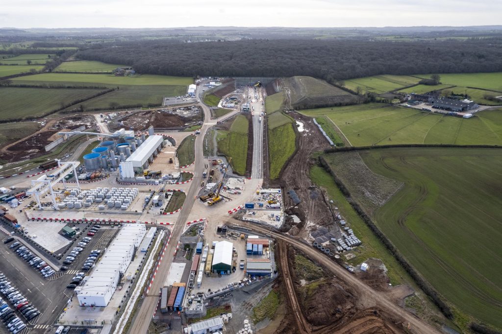
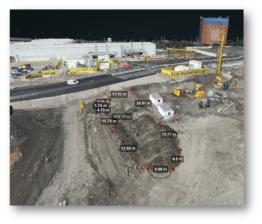
Balfour Beatty VINCI adopts drone software from Esri UK to reduce costs and enhance safety on HS2
Esri UK today announced that Balfour Beatty VINCI (BBV) has rolled out its Site Scan for ArcGIS drone flight management and image processing software, to support the use of drones on its 90km Midlands section of HS2.
Faster and more efficient drone surveys are already saving around £20,000 a year on monthly construction progress surveys on a single site, instead of using physical surveys and the subsequent updating of CAD models. BBV estimates this could save around £1.6m if the same workflow was applied across 80 sites in the first year.
Another benefit has been the removal of 800 ‘working at risk’ days and a cost saving of £30,000 per year from monitoring aggregate stockpiles, using a single drone operator to carry out 3D volumetric measurements in 20 minutes. Previously, contractors would take a full day to physically measure stockpiles and calculate transport requirements, often working in steep and difficult environments.
Drone image of Long Itchington Wood Tunnel site
Site Scan for ArcGIS is being used to carry out drone site surveys, manage aggregate stockpiles and monitor progress of construction. Various 2D and 3D outputs are being generated for sharing with multiple stakeholders, including high-definition imagery and 3D terrain models. The new software was rolled out across the BBV business to almost 400 users in autumn 2021, including 13 drone pilots.
The major civil infrastructure project spans from Long Itchington Wood tunnel in the south to the West Coast Main Line tie-in near Lichfield in the north, with a major junction into Curzon Street Station in central Birmingham. The main works civil engineering contracts will deliver earthworks, ground engineering and many structures including bridges, viaducts and tunnels along a 90km stretch of the UK’s new high speed rail line.
We needed the right software to manage an increasingly complex and varied use of drones and meet the needs of multiple teams, from logistics to site managers to engineers. New digitised workflows are rapidly replacing traditional, physical working practices and introducing new levels of efficiency, accuracy and safety. On major projects such as HS2, the ROI achieved is significant.
Dan Fawcett, Innovation Director at Balfour Beatty VINCI.
Other applications of the new software include helping to show compliance with design tolerances in built structures against BIM and CAD models, speeding-up design cycles, particularly in earthworks and excavations design and monitoring the installation of utilities. Site Scan supports RTK drones to ensure highly accurate data capture and point cloud creation. Super-user training for Site Scan is being provided by Esri UK partner Heliguy, the drone consultancy, hardware and training specialists.
Site Scan for ArcGIS is Esri’s cloud-based drone flight management and image processing software, offering flight planning, hardware management, scalable image processing and unlimited data storage, plus seamless integration with BBV’s Esri enterprise GIS system.
Notes to editors:
About Balfour Beatty VINCI
Balfour Beatty VINCI represents a powerhouse for critical infrastructure across Rail, transport and other iconic projects in the UK and beyond. Balfour Beatty VINCI’s involvement in ground-breaking Design Build Finance and Operation (DBFO) projects offers a unique end-to-end asset knowledge that is crucial in developing the best solutions to the infrastructure needs of the UK
Balfour Beatty and VINCI started working together over 30 years ago when both were members of the TransManche Link consortium which delivered the Channel Tunnel
As leading infrastructure groups, both Balfour Beatty and VINCI Construction offer opportunities for trainees, apprentices, placement students and graduates as well as sponsored degree opportunities
Esri is the global market leader in geographic information system (GIS) software, location intelligence and mapping. Esri has regional offices, international distributors, and partners providing local support in over 100 countries on six continents. Founded in 1969, Esri software is deployed in more than 350,000 organisations worldwide.
AEC organisations use Esri’s GIS to help plan, design, build and maintain smarter buildings and infrastructure. Esri UK customers include BBV, EKFB, Argent Related, Arcadis, Mott MacDonald, Skanska and Costain.
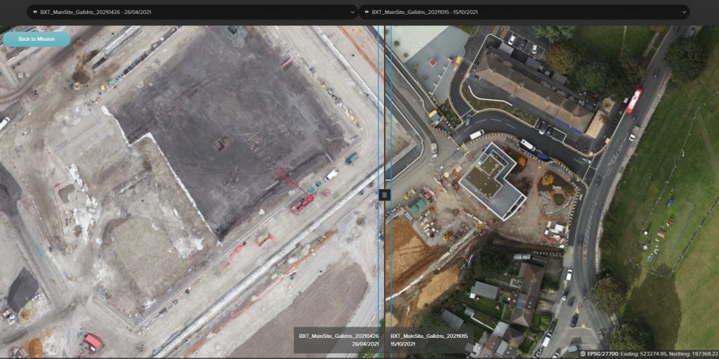
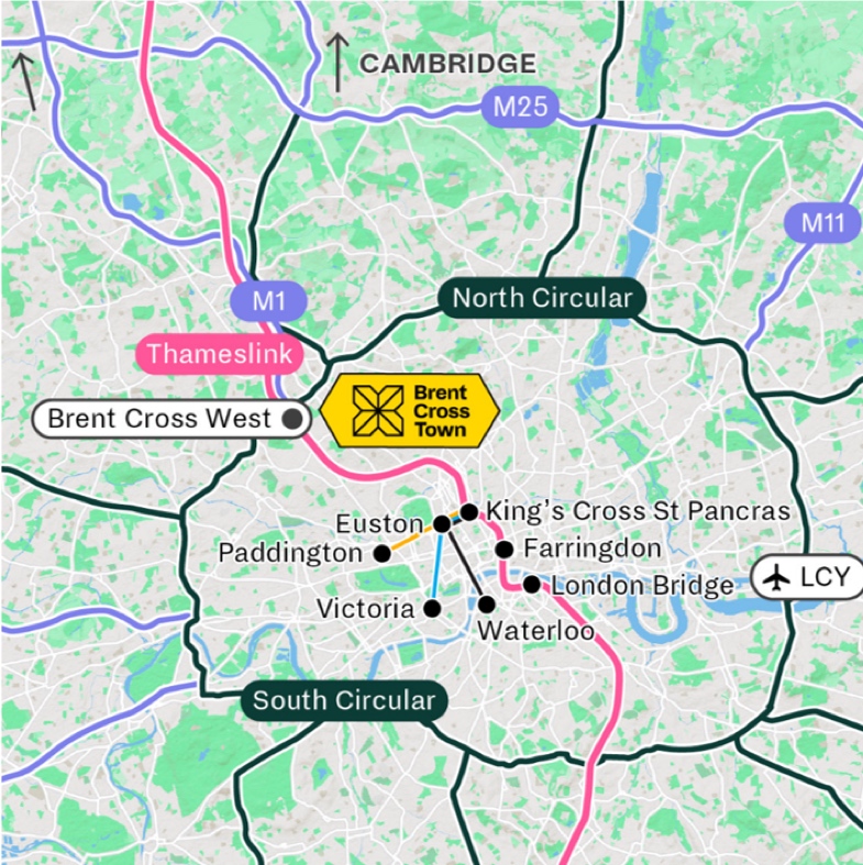
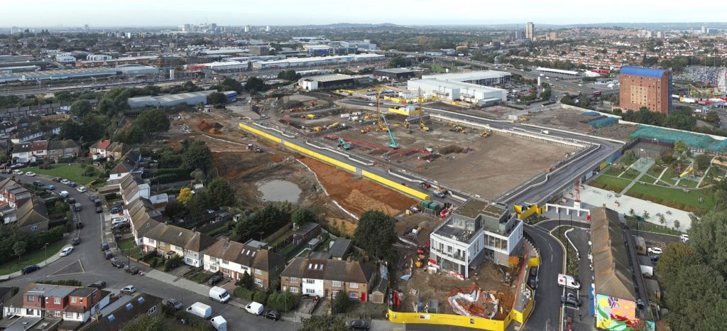
Brent Cross Town introduces new drone software to improve efficiency of surveys at £7bn North London scheme
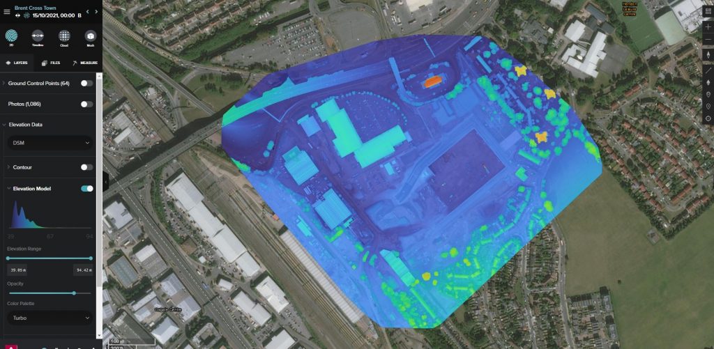
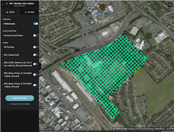
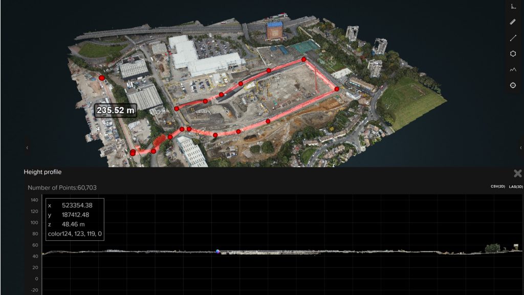
Brent Cross Town, a joint venture between Argent Related and Barnet Council, is using Site Scan drone flight management and image processing software from ARPAS-UK Member, Esri UK to improve the efficiency of groundworks surveys and how it communicates progress of the new neighbourhood. The software is being used to create 3D point clouds, textured meshes, video and 360-degree panoramas, enabling highly accurate and consistent updates to be shared amongst all stakeholders as the development progresses.
A new park town for both Barnet and London, Brent Cross Town is an ambitious new neighbourhood spanning 180 acres, incorporating 50 acres of parks and playing fields. Delivering 6,700 new homes and 3m sq ft of office space for 25,000 employees, the town will be a major new office destination. New and sustainable transport links, a high street, local amenities, services and world-class sports facilities are also part of the scheme.
Previously, drone surveys were commissioned to third parties on an ad-hoc basis, with outputs defined by the business purpose they were satisfying, such as project management, logistical planning, marketing or legal. Brent Cross Town wanted to create a more consistent and efficient method of monitoring site progress and make the overall drone programme easier to manage.
Lily Wydra, GIS, Land and Property Manager at Argent Related, explained: “Before Site Scan we had no pre-existing software specifically for planning flights or managing and processing drone imagery outputs. Now we have a consistent framework for managing all flights through our supply chain, processing images, creating high quality geospatially-enabled outputs and disseminating them to multiple stakeholders. As a cloud-based service, Site Scan also means we can work seamlessly with contractors, such as civil engineering contractor Galldris Services Ltd, who we’ve currently requested to carry out drone survey work.”
The drone team at Galldris has been regularly flying drone surveys with its fleet of DJI drones and using Esri Site Scan under Argent’s operator licence, since March 2021. Galldris has also been helping to maintain part of the network of GCPs (Ground Control Points) to aid in the auto-georeferencing of drone imagery. The team now processes monthly drone outputs to support internal operations and delivers them to Argent who utilise and disseminate them through a collection of ArcGIS Online maps and apps.
Outputs include 3D point clouds which have been helping construction managers, technical teams and contractors understand how changes in site topography will impact the site and for performing volumetric calculations, on how much earth needs to be excavated and removed. While video, static images and 360-degree panoramas have been used to provide project teams, investors and the public with engaging visual updates on construction progress and by legal teams when working on leases with potential tenants.
“Site Scan has enabled us to create a formalised and repeatable approach for generating digital drone outputs, irrespective of the survey provider, which is also proving to be more cost effective than commissioning one-off surveys,” commented Wydra. “Drone usage is increasing so having a scalable framework to manage flights and streamline the integration of data captured into GIS, BIM and CAD workflows is proving invaluable. Ultimately, better drone outputs support a better data-driven decision-making process.”
Site Scan connects seamlessly with Argent Related’s enterprise GIS, Esri ArcGIS and is already enriching geospatial datasets. Drone data can be quickly published into ArcGIS Online to enhance pre-existing online maps, including those on-site or shared with Barnet Council, who has started to publish some data layers in its Masterplan. The regular drone surveys also proved invaluable for monitoring progress remotely during COVID-19 lockdowns, when site access was limited.
Brent Cross Town is the first Argent Related project where Site Scan has been deployed but the developer business is planning to use it at other major developments, including King’s Cross and Tottenham Hale, as the demand for drone data increases.
“Deploying Site Scan at Brent Cross Town has streamlined how we carry out surveys, visualise large-scale developments and communicate site progress,” concluded Wydra. “Engineering is a precise school of activity and drones are a relatively new part of the workflow but now they are working alongside tried and tested engineering practices and surveying activities. Site Scan is helping to build a more coordinated and efficient way of managing our drone programmes and will soon move to other developments as we scale it across the business.”
Notes to editors:
About Brent Cross Town
Brent Cross Town is the neighbourhood at the heart of the Brent Cross Cricklewood regeneration programme. It is a joint venture between Argent Related and Barnet Council to develop a large-scale mixed-use development including new homes, retail and office space, as well as improved schools and greenspaces in the area. Early work started on site in early 2020 and construction is also underway on the new Brent Cross West station which will be completed by the end of 2022. Building on the strengths of this diverse part of the city, Brent Cross Town will draw inspiration from the best of London’s long-established neighbourhoods with all their complexity and character.
At its heart will be a focus on sport, play, health and well-being. The new neighbourhood will provide 6,700 homes, state-of-the-art workspace for over 25,000 people, and pedestrian friendly streets and squares with local shops and restaurants that will complement the offer at Brent Cross Shopping Centre. The community will be supported by first-class public transport infrastructure, a new and improved network of walking and cycle routes and a series of new parks and other amenities.
Argent Related brings together an extraordinary blend of complementary skills, access to global capital and unrivalled technical and delivery experience. Argent, the respected developer with a track record in creating exemplar new pieces of UK cities, including King’s Cross, joined forces in March 2015 with Related, the most prominent privately-owned real estate firm in the United States responsible for Hudson Yards. The company has an £8bn+ development pipeline in London which includes the delivery of two major regeneration schemes featuring over 7,900 homes, over 3 million sq ft of office space, 50 acres of parks and playing fields, as well as retail, leisure, student accommodation and schools, both highly accessible from new and improved public transport connections. It is currently working in a joint venture with Barnet Council on London’s 180-acre Brent Cross Town development, with the London Borough of Haringey for the Tottenham Hale redevelopment and is progressing other opportunities in London including a build-to-rent development in King’s Cross.
Esri is the global market leader in geographic information system (GIS) software, location intelligence and mapping. Esri has regional offices, international distributors, and partners providing local support in over 100 countries on six continents. Founded in 1969, Esri software is deployed in more than 350,000 organisations worldwide.
AEC organisations use Esri’s GIS to help plan, design, build and maintain smarter buildings and infrastructure. Esri UK customers include Argent Related, Arcadis, Mott MacDonald, Costain and Skanska.