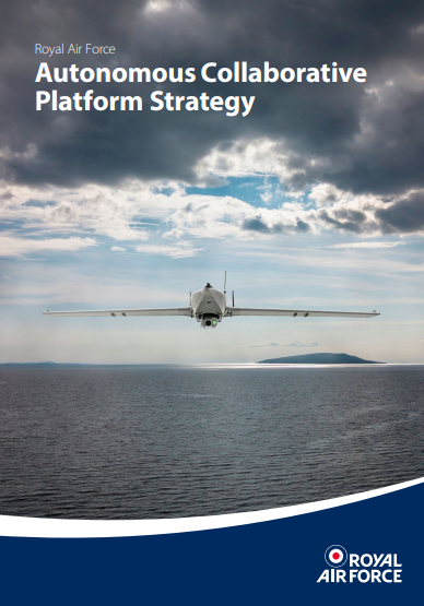
Royal Air Force Autonomous Collaborative Platform Strategy
The Royal Air Force’s (RAF’s) intent for use of Autonomous Collaborative Platforms (ACP) in the Air domain.
The Defence Drone Strategy provides the core reference baseline for the RAF ACP Portfolio ensuring coherence for the introduction of new developments in capability, supported by lessons learnt in our recent past and in current conflicts.
Advances in human-machine teaming, AI and other technologies mean that the world of uncrewed systems is rapidly advancing towards the use of autonomy. The war in Ukraine has also highlighted the rapid evolution of weapon systems and tactics. The ACP strategy sets out how the RAF intends to take advantage of this technology, working closely with the Royal Navy, British Army, across MoD, with industry, and our trusted partners and allies. This collaborative endeavour will pursue the best solutions for UK Defence, supported by UK industry, to find options with the correct cost-benefit analysis to augment our forces.
Using emerging technologies, ACP will undertake critical roles that complement and enhance the operational effects achieved by our current and future crewed aircraft, acting as a force multiplier. Implementation of this strategy will reduce risks to personnel and provide us with the opportunity and means to learn, develop and fight faster than our adversaries, whilst maintaining a keen eye on the legal and ethical considerations.
“As we look to the future, it is clear that Autonomous Collaborative Platforms will play an important part in enhancing the mass, lethality and survivability of our combat air forces. Building on the Defence Drone Strategy and in close collaboration with the Royal Navy and Army, the RAF will focus on low-cost Autonomous Collaborative Platforms to augment the operations of our existing crewed combat air platforms. We expect to field an operational capability within the next year.”
Air Chief Marshal Sir Rich Knighton Chief or the Air Staff
The strategy sets out what military capabilities and structural changes are required within the RAF to support this growth area, alongside the development of UK-based industry. Although uncrewed platforms are now commonplace, the strategy also highlights the key issues surrounding the law and autonomy as this technology matures.
27 March 2024
SAM IS ....
Drones and Low Flying Military Aircraft
Whether you are flying your drone for fun or profit, the need to fly safely and legally is often discussed. Height limits and airspace restrictions are set out in the the CAA website for all to follow and doing so will help to avoid conflict with manned aircraft and the risks that this poses. Generally speaking, civilian manned aircraft will operate over the 400ft ceiling applied to UAV flights and so you would think that observance of these limits would be sufficient to keep the airspace safe for all.
However, when carrying out essential training for operations, military aircraft have a need to fly beneath this 400ft limit, and sometimes as low as the ground in the case of helicopters taking off and landing. Collision with drones at these low heights could have disastrous consequences. These low flight exercises can take place any time of day or night, in any weather and in any location so it is something that all pilots need to be aware of, not just if you’re near an airfield or in a known low flying zone.
Ask – Look – Listen
The RAF Safety Centre have suggested several considerations that drone pilots can use to help reduce the risk of collision.
Ask
In addition to always flying in accordance with the drone code, pilots can call the freephone number below (between 0700-2000 Mon – Thu & 0700-1500 Fri). They can also be emailed.
As far in advance as possible, you can give them the date and time of your flight, the maximum height you will be flying to and the location. Your flight details will be provided to crews of low flying aircraft and they will inform you of any low flying activity that is likely to affect you. The people at the other end of the line are set up to deal with this issue specifically.
Look
When you’re on your flight, keep an eye on the sky for low flying aircraft. In a wide-open space, it can be tempting to simply focus on your screen activity but it is important to monitor your aerial surroundings.
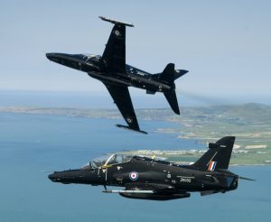
The RAF’s latest fast jet trainer, the Hawk T2 is pictured during a flight over the beautiful scenery of North Wales.
Listen
Military aircraft will often be heard before they are seen (especially in the case of helicopters) so keep an ear out for engine noise as warning that one may be close by.
What do you do if a Low Flying Aircraft is in your Area?
Military aircraft often fly at high speed and the pilot’s field of vision can be limited so it is more likely that you will see them before the pilot can see either you or your drone. The first thing to do if you suspect a low flying aircraft is close is to immediately descend your craft and then land it safely as soon as possible. Stay on the ground until the danger is clear.
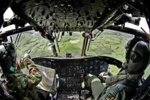
A Royal Air Force Chinook helicopter is pictured on a training flight in Snowdonia, Wales.
What else can you do to Help?
By following all the steps above, you’re not only protecting your drone investment but you are also helping to safeguard the lives of the pilots, crew and passengers that are flying, not to mention those on the ground who could be affected should a collision occur. There are two other simple things that you can do to help even further.
Wear a high visibility jacket or vest. Even if you are miles from civilisation in open space, high vis clothing will help alert a pilot to your presence. Spotting a brightly coloured person in a field will mean that the pilot can keep an eye out for a drone in the sky. It’s the same advice given to horse riders – the easier you are to spot, the more the pilot can alter their route to keep everyone safe.
Use Drone Assist. NATS offer a free drone safety app called Drone Assist (or there is a desktop version at dronesafetymap.com). It provides airspace information that you can use when planning your flights – for example flight restriction zones around airfields, as well as ground hazards where there may be safety, security or privacy concerns. As well as providing you with this information to assist you with your planning, you can (and should) add in your flight detail. It’s a simple case of tapping on your takeoff location and following the prompts to enter some basic information such as date and flight duration (it’s helpful to add your max altitude in the comments as well). Your flight is then publicly listed and anyone looking at that area will be able to see it and plan accordingly. It doesn’t replace the need for calling the RAF team but it’s great practice to get into for hobbyists and commercial pilots alike.
Working Together
Reporting drone flights will, over time, lead to a clearer map and understanding of UAV pilots requirements – in itself a valuable tool for the military in planning their essential low flight training exercises.
By working together in this way to report and record flights and receive information of potential conflicts ahead of time, drone pilots will be working alongside the military to keep the airspace safer for everyone.
Flight Safety, RAF Safety Centre
14/12/2018
Updated 21/09/2021
SAM IS ....
RAF Shawbury appeal to local drone flyers for cooperation in Low Flying Areas
RAF Shawbury posted the following on Facebook. ARPAS-UK agrees and further notes that the Low Flying Booking cell is 0800 515544 for reference.
Due to the recent flooding there has been a noticeable increase in drone activity in Shropshire and the surrounding areas. Our Shropshire neighbours are capturing images and filming the extent of the flooding from the air to record what is hopefully a once-in-a-generation event and understandably so. We have seen the results of such activity across all media channels. Drones are an amazing piece of technology that have an enormous potential for fun and we encourage their safe use but, did you know, drone operators have a legal responsibility to other aircraft and members of the public?
Shropshire and the borders of adjacent counties are part of the UK Military Low Flying Area (LFA) 9, a dedicated user area for military helicopter training. In this area there is significant low-level helicopter activity, often down to ground level and it continues despite the flooding. As a result, users of drones need to be especially vigilant if flying in this area and be prepared to land their drones at the first indication of any manned aircraft flying nearby.
Our Station Flight Safety Officer has created a leaflet on guidance to best practice when operating a drone within LFA 9, available here. This should be read in conjunction with the Drone Code available here.
Drone operators are also encouraged to notify RAF Shawbury Operations if they are planning to fly their drone in LFA 9, so that our crews can be made aware. RAF Shawbury Operations can be contacted on 01939 250 351 Extension: 7221.
Your cooperation is really appreciated and we wish you happy flying!
As the rain fell, it became crucial to the Environment Agency and the Emergency Services to map the flooding and monitor the River Steeping. The River broke its banks on Wednesday 12th June.
More than 340 tonnes of ballast were dropped by RAF helicopters to shore up a breach in the wall of the River Steeping after it burst its banks on Wednesday.
High-volume pumps were deployed by the Environment Agency to move the water away from the local area and into the catchment area for the River Haven near Boston.
However, more rain is expected on Tuesday and Wednesday and the MET Office has issued a yellow weather warning.
Lincolnshire Police have operated drones for a few years now, to support their more traditional means of policing Lincolnshire. They have been used to great effect, locating missing persons, finding those who run from RTCs, assisting with crowd dynamics, burglaries, and more. They also have thermal imaging capabilities, which are ideal for night flying too. They are also conducting Beyond Visual Line of Sight (BVLOS) training for many scenarios too.
On June 15th at 16:15, an Emergency Restriction of Flight was put in place in the area of Wainfleet and Thorpe Saint Peters from the surface to 2000ft. This applied to all manned and unmanned aircraft. The UK’s Civil Aviation Authority were able to put this into effect with only 30 minutes warning. Those needed to support the operation were given authority to fly, while all others were ordered to stay away to ensure the safety and smooth running of the operation. We will see these quick notice NOTAMs (Notice to Airmen) appear more often as drones usage increases too.
The Linolnshire Police Operators monitored the situation all through the night and all the next day. The ERF was lifted on Monday 17th June at 11am.
— Lincolnshire Police Drones (@LincsCOPter) June 17, 2019
Lincolnshire Police use the Aeryon R60 Skyranger, which – as you may have worked out – can fly in the rain and relatively high winds.
While much of this could have been done by helicopter, and they were used by the RAF to deposit the sandbags, drones offer a highly cost effective means to monitoring, meaning resources are stretched further to provide better support to the people of Lincolnshire.
Congratulations to a well run operation and thank you for all your hard work. #DronesForGood