Reflecting on 2023, we are proud to share with you the top 2023 ARPAS-UK actions to deliver on our 3 priorities:
Proportionate Regulations and Standards:
We set-up the Regulation Special Interest Group REGSIG
We responded to 6 formal consultations by the CAA or the Department for Transport
We have continued our dialogue with several teams at the CAA
We’ve set-up 7 webinars or speaker notes on regulations
Safe adoption of drones by end-user industries:
We have set-up 25 webinars this year, mostly with you members as speakers, disseminated to a broad range of stakeholders who can watch at their leisure on our YouTube channel
We organised our own ARPAS-UK annual conference hosted in Cranfield, and co-organised the drone activities for DroneX and GeoBusiness
We posted more than 200 newsfeed items on our website
We disseminated 400+ job opportunities.
Enabling the Future:
We set-up the BVLOS Special Interest Group BVLOS-SIG
We co-organised the BVLOS Risk Quantification training workshops in 4 locations across the UK
We set-up 8 webinars on future-facing issues
We are member of the Future Flight Industry Group FFIG led by the Aviation Minister and contributed to the FFIG Action Plan setting up the UK roadmap for drones and AAM, due to be released in Q1 2024
We also take part in a number of working groups and committees, representing the industry, including the NATS BVLOS forum, DfT or CAA-led forums or WGs.
We’ve additionally been involved in a Mentoring Project to encourage young people to consider a career in the drone industry.
Thank you to our members that are also active in CAA, DfT, BSI … working groups.
Through our monthly bulletins and topic-specific emails, we have done our best to keep you informed on key industry and regulatory developments. We look forward to continue our actions in 2024, with your support!
By: Anne-Lise Scaillierez. Members only: feel free to comment on this post, or share comments by email to membership@arpas.uk.
SAM IS ....
“PDRA01 Application on hold”: Top 3 reasons
We had a meeting with representatives of the CAA’s Shared Services Centre SSC team, and would like to share some useful feedback wrt PDRA01 Application on hold. In terms of process within the CAA:
The SSC team pre-screens all Operational Applications “OA” in the Specific Category
The SSC team assess the PDRA01 applications only.
The SSC team transfers the OSC applications (Case 1, Case2, and special projects) to the RPAS Oversight team.
The top 3 reasons why PDRA01 OA are put on hold by the SSC team are:
1. Inadequate Emergency Procedures. These are detailed in CAP722A 1.4.14 “Emergency Procedures”. It details the events triggering an ERP (loss of control, loss of propulsion, pilot incapacitated etc), the checklist of specific actions undertaken by the RP and the crew to reduce the impact of that particular event (activate RTH, landing etc). It also covers the checklist of actions post event (inform closest aerodromes, and/or emergency services, and/or make immediate note of chain of events, and/or report incident etc).
2. Discrepancies or lack of Flyer IDs, Operator IDs, Remote Pilot Competencies documentation for the organisation and/or the team listed in the Operation’s manual. Remember that the details must match exactly the information in DMARES.
3. Discrepancies in the legal name of the organisation applying for the OA, typically: “legal name registered on Companies House Ltd” trading as “Business Name, or Company name”.
We also noted that the text in the CAA’s response emails can appear as aggressive (“Your application is on hold”, application cancelled if no response after 14 days or if second application fails assessment), especially when the reasons for having an application on hold are not safety-driven or are not clear. The team acknowledged that the emails are standard communications issued automatically, regardless of the reasons.
Going forward, the objective is to have a distinction between:
Applications being put on hold on safety reasons
Applications that are processed and approved but with advisory recommendations and best practices that the operator must apply – for reasons that are not safety critical.
By Anne-Lise Scaillierez.
Members only: please share comments below, or by email: regulation@arpas.uk.
SAM IS ....
AAM Evidence report published by DfT
BryceTech was commissioned by the Department for Transport to assess the Advanced Air Mobility market readiness.
The UK’s Department for Transport (DfT) has published a comprehensive review on Advanced Air Mobility (AAM) titled “Advanced Air Mobility Evidence Review.” Released on December 5, 2023, and updated on December 7, 2023, this independent report, produced by BryceTech on behalf of the DfT, marks a crucial step in understanding and shaping the future of air travel.
The review meticulously addresses evidence gaps identified in DfT’s research areas, providing an in-depth overview of the current status and expected future trajectory of both the UK and global AAM industry. This includes a detailed examination of the development level and market entry timelines for various vehicles and enabling technologies, pivotal in shaping the industry’s future.
One of the key aspects of the review is its focus on the size and potential growth of the current UK and global markets for advanced air mobility. By assessing future market outlooks, the report highlights significant opportunities for industry players and policymakers. Importantly, the review identifies key market drivers and barriers, offering insights into potential government interventions that could facilitate the growth of the UK AAM market.
The AAM market is characterized by a high level of uncertainty due to its emergent nature. To address this, the review draws from a broad spectrum of literature and expertise, including contributions from a steering group comprising representatives from the DfT, Civil Aviation Authority, Future Flight Challenge, Connected Places Catapult, and various academic institutions. This comprehensive approach ensures a balanced and well-informed perspective on the subject.
The review is not just an academic exercise; it is a vital resource for stakeholders across the aviation sector, including manufacturers, service providers, policy makers, and regulators. It sets the stage for informed decision-making and strategic planning, essential for navigating the complexities and leveraging the opportunities in the rapidly evolving world of advanced air mobility.
In conclusion, the “Advanced Air Mobility Evidence Review” by the UK Department for Transport is a landmark report that offers a clear vision of the future of aviation. It is a testament to the UK’s commitment to leading in the development and deployment of innovative aviation technologies. As the industry stands on the brink of a new era, this report will undoubtedly serve as a key reference point for shaping the future of air travel, both in the UK and globally.
SAM IS ....
When Crewed meets Uncrewed Aircraft
One of the major challenges in integrating uncrewed aircraft into the same skies as crewed aircraft is that they communicate using different languages, in essence verbal vs data.
As experts in trialling advanced communications technology alongside their specialised aviation tasking, Draken Europe has been hard at work recently with their partners Volant Autonomy, supporting trials in the Agile Integrated Airspace System programme (aka ALIAS).
Last week, the ALIAS partners successfully completed their first flight trial using Draken’s crewed Diamond DA42 aircraft in proximate airspace with SkyLift’s uncrewed platform. This is the first of multiple flight trials in which Volant will be building team situation awareness, culminating in uncrewed SkyDrones, SkyLift and SkyPorts being able to operate safely and confidently in the same proximate airspace as Draken’s crewed aircraft.
Anthony (Tony) O’Connor, Draken’s Director of Strategic Bid Programmes, is leading the development of Draken’s #RPAS capability. He explained the role Draken is currently delivering in the ALIAS trials:
“We recognise there is considerable opportunity for us in building teaming capability to conduct safe UAV operations in challenging and congested airspace. Our investment in this goal is reflected in the contribution we bring to the ALIAS Project, part of Phase 3 of the Innovate UK Future Flight Challenge. The ALIAS project will deliver huge benefits in technological capability. The addition of Draken’s extensive operational experience will, we hope, result in commercial benefits for the whole consortium.”
5 December 2023
SAM IS ....
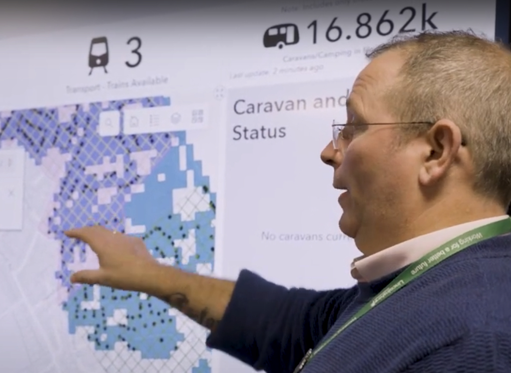
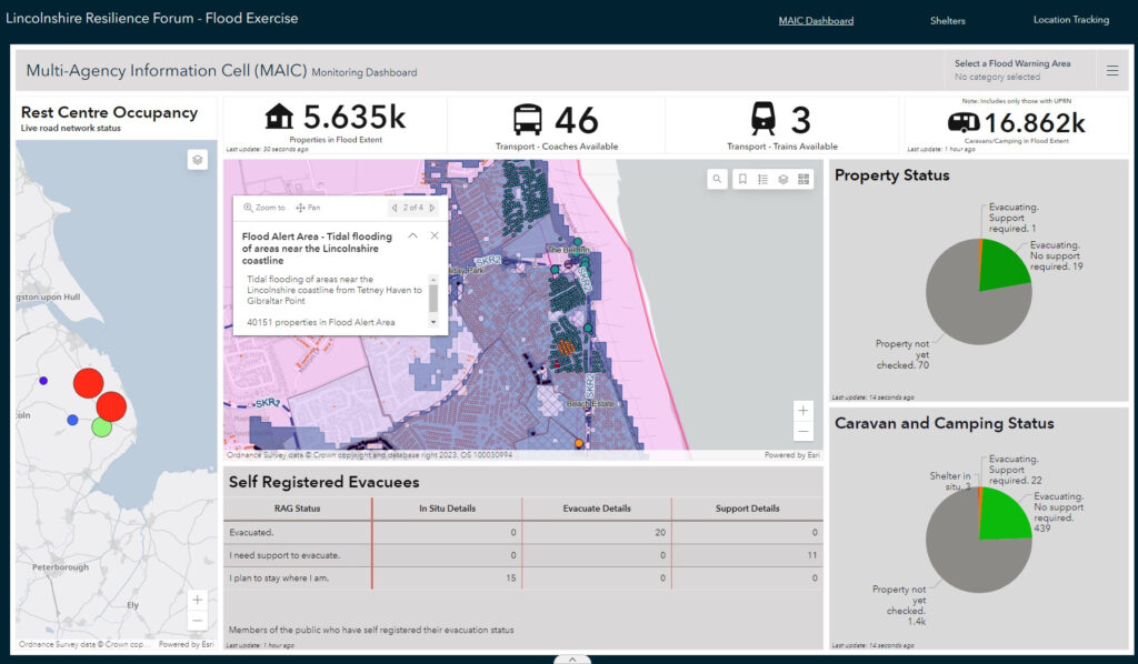
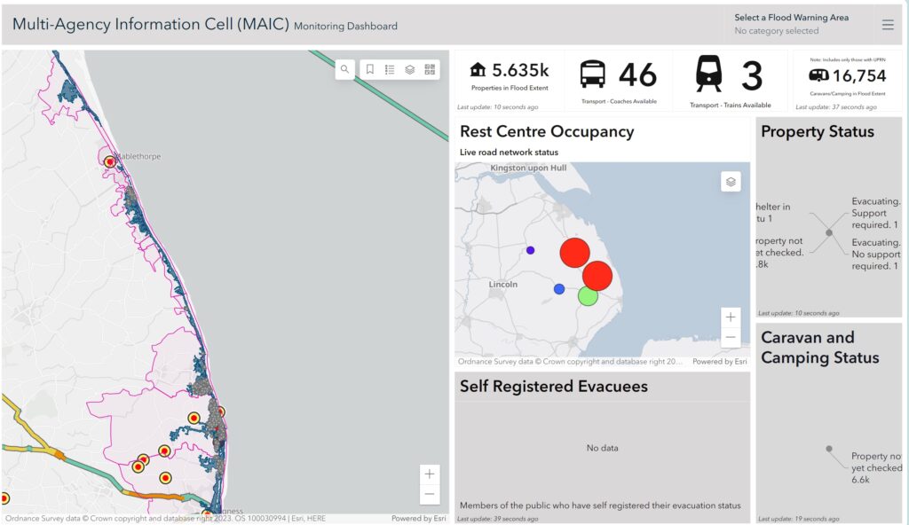
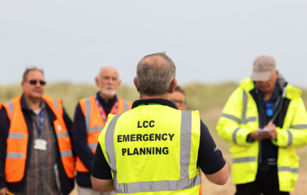
Lincolnshire Prepares for Emergencies with Drones and Digital Twins
Geospatial and drone technology from ARPAS-UK member Esri UK supports more effective response to floods, power cuts and severe weather.
Lincolnshire Resilience Forum (LRF) has gone live with new geospatial and drone technology from Esri UK to help it better prepare for emergencies across the county, including flooding, loss of critical infrastructure, pandemics or severe weather. Image recognition and drone software are among new applications helping to create real-time intelligence and an improved understanding of potential catastrophes.
Covering over 2,000 square miles and a population of more than 750,000, the LRF’s objective is to save and protect human life, relieve suffering and contain emergencies, limiting their escalation by ensuring comprehensive readiness. One of 38 Local Resilience Forums in England, the multi-agency partnership consists of over 30 category 1 and 2 responders, including local authorities, government agencies, emergency services, NHS and health bodies, utilities and transport providers.
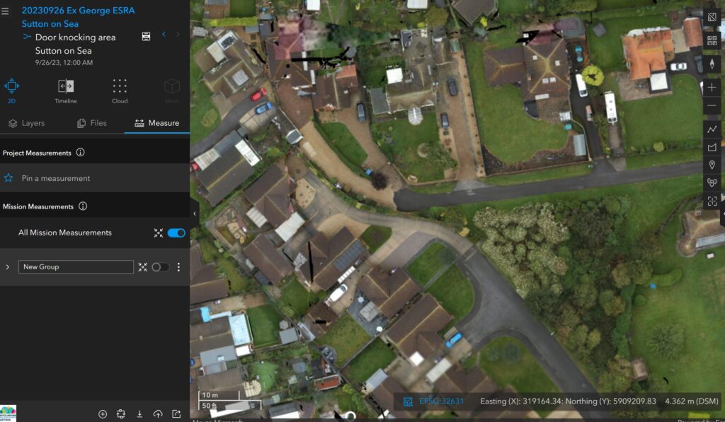
New systems are being used to identify unknown caravans using drone and satellite imagery, to gain a more accurate understanding of where residents need to be evacuated from in the event of a major flood. Preparing for tidal inundation is a top priority for the LRF due to Lincolnshire having one of the largest single landmasses in the country at risk of such an event, along with Europe’s highest density of static caravans at more than 34,000.
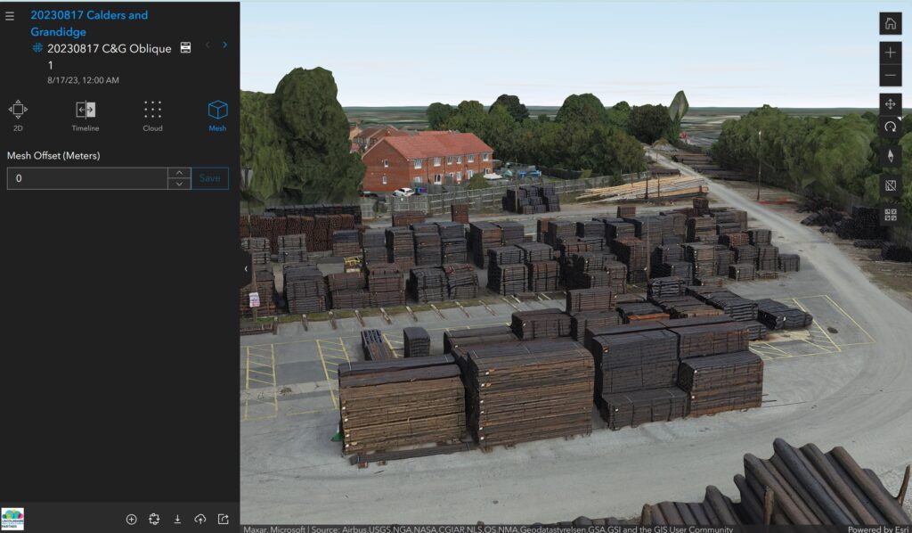
Esri drone software is making aerial data capture faster and more accurate to create 3D digital twins of potential higher risk zones, supporting better understanding of access and evacuation points in relation to homes and other properties. The new deployment means the LRF can create digital twins more quickly, particularly for Control of Major Accident Hazards (COMAH) locations, which involve dangerous substances such as gas and oil refineries.
Responding to large emergencies – particularly flooding but also major transport incidents or the loss of critical infrastructure – is a crucial role of public services. With the climate crisis comes more extreme weather events, which means community resilience is even more important.
Lincolnshire is a large county with no motorways and few dual carriageways so response and evacuation planning is critical. These new innovations are enabling emergency planners to model risks affecting the county to maximise response, improve communication and coordination and reduce, as practicably as possible, the impacts on the wider communities of the county. Creating the new caravan dataset in particular will dramatically improve intelligence.
Steve Eason-Harris, Emergency Planning Officer at Lincolnshire County Council, who is the lead officer for GIS and Resilient Communities for the LRF.
Identifying static caravans is traditionally difficult due to licensing regulations, land ownership and registry data. Now with new deep learning tools available, the LRF is exploring and developing ways of employing drone and satellite imagery and GIS to identify previously unknown caravans. Tourism is the lifeblood of many coastal regions in the country but this can increase risks to coastal populations residing in caravans when holiday seasons lengthen into storm periods. In Lincolnshire, this traditionally runs from October to March.
We’re aiming to solve a huge challenge and having the latest geospatial technology means the LRF can respond more effectively. Constant innovation is critical at the LRF, the objective being to use new systems to ensure we get the right resources to the right people at the right time
continued Eason-Harris.
At the core of the solution lies an Esri real-time mapping dashboard, providing a common operating picture, which went live in summer 2022 and was used extensively during Storm Babet in October 2023. Available online, on mobile devices and giant touch screens in the County Emergency Centre, it integrates data from over 30 agencies to allow rapid decision making. The system provides a faster and more advanced method of showing partners what the situation is before, during and after an emergency, compared to paper maps and spreadsheets.
Other new GIS projects at LRF include developing a workforce application for deploying, tracking and communicating with volunteers in the field to support vulnerable people who need assistance the most. The system will update the control centre via a mobile app when volunteer tasks have been completed and alert the team with any requests for medical intervention or transport assistance. Data from the app will also feed directly into the mapping dashboard in the control centre.
5 December 2023
SAM IS ....
December 01 2023 Drone Related Jobs
Disclaimer: All jobs posted here are from LinkedIn and other job sites including member and non-member organizations.
Unmanned Aerial Precision Spraying (UAPS) with Railscape: webinar watch again
Railscape Ltd, one of the UK’s leading commercial drone service providers, have developed, designed, and patented the UK’s first unmanned aerial precision sprayer (UAPS).
The system, designed to deliver pesticides and herbicides via a sprayer attached to a drone, means a gamechanger in managing locations considered hazardous or difficult to reach using conventional working at height methods.
UAPS delivers safety, efficiency and environmental benefits and, whilst originally designed to operate in the railway environment, the utility of the sprayer means equally challenging environments are now in scope such as restricted industrial areas or protected historical monuments.
Speaker Bio:
Ed Lewis – Operations and Project Manager for Railscape Ltd.
With over 25 years of planning and operational experience developed during a career in the British Army, Ed was ideally suited to get the UAPS project across the line and oversee the first pesticide spraying from a drone on the railway in the UK.
SAM IS ....
Maritime & Coastguard Aviation Evolution: webinar WATCH AGAIN
Join us as Philip Hanson, Aviation Technical Assurance Manager at the Maritime & Coastguard Agency discusses the evolution of Coastguard aviation and how that led the MCA to explore BVLOS drone use to support time critical missions, to increase search efficience and effectiveness, while reducing the risk to the rescuers.
Phil’s career began as an Avionic engineering apprentice at the Royal Naval Aircraft Yard Fleetlands in Gosport Hampshire.
Career Highlights include:
Implementing business change in the Defence Aviation Repair Agency
Working in MOD airworthiness policy
Management and development of UAV research programmes for the MOD
Project managing the implementation of interim Search and Rescue (SAR) Helicopter contract in introducing new technology
Project engineer for the Joint SAR Helicopter Procurement, holding airworthiness and safety delegations
Managing through life support of 20+ MOD UAV capabilities which provided surveillance and information superiority for the RAF, RN and Army.
Current role: Responsible for technical aspects and service acceptance of SAR Helicopter, Aerial Surveillance and Maritime drone capability.
SAM IS ....
ARPAS-UK & GeoBusiness in Partnership – Again!
GeoBusiness 5-6 June 2024
ARPAS-UK is delighted to be partnering with GeoBusiness on their 10th anniversary to promote the use of drones in the geospatial industry. This collaboration brings forth a dedicated Drone Conference Theatre and ARPAS-UK Members Exhibition Pavilion.
New exhibitors can benefit of an exclusive offer extended to our members: a 15% discount on booth reservations and a coveted 15-minute speaking slot on the conference theatre.
The development of the Drone Theatre continues our support for our members, as well as the wider drone industry, to improve skills, professionalism, knowledge, expertise and promote the safe adoption of drones by end-user industries.
In addition, we will be keen to ensure that the Drone Conference Theatre is packed with informative, educational presentations covering a range of topics from regulations, survey accuracy, how to be a professional drone operator, how BVLOS will affect the geospatial world and more. If you are interested in delivering a keynote, please respond to this Call for Speakers and let us know too, via membership@arpas.uk as we will co-curate speakers at the Drone Conference Theatre!
27 November 2023
SAM IS ....
Risk Quantification Courses Success
ARPAS-UK has now run two of four courses on Risk Quantification for BVLOS Operations in Stoke-on-Trent and Newport.
The feedback has been fantastic:
“The workshop opened my eyes to the processes involved in assessing factors through probability and how they are applied. It provided an ideal forum for wider discussion between industry partners around BVLOS operations and is highly recommended.”
“Big shout out to Owen McAree and ARPAS-UK for the two day event covering the challenges of beyond visual line of sight flying for drone operations. Day one went really quickly and I have already learnt so much already. Looking forward to day two!”